/images/COM-LOGO10_page-0001.jpg?width=750&height=750 "year8.jpg")
Year 10 Competition Award.
Introduction by Dr Salman Abu Sitta,11 Sept 2026
I welcome you to Year 10 of the architectural competition for the reconstruction of destroyed Palestinian villages. This year we have 21 participants formed in 13 teams supervised by 9 coordinators from 8 universities. Eleven teams submitted final plans. They are the ones competing today.
Over the last 10 years, we have a total of 358 participants from 19 universities. They produced full plans for 125 villages, some are multiples.
This competition is in fulfilment with our motto: We build… they destroy… we build again.
Yes, we built 1200 cities and villages in Palestine over the last 5000 years. In 1948, the Barbarians came to our shores from Europe in smugglers’ ships. They destroyed 530 cities and villages, depopulated them and made its people refugees, 9 million to-today.
Yes, we built. They destroyed. Not only they destroyed in 1948 but ever since, in the last 28,500 days since 1948.
Of these days, in the last 1000 days, the Barbarians have scored a unique infamous record in human history in the extent of its barbarity. In Gaza Strip, they killed and wounded over 300,000 people, mostly women and children. That is 14% of the population. In the Uk this is equivalent to ten million people.
The Barbarians destroyed every aspect of civil life: schools, universities, hospitals, homes, bakeries, water supplies and agricultural fields.
The Barbarians cut off all means of life: they starved people, prevented food, water, medicine and every kind of aid from entering Gaza.
Barbarity has now a new vocabulary in the history of mankind. It shall be a lesson for those who do not learn, and those who do not resist this scourge inflicted upon humanity.
We do resist. We built over millennia. They destroyed it over weeks. But we shall rebuild, rebuild and shall continue to rebuild.
That is why you are here today. Your colleagues in Gaza worked from tents, under the falling bombs, with or without power. We shall honour them in a special way and give them special consideration.
We welcome you here today and welcome our guests. We have members of Architects for Gaza AFG who have done valuable work for the reconstruction of Gaza. Our Jury are the initiators of AFG. We have online interested architects in our competition.
This competition could not have lasted many years, going now into the eleventh without the support of our dedicated Jury. They are professors of architecture at Westminster University and distinguished practicing architects.
Our Jury formed Architects for Gaza AFG, a group of 1000 architects world wide to rebuild Gaza.
Now I would like to reintroduce our illustrious jury. All of them are PhD doctors, professors and professional architects.
They are: Nasser Golzari Jury chair, Yara Sharif, Angela Brady and Rim Kalsoum. I would like to thank them all. (applause). Now over to Dr Nasser Golzari to start the proceedings. Over to you Nasser.
Winners and Projects
First Award : Leen AbuArayes(Team Leader), Ghazl Nour, Saeed Daghlas
Coordinator name : Dr. Mohammad Jawabreh
University : Birzeit University
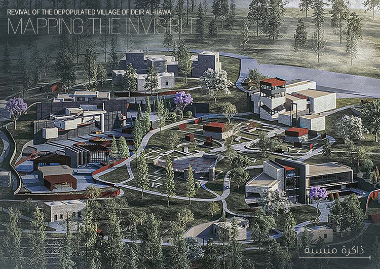
Project Title: Silent Witnesses: Revival of the Depopulated Village of Deir Al-Hawa: Mapping the invisible
An interactive archive of a layered cultural landscape shaped by time, architecture, and memory.
1. Project Introduction & Framework
1.1 Project Concept
The project transforms the core of the depopulated village of Deir Al-Hawa into a cultural heritage complex that documents and reinterprets the rural architectural heritage of the Jerusalem A‘rqoub villages across three historical phases: before the 1948 Nakba, the 1948 Nakba, and after. Through immersive spatial experiences, agricultural paths, exhibitions, handicraft production, and educational activities, heritage becomes a living cultural landscape that people experience, practice, and transmit across generations rather than preserve as static memory.
1.2 Project Rationale
Reviving a destroyed village is an act of cultural reclamation and historical preservation that reconnects people with displaced landscapes while supporting education, tourism, and sustainable heritage rehabilitation. It transforms an erased place into a space for cultural resilience and collective memory.
1.3 Why Deir Al-Hawa?

Deir Al-Hawa combines agricultural, archaeological, and historical significance. Its rain-fed terraces, layered ruins, biodiversity, hilltop setting, and panoramic views provide a strong foundation for landscape-based architecture. Its depopulation in 1948 and location between Jerusalem and Bethlehem make it a meaningful site for reconnecting landscape, identity, and history without causing further displacement.
2. Literature & Theoretical Studies
2.1 Historical Context: Palestinian Rural Life and the Nakba
Before the Nakba, Palestinian villages functioned as interconnected agricultural, social, and economic systems closely tied to the land. The Jerusalem A‘rqoub villages shared agricultural practices, cultural traditions, family relationships, and circulation routes that linked them to Jerusalem.
The events of 1948 transformed this rural landscape through occupation and displacement, disrupting established social and spatial networks. Although villages were depopulated, their physical remains and cultural practices continued to preserve collective memory, while attachment to homeland and village identity remained central to Palestinian culture.
2.2 The Jerusalem A‘rqoub Villages
The Jerusalem A‘rqoub consisted of approximately twenty-four Palestinian villages southwest of Jerusalem that shared mountainous terrain, rain-fed agriculture, cultural traditions, and social structures. Oral testimonies describe everyday life through agriculture, communal cooperation, family networks, religious practices, and memories of place.
The region's architecture was characterized by local stone construction, thick masonry walls, arches, barrel and cross vaults, and building techniques adapted to the mountainous landscape.
2.3 Traditional Palestinian Villages and Spatial Structure
Traditional Palestinian villages were compact settlements shaped by topography, agriculture, climate, defense, and social organization. Buildings and streets followed natural contours, while courtyard houses, family compounds, and hierarchical public spaces structured community life. Agricultural lands and communal facilities, including olive presses, maqamat, and guesthouses, were integrated into the settlement and often shared among neighboring villages.
Villages were classified as clustered, linear, or scattered, and according to geography as mountainous, valley, or plain/coastal settlements. Deir Al-Hawa is identified as a clustered hilltop mountain village.
2.4 Palestinian Rural Architectural Typologies
Traditional houses evolved through several typologies, including the simple house, pillar house, arch house, and vaulted peasant house. Their development reflected increasing structural complexity while maintaining close relationships between domestic, storage, livestock, and agricultural functions. Interior elements such as khawabi, mastaba, water jars, and grinding tools further illustrate this integration.
Non-residential architecture included
manateer for seasonal shelter and storage, grain mills supporting agricultural production, and
maqamat, which held religious, historical, social, and commemorative significance.
2.5 Theoretical Framework
The project approaches Deir Al-Hawa as a living cultural landscape that reconnects architecture, agriculture, memory, and cultural production instead of preserving them as isolated artifacts. This approach is based on:
- Agritourism: integrating agriculture with educational, recreational, and economic experiences.
- Heritage regeneration: reconnecting historic places with community life, tourism, adaptive reuse, and sustainable development.
- Contemporary architecture: reinterpreting heritage through innovation, sustainability, technology, and sensitivity to local culture and environment.
3. Site Analysis
3.1 Site Context and Historical Background
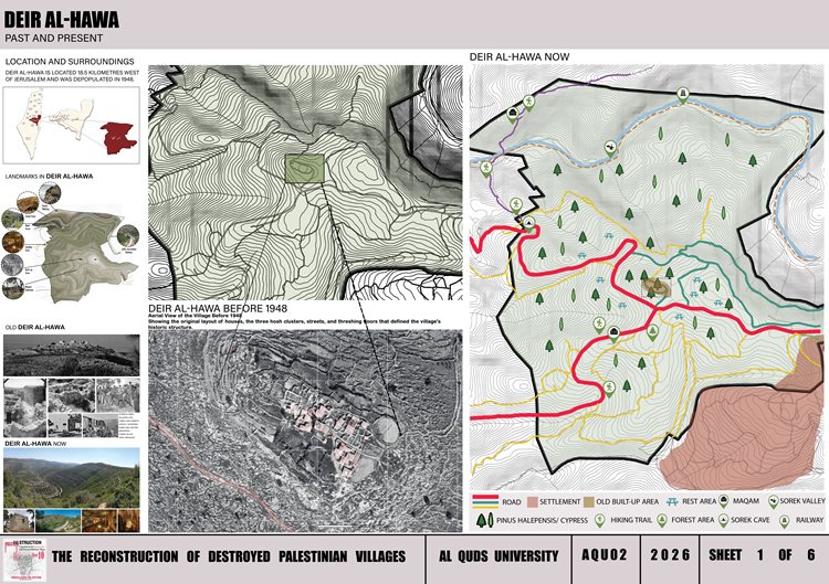
Deir Al-Hawa was a small Palestinian village located approximately 18.5 km southwest of Jerusalem at an elevation of about 650 m within the western Jerusalem highlands. Its elevated topography shaped its compact settlement pattern, agricultural terraces, circulation, and visual connections with surrounding valleys and villages. Historically, it formed part of the A‘rqoub village cluster and was connected to neighboring communities through roads and agricultural paths.
The village developed through Byzantine, Ottoman, and British Mandate periods. By the 1940s, it was an agricultural community dependent on olives, orchards, cereals, and livestock. Its clustered stone houses, narrow paths, courtyards, agricultural terraces (Salasel), and threshing floors (Al-Baydar) reflected a close relationship between architecture, landscape, and community.
3.2 Transformation After 1948
Deir Al-Hawa was captured and depopulated during Operation Ha-Har in October 1948. Most buildings were demolished, while the landscape was transformed through afforestation, new roads, settlements, and recreational areas, including the American Independence Park.
Although the village disappeared as a living settlement, traces remain through collapsed stone structures, agricultural terraces, cactus clusters, and scattered archaeological remains that continue to preserve its physical memory.
3.3 Accessibility and Environmental Conditions
Historically, Deir Al-Hawa was connected to Jerusalem, Bethlehem, and neighboring villages through regional roads and paths. Today, hiking and recreational trails continue to provide access while maintaining important visual relationships with the surrounding landscape.
The site experiences a Mediterranean climate with hot, dry summers and cool, wet winters. Its topography, solar exposure, prevailing winds, and vegetation shape its environmental character.
3.4 Site Analysis: SWOT
The site's strengths include its historical significance, strategic topography, archaeological remains, and strong relationship between architecture and landscape. Weaknesses include fragmented remains, limited spatial legibility, and reduced historical visibility. Threats include continued afforestation, parkification, and environmental deterioration. These challenges also create opportunities for an architecture of memory centered on experiential design, landscape interpretation, education, and cultural engagement.
4. Concept, Vision and Program
4.1 Project Vision & Conceptual Approach
The project revives Deir Al-Hawa through a contemporary interpretation of its spatial, social, and material identity rather than reconstructing the village literally. Its former morphology, streets, courtyards, agricultural landscape, and building patterns are reinterpreted as a new cultural experience.

A centralized spatial configuration places the original village footprint at the project's core, with supporting services organized around it. Building density gradually decreases toward the surrounding agricultural landscape, reflecting the traditional Palestinian village pattern. Stone, concrete, and corten steel bridge traditional memory with contemporary intervention.
The project follows a multi-phased strategy that progresses from land activation and agricultural engagement to knowledge transfer, participatory construction, and long-term community ownership. Streets, plazas, courtyards, and varied entrances reinterpret transitions between public, communal, and private spaces, creating a contemporary urban pulse rooted in the site's social morphology and landscape.
4.2 Guidelines for Site Intervention
Based on all of the above, the following design guidelines were developed to preserve and strengthen Deir Al-Hawa's identity:
1. Reading & Structuring the Site
Treat the site as a cultural landscape by reconnecting its historical traces, paths, terraces, and natural features. Functional zoning should follow the existing social morphology while preserving open views and the skyline.
2. Interpreting Three Historical Phases
Express the site's history through three spatial phases: Pre-Nakba rural life represented through agriculture and daily life; the Nakba through absence and rupture; and the Post-Nakba landscape through contemporary architectural intervention and future visions.
3. Designing Heritage as Active Participation
Transform heritage into a living experience through workshops, themed walking routes, and an agri-culture economy that reconnects agriculture, education, cultural practices, and community life.
4. Governance, Community & Safeguards
Support long-term stewardship through community councils, native planting, and adaptive implementation that responds to environmental conditions while protecting the site's historical character.
5. Spatial Identity
Balance the site's urban pulse, social morphology, skyline, and historical layers, introducing contemporary activity without overpowering the original landscape.
4.3 Zoning & Master Plan

The master plan is organized around a centralized core, with program zones distributed according to their relationship with the historic village, landscape, and circulation network. The layout transitions gradually from the dense historic center toward agricultural and open landscape areas while connecting all functions through pedestrian paths, plazas, and shared public spaces. It accommodates partial-day, full-day, and multi-day visits, allowing the project to function as a flexible cultural destination integrated with its landscape.
4.4 Project Program & Detailed Buildings
- Parking: The main arrival point where visitors park before walking along the original village path into the project.
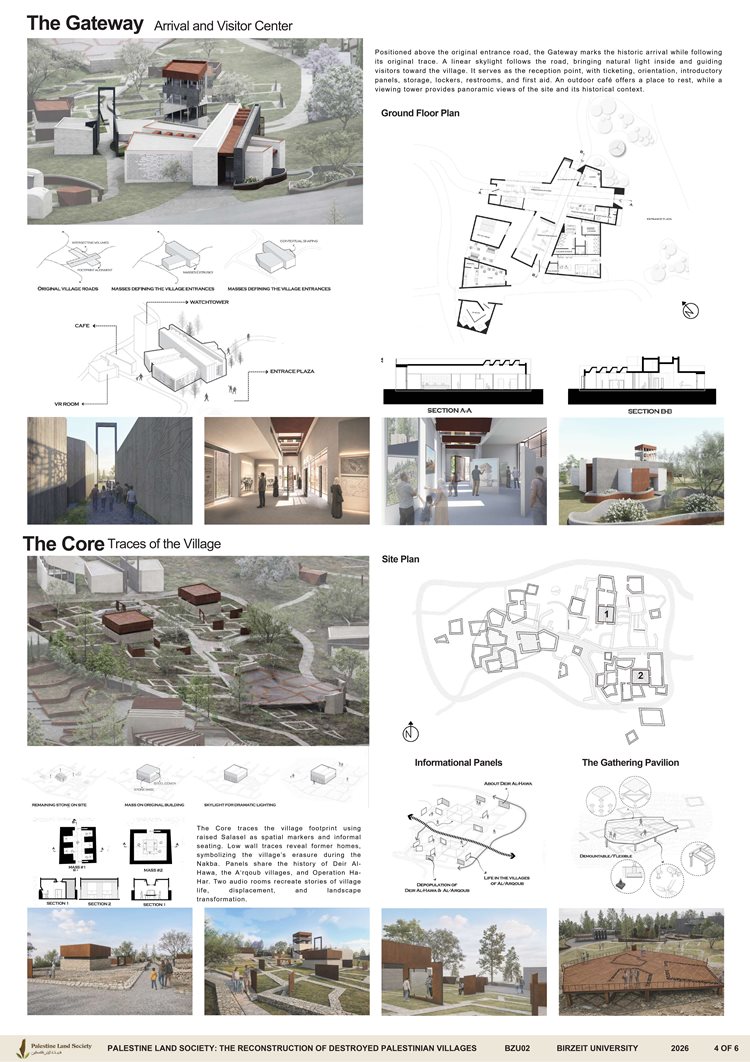
- The Gateway: Positioned above the original entrance road, the Gateway marks the historic arrival while remaining aligned with its original trace. A linear skylight follows the road below, drawing natural light into the building and guiding visitors toward the village. It serves as the reception point, containing ticketing, orientation spaces, introductory panels, storage, lockers, restrooms, and a first-aid clinic. An outdoor café pavilion provides a resting space before beginning the journey, while a viewing tower offers panoramic views of the site and its historical context.
- The Core: The Core partially traces the original village footprint using the mapped Salasel as the main spatial markers. These are raised approximately 50 cm to define space while providing informal seating. Former house walls are raised only a few centimeters—enough to reveal their footprints without obstructing movement—symbolizing the village's erasure during the Nakba. Informational panels present the history of Deir Al-Hawa, the A‘rqoub villages, and Operation Ha-Har. Two audio rooms, located within former house boundaries, immerse visitors in stories of village life before the Nakba, displacement, and the landscape's transformation.

- The Forum: Serves as the project's civic and cultural landmark, expressing the quality and scale of contemporary Palestinian architecture. Although monumental, it is partially embedded into the mountainside so only one elongated level emerges, minimizing its visual impact. This creates a sunken plaza for cultural events, markets, performances, and community gatherings, connected to a café, educational kitchen, outdoor seating, and an amphitheater. Inside, exhibition galleries, educational spaces, audiovisual archives, local craft displays, seasonal agricultural exhibitions, and interactive learning environments establish the building as a center for cultural production, knowledge exchange, and community engagement.
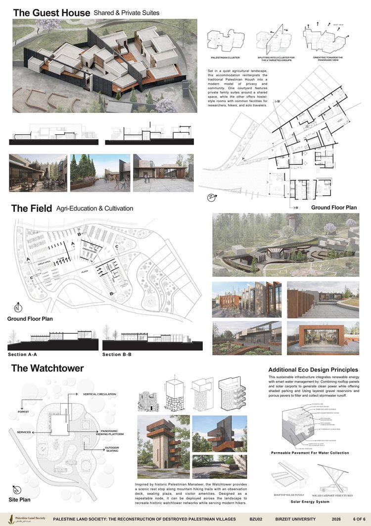
- The Guesthouse: Located in a quieter area overlooking the agricultural landscape, it offers accommodation inspired by the traditional Palestinian Housh. Two courtyards serve different users: one contains private family suites around a shared courtyard, while the other provides hostel-style accommodation for researchers, students, hikers, and individual visitors with shared facilities that encourage interaction. Together they reinterpret the traditional Housh as a contemporary model balancing privacy and community living.
- The Timeline: The Timeline guides visitors through the evolution of Palestinian rural architecture using reinterpreted building clusters that represent successive house typologies. A symbolic qanṭara gateway marks transitions between architectural forms, historical periods, and degrees of privacy. Each station recreates traditional rural activities—including olive pressing, dairy production, grain milling, weaving, embroidery, basketry, pottery, and ceramics—allowing visitors to actively experience everyday village life rather than observe static exhibitions. The building clusters align with surrounding depopulated villages, restoring visual and cultural connections across the landscape. The sequence alternates between partially constructed structures revealing traditional building techniques and fully interactive spaces illustrating architectural evolution. The experience also incorporates the village's two original Bayader: one reconstructed to demonstrate its historic function, and the other reinterpreted as a public plaza with kiosks and a small amphitheater.
- The Field: The Agricultural Center supports agricultural education and seedling production through two buildings—a teaching hall and seedling preparation space—linked by a central greenhouse. Each mass combines a concrete core with movable corten steel panels that open activities to the surrounding landscape, improving daylight, thermal performance, flexibility, and creating a unified architectural language shared throughout the project.
- The Watchtower: Located along mountain trails among existing trees, the Watchtower is inspired by the square-plan Palestinian Manateer of the Jerusalem hills. The zone includes an observation tower, seating plaza, restrooms, and visitor amenities, providing a resting point along hiking routes. Designed as a repeatable intervention, it can be placed at multiple locations across the mountain, recreating the historic distribution of agricultural watchtowers while forming a network of service nodes that integrates with the landscape.
Second Award (Joint) : Noura al Naamani
Coordinator name : Yaser Abu Nasr and Beata Dreksler
University : American University of Beirut

Project Title: Suruh, Palestine: A Future Palimpsest of Return and Repair
PROJECT STATEMENT
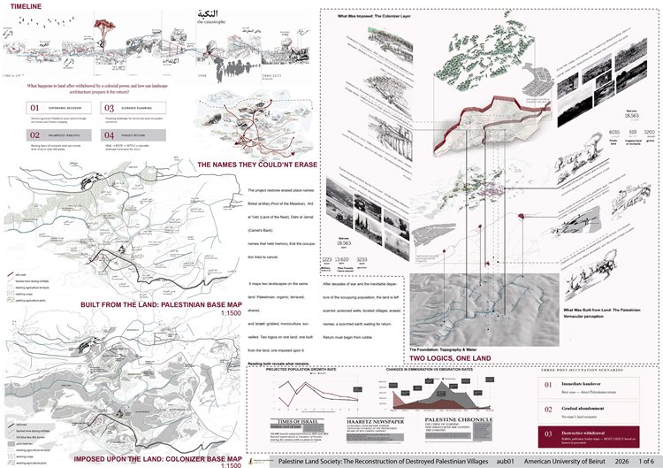
Suruh, Palestine: A Future Palimpsest of Return and Repair is a landscape framework for what happens when a destroyed Palestinian border village is returned to its people. The project asks:
After withdrawal by a colonial power, how can landscape architecture prepare the land for return?

The project integrates forensic analysis, cultural restoration, and ecological healing into one replicable methodology. It responds to place, culture, and ecology through toponymic recovery ; restoring erased names like Birkat al-Marj (Pool of the Meadow), Ard el 'Ush (Land of the Nest), and Dahr el Jamal (Camel's Ridge) ; through palimpsest mapping that overlays Palestinian and colonizer land character assessments and perceptions, through scenario planning that designs for a scorched earth withdrawal, and through a phased return: HEAL (make land safe), ROOT (plant memory), SETTLE (build community).
The design begins with a healing spine that cleans poisoned water. It evolves into a restitching spine that reconnects a system of birkehs , pools etched into the collective memory of the diaspora. It ends with The Nest, a new home rebuilt from the vernacular approach. This is not nostalgia. It is a plan. Return is not a dream. It is HEAL, ROOT, SETTLE.
PROJECT NARRATIVE
Suruh, Palestine: A Future Palimpsest of Return and Repair is a landscape-based framework for the return of destroyed Palestinian border villages. Located in the Upper Galilee near the Lebanon border, Suruh was severed from Lebanon by a colonial line in 1923 and destroyed during the Nakba in 1948. Today, JNF pine forests cover its terraces. Its cisterns are abandoned. Its names are erased.
What the Land Still Whispers: A Forensic Reading

Oral histories mapped the birkeh, paths, and invisible border. VPN access to Israeli maps and information revealed the erasure of cultural spaces. Remote sensing detected buried cisterns and terraces. 1945 RAF aerial photos showed terrace lines unchanged beneath pines. Documentaries of Lebanese villagers documented erased Arabic place names.
Tool for Reading the Land
The legibility grid, a pixel-adjusted map, guides design: sharp traces rebuild exactly, patterns reconstruct, broad zones repurpose, landforms let the land guide. Water emerged as the most legible layer across all scales — the common denominator — the place where return begins.
The Design: Matrix of Return
How the Matrix Works

● Healing Spine: The Healing Spine draws its water from the source: Ramyeh, the most immediate need for recovery. It fi lters poisoned water through phytoremediation and bioremediation across fi ve zones from border to birkeh: Border Threshold Park, Healing Hub, Agroforestry Community Garden, and Market Plaza.

● Restitching Spine: The Restitching Spine does not just reconnect roads and water systems; it reweaves the lived experience of the Palestinian village. It is a journey through memory, loss, and return. You encounter the birkehs , not as ruins, but as living places. Each birkeh has its own story, its own condition, and its own response: erased (reveal), remaining (restore), abandoned (reclaim), polluted (heal).
● Settling Spine (The Nest): Bir Ras el Sira stands as the water plaza where the new village begins. From it, the green spine extends: a living corridor of water, shade, and gathering. Along this spine lie the Educational Hub, Memorial Grove, and Healing Grove, where people gather and cultural practices take root. From the spine, green fi ngers radiate outward, expanding into hakouras that dictate where people build: a village born from landscape, not from conventional planning.
Phased Return: HEAL, ROOT, SETTLE
Return is three phases: HEAL makes land safe (1 year), ROOT plants memory (2 years), SETTLE builds community (a generation).
53 stone houses, 5 families per home, house 1,325 people , a density of 40 persons per dunum, matching the pre-1948 average.
The village economy is rebuilt through a weekly market, agroforestry production, medicinal gardens, and eco-tourism.
A restored mosque, church and synagogue stand side by side, with a cemetery on the high point, sacred spaces for a community rebuilt in diversity.
The project documents and preserves Palestinian heritage by restoring erased place names ;Birkat al-Marj, 'Ayn Suruh, Ard el 'Ush, Dahr el Jamal , and by mapping the pre-1948 landscape through oral histories, RAF aerial photos, and forensic methods. It preserves what the colonizer tried to erase.
It re-establishes the physical bond between original inhabitants and their homeland by rebuilding The Nest on its original footprint with original stones, restoring the birkehs, and reopening the paths that connect the village to Lebanon. The bond is not symbolic. It is physical.
It revives village heritage in a present-day context by reinterpreting vernacular architecture, stone houses, courtyards, hakouras, narrow alleys, with modern sustainability: green roofs, solar panels, rainwater harvesting. This is not a museum. It is a living village.
It affi rms the Right of Return through a plan that is operational, phased, and replicable. HEAL makes land safe. ROOT plants memory. SETTLE builds community. Return is not a dream. It is a plan.
Conclusion This project is not a museum. It is not nostalgia. It is a plan: operational, phased, replicable. A village born from landscape. Return is not a dream. It is HEAL, ROOT, SETTLE. The land remembers. The water fl ows freely. The people return home.

Third Award : Shaden Jawad Aqraa
Coordinator name : Dr. Hasan Al-Qadi
University : An Najah National University
Project Title: Ed Dawayima - Hebron
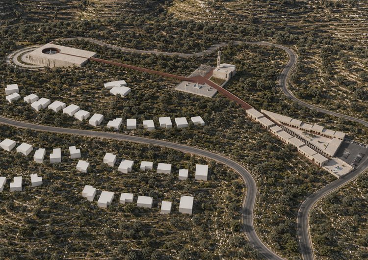
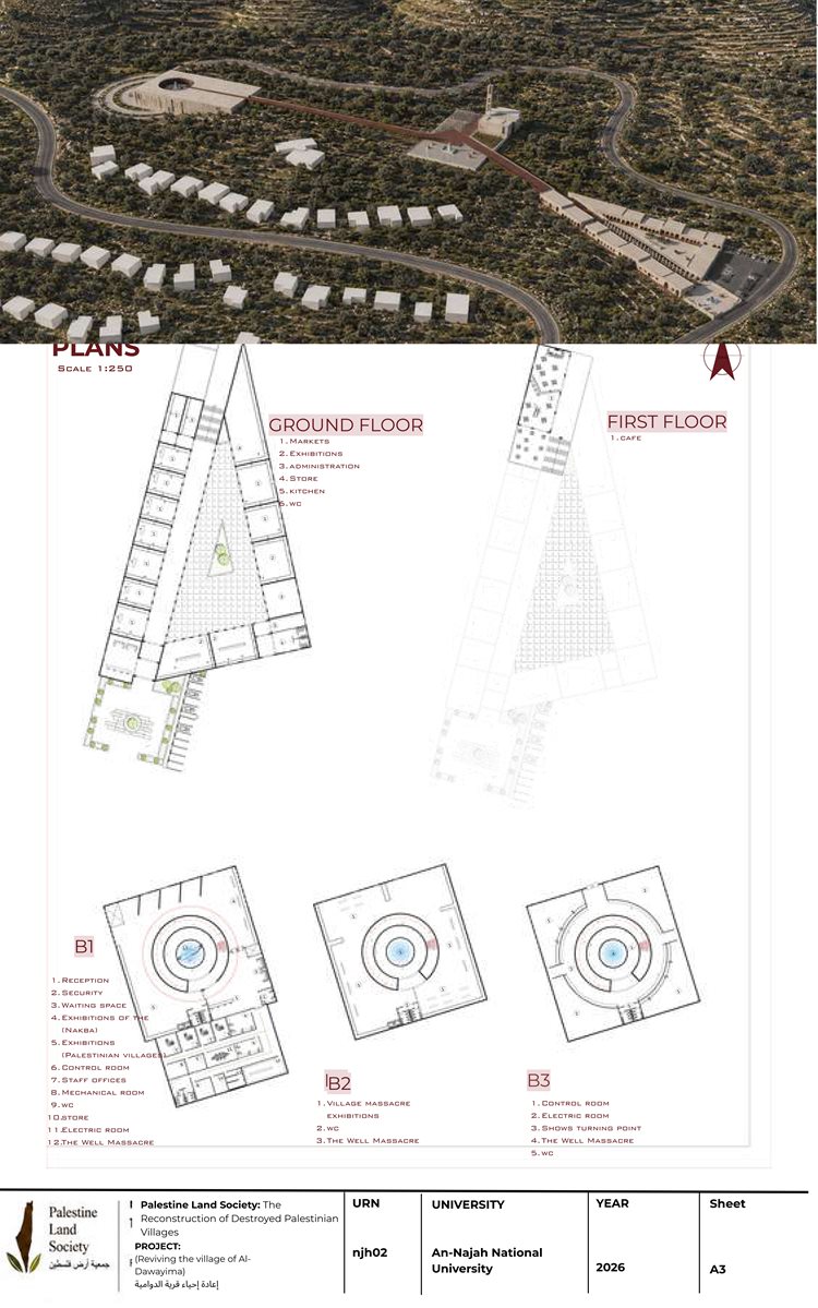
THE UNSEEN Project Brief The Unseen is an architectural memorial and regeneration project that seeks to bring the forgotten story of Al-Dawayima Village back into the collective consciousness. The project responds to a place whose history, people, and memories have gradually become unseen, transforming the landscape into a living narrative that allows the past to be experienced rather than simply documented.
The project is structured as a continuous journey through three interconnected stages: life before the Nakba, the moment of rupture, and life after the Nakba.
The journey begins at Souq Al-Bareen, representing the life of Al-Dawayima before 1948. The market recalls the social and economic life of the village, including its traditions of grape production and embroidery. Rather than reconstructing the village as a replica, the project reactivates its spatial traces and uses Palestinian stone and arches inspired by the original village architecture to reconnect contemporary intervention with the identity of the place.
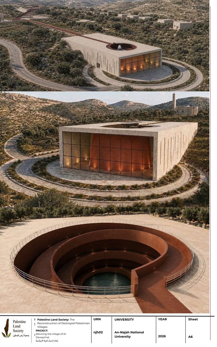
From the market, a continuous red path guides the visitor toward Al-Zawiya Mosque, located at the highest point of the village. Here, the experience shifts from everyday life to the moment of rupture, where people were killed while gathered for prayer. The mosque is reinterpreted as a memorial landscape, incorporating water pools dedicated to the victims and 75 memorial panels representing the 75 victims. A viewpoint within this area overlooks the village, allowing the visitor to confront the relationship between memory, landscape, and place.
The red path then continues toward the historic well, where one of the most painful memories of the village is embedded: people were buried alive inside the well. Once a source of water and life, the well becomes a symbol of loss and buried memory. It is transformed into the entrance to an underground museum, where a spiral ramp gradually descends beneath the ground. The descent represents entering the layers of history that have been buried and left unseen.
After passing through the museum, the visitor returns toward the surface and enters the olive and grape fields, representing life after the Nakba. This final stage transforms the narrative from loss into continuity. The fields symbolize resilience, rootedness, and the persistence of life through generations. Through movement, material, landscape, and memory, The Unseen transforms the site from a forgotten landscape into a place of remembrance and living continuity. The project does not attempt to reconstruct the past as it once was; instead, it makes the unseen visible, allowing memory to remain present within the land and allowing the story of Al-Dawayima to continue through architecture.
The project does not seek to reconstruct the past, but to make its memory visible and its life capable of continuing.




Commendation : Misk Basim Khwailed
Coordinator name : Dr. Hasan Al-Qadi
University : An Najah National University
Project Title: Reconstruction of the Destroyed Palestinian Villages
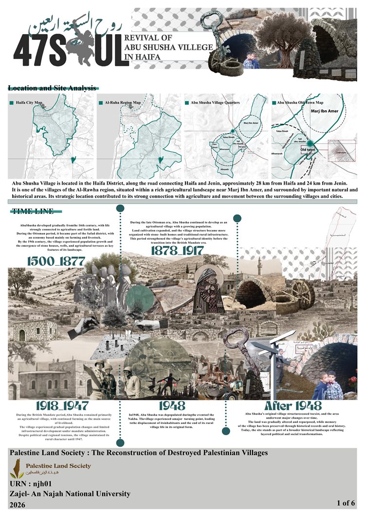

Abu Shusha Village - Haifa (47 SOUL – روح السَبعة و أربعين)
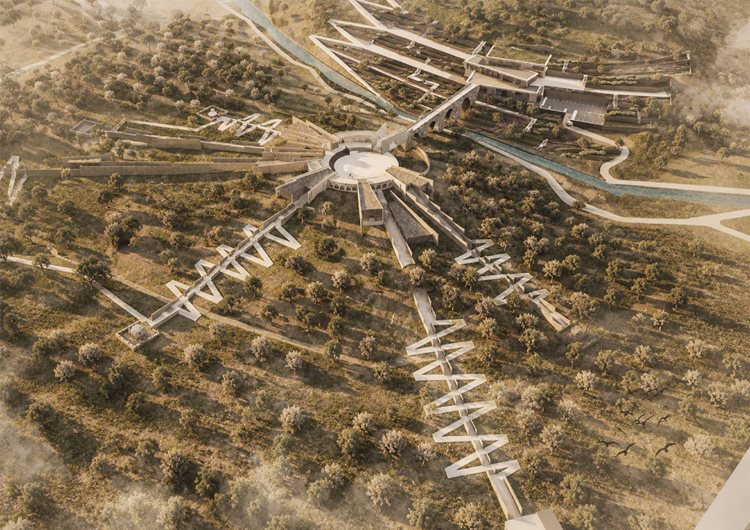
47Soul is based on the idea of reviving Abu Shusha Village by rebuilding the relationship between people, memory, heritage, land, and the future. The project does not treat the village as an archaeological site separated from its present, nor does it limit revival to rebuilding the lost buildings. Instead, it aims to restore the spirit of the place and the relationships that once connected people to the village and its land.
From this idea, the recovery of memory is transformed into a spatial experience that visitors can experience through movement. The journey begins with the memories and remains of the village and gradually extends toward the land and agriculture as a vision for its future.


The project is based on continuous movement as a main design principle. The path acts as the backbone of the project, connecting all its parts and creating a continuous experience instead of treating each building or site as a separate element. The journey begins at the Khan, continues through the introductory exhibition and museum, then extends toward the archaeological sites across the site before reaching the agricultural hill. In this way, movement becomes a tool for discovering the village and reading its history.
Another main principle is preserving what remains and connecting it to the project. Instead of moving the archaeological remains or separating them from the new use, they are kept in their original locations and integrated into the visitor's journey. Each archaeological site becomes a point of discovery connected to the exhibition that explains its history. The visitor moves from understanding the history inside the museum to experiencing the actual remains in their original setting. This approach protects the authenticity of the place while giving the archaeological elements an active role within the project.
The design also focuses on connecting history with place. The history of Abu Shusha is not presented only through information, but through the actual places where this history took place. The relationship between the museum and the archaeological sites is therefore organized to create a clear journey between knowledge and experience, from learning about the history, to reaching the site, and finally discovering it within its real context.
Respecting the site and its topography is another important principle. The hill, land, and natural agricultural terraces are treated as part of the identity of the project. The movement follows the natural character of the land, while the architecture adapts to the existing topography instead of making major changes to it. This approach continues toward the agricultural hill, where the design follows the natural terraces and reconnects architecture with the landscape.
Integrating the History and Heritage of Abu Shusha
The history and heritage of Abu Shusha are integrated into the project by treating the remaining archaeological elements as active parts of the design, rather than as separate objects. This begins with the Khan of Abu Shusha, which is rehabilitated as the reception point and the beginning of the journey, bringing back its role as a place connected to the movement of people within the village.
The main path then connects a series of archaeological sites that represent different aspects of the village's history, including the Sheikh Abu Shusha Shrine, the village well, the mosaic floor site, and the olive press. Each site is reached through a path connected to the exhibition that introduces its history. This creates a direct relationship between the story presented inside the museum and the actual place where that history happened.
Instead of being treated only as preserved remains, these elements become living stops within the architectural journey. Their locations also help shape the movement and organization of the project.
Through this approach, the project does not attempt to reproduce the past exactly. Instead, it preserves what remains and gives it a new role within contemporary life. The archaeological remains stay in their original context while becoming part of an experience that allows visitors to understand their historical and cultural value.
Agriculture as Part of the Village Identity
The revival of Abu Shusha cannot be separated from agriculture, which was an essential part of the life of the village and an important source of work and connection to the land. Therefore, agriculture is not treated as a decorative landscape element, but as an important part of the project's program and identity.
The architectural journey reaches the agricultural hill at the end of the main path, where a productive agricultural center is introduced. The center follows the natural agricultural terraces of the land and works with the existing landscape.
Here, agriculture moves from being a memory of the village's past to becoming an active and productive activity that can contribute to its future. This reflects one of the main ideas of the project: reviving the village does not only mean recovering what was lost, but also reactivating the elements that shaped its life, especially the land and agriculture.
Therefore, the journey of 47Soul moves from memory to heritage, from heritage to land, and from land to the future. Architecture becomes a tool for reconnecting people with the place, preserving the history of the village, and bringing back its agricultural identity as part of a new vision for its future.
The goal of 47Soul is not simply to create a museum that documents Abu Shusha Village. Instead, the project aims to revive the village as an integrated spatial, cultural, and agricultural environment. It transforms memory from something static that is displayed inside a museum into a living experience connected to the actual place. At the same time, it rebuilds the relationship between people and the land that was once an essential part of village life.
The project therefore moves gradually from the past toward the future. The journey begins by recovering the memory of the village and understanding its history, then continues through the remaining archaeological sites, and finally reaches the agricultural hill and its productive center.
This transition represents a vision for the future of the village after liberation. Revival is not understood as simply rebuilding what once existed, but as an opportunity to create a new life based on land, agriculture, heritage, and identity.

The main design fundamentals are based on the continuous path, connection between the museum and archaeological sites, respect for the site's topography, preservation of existing heritage, and the relationship with the land.
The path acts as the main connecting element between all these components. The museum works as a tool for understanding and reading the history of the village, while the archaeological sites provide physical evidence of its past. The agricultural hill then becomes a place for productive activity and a symbol of the future.
In this way, the project is transformed from a collection of buildings and spaces into one continuous journey that begins with memory and ends with action, from knowing the village, to discovering its remains, and finally restoring its relationship with the land.
This journey represents the essence of 47Soul: architecture becomes a way to reconnect what was separated, people, place, memory, heritage, and land, and to transform the memory of Abu Shusha from a preserved past into a future that can be revived.
Commendation: Amneh Awesat
Coordinator name : Dr. Maha Samman
University : Al Quds University- Palestine
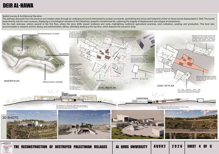
Project Title: Reviving the Depopulated Village of Deir al-Hawa: From Agrarian Memoryscapes to Productive Sustainable Development.
1. Introduction & Conceptual Framework: Architecture as an Act of Return and Memory
The project for reviving the depopulated village of Deir al-Hawa in Jerusalem's Al-Arqoub region stems from an architectural and philosophical vision that goes far beyond traditional restoration or stone reconstruction. It is a deliberate endeavor to reclaim the site as a living entity imbued with collective memory. The Palestinian rural village was never merely a transient settlement; rather, it embodied sustainable living, a profound bond between people and land, and harmony with agricultural cycles.
Consequently, the project treats Deir al-Hawa as a living memory—not as a static museum meant for passive contemplation, but as a productive ecosystem and sustainable community. Grounded in pre-1948 heritage, the project redefi nes the relationship between humanity and the earth, posing a fundamental question: How can architecture become an act of return, and how can spatial memory transform into an engine for cultural and economic revival?
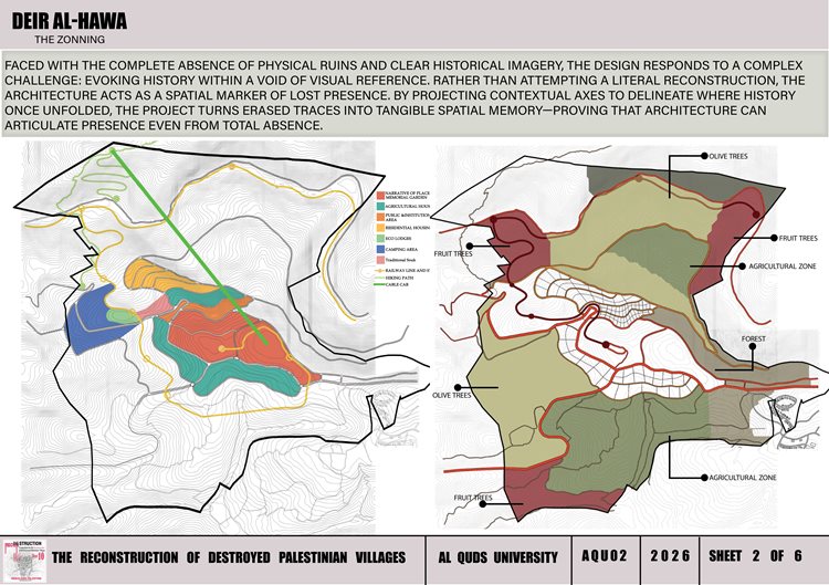
2. Comprehensive Urban Planning Across the 5,907-Dunum Scope
The intervention spans an entire geographic and historical area of 5,907 dunums, requiring a broad and meticulously studied planning approach. Urban rehabilitation extends far beyond the historical core through an integrated network comprising:
Walking Trails and Historic Pathways: Reviving old circulation routes between fi elds and agricultural terraces to off er visitors and residents a contemplative, slow-paced movement experience akin to that of the traditional Palestinian farmer.
Reclaimed Agricultural Terraces: Restoring and cultivating the terraced stone fi elds that form the spine of the site’s topography, bringing them back into active agricultural production.
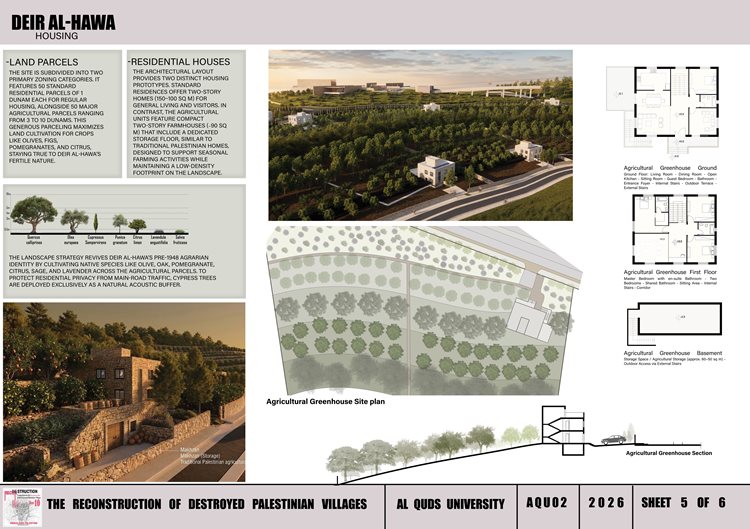
Distributed Housing Sectors (Standard and Agricultural Housing): The master plan introduces two primary typologies:
Standard Residences distributed across 50 plots (1 dunum each), featuring two-story homes (100–150 sq m) for general living and visitors; and
Agricultural Units distributed across 50 plots (3–10 dunums) to support seasonal farming. These farmhouses feature a traditional Palestinian ground-fl oor storage unit (
Makhzan) and an upper residential level (~90 sq m).
Communal Facilities: Designed to serve both local inhabitants and visitors, ensuring enduring social and economic vitality.
3. The Built-up Area: Architecture of Narrative and Memory
The primary architectural intervention focuses on the original 4-dunum Built-up Area, where the
Story-telling Spatial Complex emerges as the narrative and visual threshold of the project.
Concrete Walls Bearing Memory: Concrete walls of varying, carefully engineered heights trace the site's contours, rising precisely upon the foundations of the demolished houses. These walls serve as spatial canvases carrying artworks, inscriptions, and visual narratives that recount the history of Deir al-Hawa and its people.
Functional Components of the Complex: The complex brings together the following core facilities:
1.Exhibition Center: A cultural space showcasing the village's history, tangible and intangible heritage, and oral histories.
2. Village Restaurant: A space off ering traditional cuisine deeply rooted in local land and seasonal crops.
3. Agricultural Production & Craft Facility: Housing an olive press, mills, and dedicated workshops for local traditional crafts, bridging past and present through a real productive economy.
4. Landscape Design and Graduated Agrarian Belts
The central complex is framed by a carefully structured network of graduated agricultural belts refl ecting Palestine’s diverse biodiversity:
Botanical Graduation: Moving from the immediate surroundings outward, the landscape transitions from aromatic and medicinal herbs, to cacti and desert plants, to fruit trees (pomegranate, fi g, lemon), and fi nally to expansive olive groves covering the hills.
Interactive Experience: These open fi elds allow visitors to engage in hand-harvesting seasonal crops, reinforcing a sensory and physical connection to the earth.
Natural Acoustic Buff ers: Cypress trees (Cypress) are strategically planted along main access roads and sensitive edges to act as natural wind and sound barriers, securing visual privacy without compromising the authentic ecological fabric.
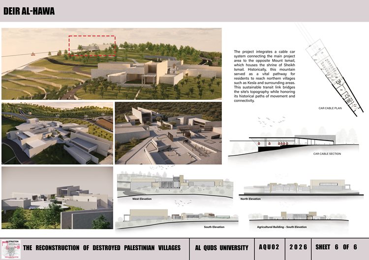
5. Deir al-Hawa Summit and Teleferic: Bridging Land and Sky
The project culminates at the village’s highest summit (675m above sea level), crowned by a sprawling 150-dunum park off ering lush green spaces and unique viewing platforms.
The Cable Car (Teleferic) Link: A modern, sustainable transit system bridging the main project zone across the topography to the opposite Mount Ismail—home to the historic Shrine of Sheikh Ismail.
Historical and Functional Context of the Mountain: Mount Ismail was historically a vital pathway used by residents to reach northern villages such as
Kesla and its surroundings. The cable car revives this spatial and functional connectivity within a contemporary, low-impact sustainable framework.
6. Reactivation of the Historic Jaff a-Jerusalem Railway: The Journey as Recovery
Extending beyond the summit and village, the project taps into regional historical infrastructure by
reactivating the historic Jaff a-Jerusalem railway.
Restored carriages ascend from the valley fl oor toward the summit through successive historical stations such as
Soreq Cave and the
Maqam of Sheikh Sulayman.
The train journey transforms from mechanical transport into a
living narrative and visual experience, allowing travelers to merge with the unfolding landscape and layers of history, turning the act of arrival itself into a journey of reclaiming memory, land, and place.
7. Why This Project Deserves Recognition and Winning Selection
The project validates its excellence through fi ve core pillars, establishing a replicable model for depopulated Palestinian villages:
1.A Layered Vision: Operating simultaneously at three scales—urban re-planning across 5,907 dunums, architectural intervention in the 4-dunum core, and landscape design within the 150-dunum park.
2.Architecture as Narrative: Transforming concrete and stone walls into spatial acts of remembrance against erasure, translating absence into a tangible physical presence.
3.Productive Sustainability: Preventing the village from becoming a static museum by reviving its agrarian identity through an olive press, craft workshops, and seasonal belts.
4.Journey as Experience: Reactivating the historic railway and cable car to make arrival a holistic experiential sequence echoing the farmer’s pace.
5.Contextual Authenticity:Rooting all architectural forms and materials in the vernacular language and topography of the old village rather than imposing foreign interventions.
8. Conclusion: Architecture as an Act of Resilience and Return
Ultimately, the Deir al-Hawa revival project demonstrates that Palestinian architecture can transcend concrete and stone to become a primary defense of identity and memory. It proclaims that land cultivated and cared for with love and rigor is never abandoned by its people. Today, Deir al-Hawa is no closed chapter of the past, but a living blueprint for the future—a profound affi rmation that rooted identities will eventually blossom into return.
-Raghad-Adawi.jpg?width=750&height=529)