The Survey of Western Palestine Revisited:
The Visible and The Hidden
Two lectures: The first lecture was given at Palestine Exploration Fund (PEF), on 26 Feb 2020, organized by Felicity Cobbing and introduced by PEF Chairman, Dr. Casey Strine (Sheffield University). The second lecture was given at SOAS, University of London, on 28 February 2020, organized by Maggie McNulty of Council of British Research in the Levant (CBRL) and introduced by Prof Michael Talbot (University of Greenwich).
Salman Abu Sitta
Founder and President, Palestine Land Society, UK
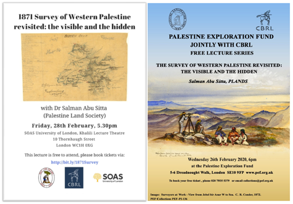
Fig-1. Lectures invitations
You can jump to any segment:
03:00 INTRODUCTION
06:55 SURVEY AREA
09:20 ACCURACY
14:10 NEW FOUND MATERIAL- TRACES AND COMPOSITES
16:18 NEW PEF ATLAS
22:22 TABLES, Generated Statistics
23:07 COMPLIANCE WITH THE SURVEY MISSION
27:35 CRUSADES’ SPIRIT
30:00 THE PEOPLE OF PALESTINE
31:45 NU’MAN QASATLY 35:25 ERASING HISTORY
37:02 Who Benefitted from the PEF Survey? Was it preserving the heritage of Palestine?
46:32 COLONIZATION
50:07 SO WHAT DOES THE NEW ATLAS OFFER?
50:57 CONCLUSION
------------
Thank you note to organizers and introducers.
- INTRODUCTION
Palestine, the Holy Land, has been the subject of interest of the old world for at least the last two thousand years. Its inhabitants, the Palestinians, adopted Christianity, then largely converted to Islam in the seventh century. They remained living in about 2000 localities in Palestine. During Palestine’s long history, armies came, conquered and left, but the population remained in situ for centuries. That was the case until Al-Nakba of 1948, when the population of Palestine was largely depopulated and their localities destroyed.
Up until the 19th century, there were very few cartographers charting Palestine. A notable exception is the Muslim geographer, Muhammad Al Idrisi (1100-1165) who created the World Map which included Palestine.
In the last two hundred years, there was a flurry of activity by travelers, priests, officers, surveyors, spies, and artists. (Figure 2, a,b,c) The opening salvo was delivered by Napoleon Bonaparte in his expedition to Egypt and Palestine (1798- 1801). His 150 savants produced the voluminous La Description de l’Egypte, documenting many aspects of Egyptian life. His surveyor Colonel Pierre Jacotin, (1764-1829) produced the first scientifically charted map of Palestine’s coast.
Fig-2a. Fig-2b. Fig-2c.
This French survey of Egypt was the envy of Europe. Many tried to imitate it. The Germans were not far behind. By the mid19th century, maps of Palestine by Kiepert and Van de Velde became very well known.
Opening the Suez Canal in 1869 as a French project increased the British desire for competition. When PEF was formed in 1865, they sent a survey mission to Sinai near the Suez Canal, ostensibly to study the Exodus Route (1869). Another mission was sent to Jerusalem (1867-1870).
The Survey of Western Palestine was carried out in Palestine from 1871 until 1877. It was named ‘Western’ on the assumption that Palestine extended east of River Jordan. They produced 26 maps and 10 volumes of text.
- SURVEY AREA
PEF Survey Area (Figure 3).
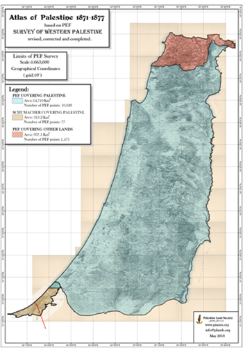
Fig-3. Limits of PEF Survey
The area covered by PEF survey extended from Litani river, today in Lebanon, in the north, to Wadi Ghuzzeh in southern Palestine. The survey covered an area of 15,648 km2, of which 14, 710 km2 were in Mandate Palestine. It covered only 56% of Palestine. We added Schumacher map of 1886 which covered a coastal strip to a distance of 42 km.
I am sure many of you know about the history of PEF survey. I do not need to repeat it here. I will concentrate on the survey’s main product, the maps.
From 1989, almost 30 years ago, when I first got hold of the maps and memoirs, I was fascinated by the detailed record of my country, Palestine.
Here it was; a living history museum, beautiful landscape, varied terrain from sea to mountain to river, thousands of names of localities, places, and features. Every stone speaks. Every flower, every bird had a different color. Every place is a witness to history.
Then the happy story came to an end. Since 1917, Palestine endured a century of destruction, for its people, for its history and geography.
Is it worth recovering its erased record? Should we salvage the destroyed heritage?
Of course, the answer is yes.
- ACCURACY
The first thing to do is to ascertain the accuracy of the PEF 26 maps..
The maps were hailed at the time as “extraordinarily accurate” and “its accuracy has been attested by official experts”. Nevertheless, it has been known quite early that the accuracy of the maps needs another look.
Over a decade ago we reported to PEF that we found considerable errors in the location of points up to 450 meters in the east direction and up to +,- 60 meters in the north direction. Even with this lack of accuracy, we must appreciate the difficult conditions of the survey in the late 19th century, traveling on horses, setting up 192 camps by diverse survey teams. Under these conditions, the resulting accuracy should be highly commendable.
Now with modern technology, we shall try to find the source of the inaccuracy and find ways to reduce it.
From our examination of PEF records here In London, we found that the field maps- known here as traces- were fairly accurate; they match modern maps in their local area of interest. After the fieldwork was completed, the work was taken to England to make the Great Map. Here the location of the points needed to be defined as an acceptable projection.
We tried three methods to improve the accuracy of the map which are described in the online version of this lecture. Finally, we selected the third.
Method 3: (Figure 4): Method 3: Rectification with Triangulation Points
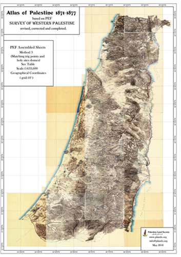
Fig-4. Assembled Sheets
To rectify as many points as possible matching triangulation points and domes of holy sites with the same points in the accurate Atlas of Palestine.
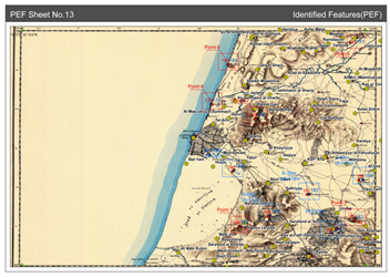
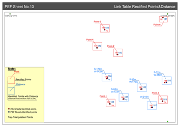
Results are shown here for a typical PEF sheet no 13. (Figure 5 - a, b, c, d)
 -->
--> 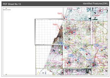
Fig-5a. Identified Features (PEF) Fig-5b. Identified Features (20k)
 -->
--> 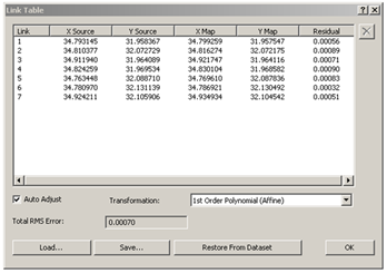
Fig-5c. Rectified Points & Distance Fig-5d. Link Table
This method reduced the errors for each sheet but did not eliminate them. In effect, this means that errors in each sheet have been reduced and distributed evenly within each sheet.
We checked 313 points. The average residual of all points in the east direction is 2.3m and in the north direction is 0.5m.
This is the method we adopted for the new PEF Atlas.
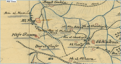
- NEW FOUND MATERIAL- TRACES AND COMPOSITES
During our research, we found new material done in the field but not fully utilized in the final production. Through a contract with PEF we acquired and examined 188 traces (field maps) and 87 field reports. This is in addition to 12 traces by Kitchener we found them in the British Library.
Here are two examples of the traces:
This one is for Qadas in northern Galilee (Figure 6). You can see the beautiful detail. Names of places are listed separately to the right.
Another one is for the historical city of Acre or Akka. (Figure 7)
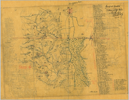
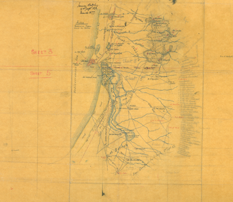
Fig-6. Qadas Trace Fig-7. Akka Trace
Here are the assembled traces covering the whole area. (Figure 8)
Furthermore, we found 11 maps which we call Composite maps. (Figure 9) These seem to be generated in the UK as an intermediate map before the Great Map was prepared.
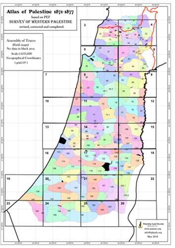
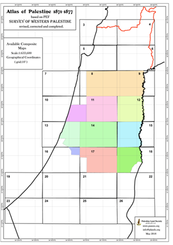
Fig-8. Assembley of Traces Fig-9. Available Composite Maps
- NEW PEF ATLAS
Now let us recall the published PEF map. This one shows the areas covered each year by the survey team in the 19th century. (Figure 10a)
Fast forward 150 years we come to our new PEF Atlas of Palestine presented today. (Figure 10b)
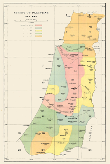
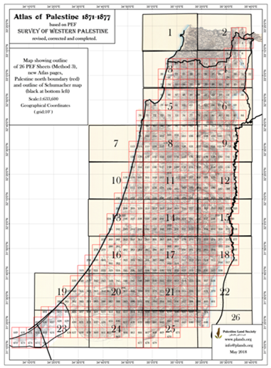
Fig-10a. 19th Century PEF Map Fig-10b. New PEF Atlas of Palestine
The new atlas appears in 497 pages, size of the page (24x 34 cm gross- 22x31cm net) to a scale of 1:25,000, showing the sum of all information newly found.
Its Geographical projection is the established Palestine 1923. These details are found in the GIS system. (Figure 11- a, b).
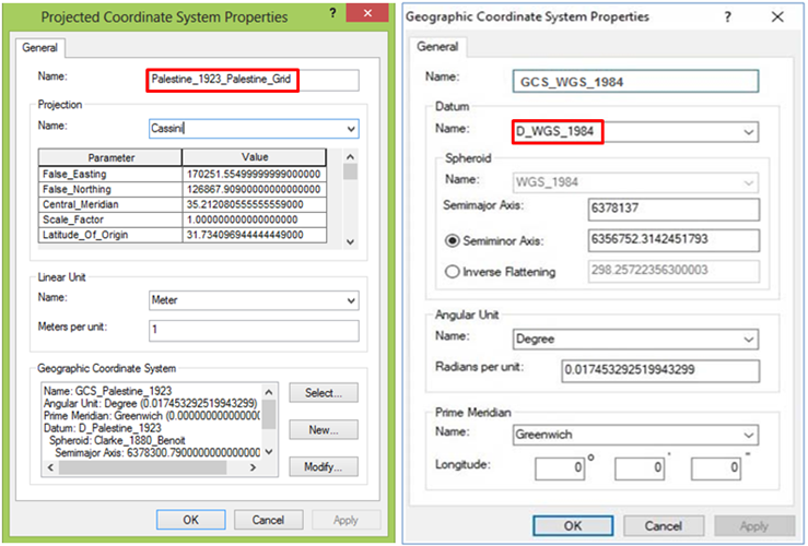
Fig-11a. Projected Coordinate System Fig-11b. Geographic Coordinate System
What did we add?:
(Figure 12 - a, b). We added 4000 new names. We added many new details not found the Great map. We added symbols of feature points, especially historical. We wrote in full the abbreviated names. We added corrected Arabic and English names. We added contour shading DTM= Digital Terrain Model. We added the Schumacher map of 1886.
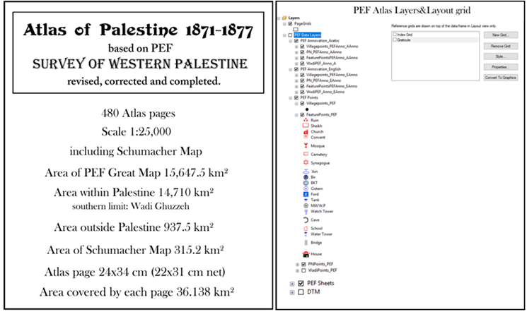
Fig-12a. Fig-12b.
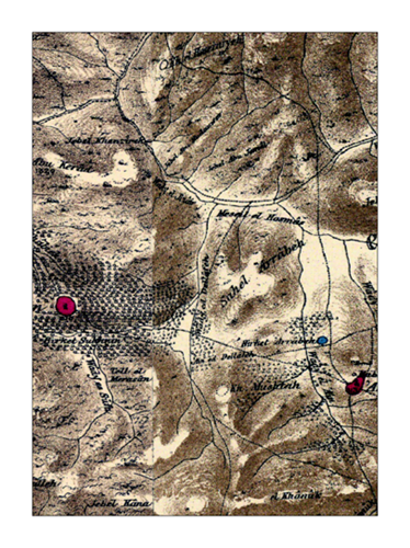
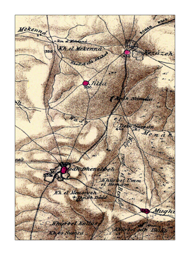
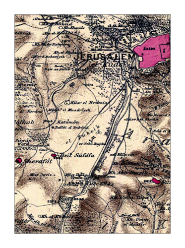
So now here is a typical page of the original PEF sheet. (Figure 13a).
Here is the new Atlas page (Figure 13b).
 -->
-->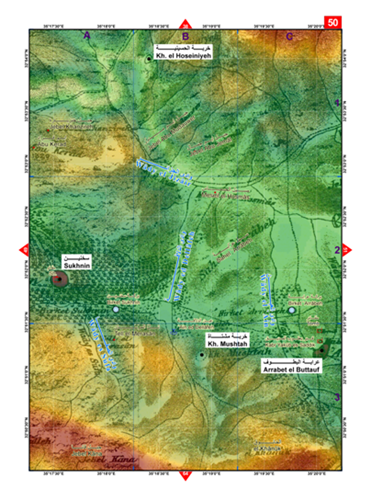
Fig-13a. Fig-13b.
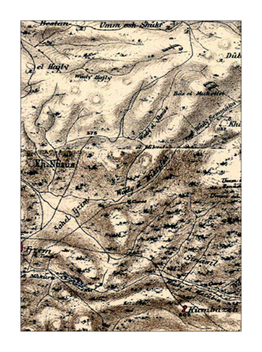
Here there are additional examples of Atlas pages. (Figures 14ab to 18ab).
 -->
-->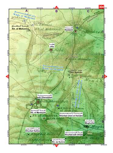
Fig-14a. Fig-14b.
 -->
-->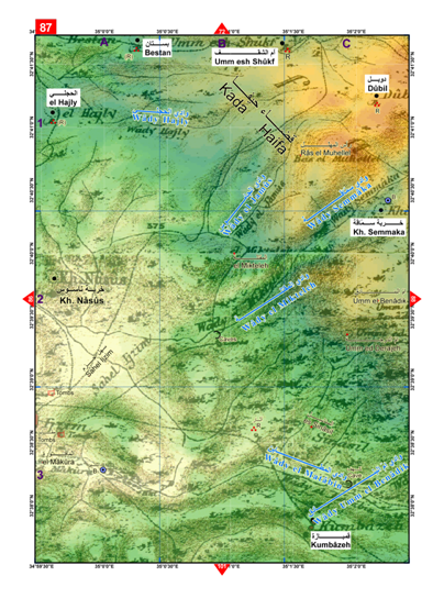
Fig-15a. Fig-15b.
 -->
-->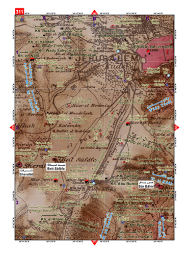
Fig-16a. Fig-16b.
The last two show the extra names obtained from Traces.
 -->
-->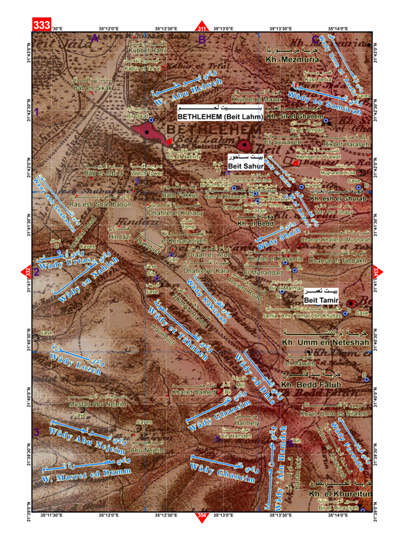
Fig-17a. Fig-17b.
 -->
-->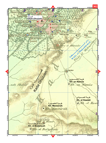
Fig-18a. Fig-18b.
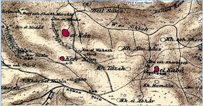
Examining the traces gave us a fresh look at the knowledge and the attitude of the surveyors in composing the Great Map. (Figure 19 - a, b, c, d) It seems they made a significant revision in London using the traces first, then notebooks and even their own judgments. Then they created composite maps. Finally, the Great map. The last map of this Figure shows a comparison between the published PEF map and our more accurate “Atlas of Palestine 1917- 1966”. It shows the differences in the accuracy of the terrain and place names.
 -->
--> 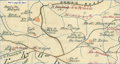
Fig-19a. Trace Fig-19b. Composite
 -->
--> 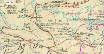
Fig-19c. PEF (Great Map) Fig-19d. Atlas of Palestine
Not only there were differences in detail among the various stages of the maps. The reproduction of maps from traces to the Great Map was also not complete. For example, in this trace, (Figure 20), road lines shown in a trace are not reproduced in the Great Map.
In the next map, (Figure 21), we show the details of the secondary branches of a wadi (light blue in the bottom) not reproduced in the Great Map.
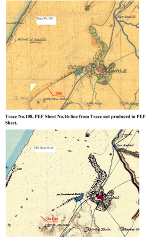
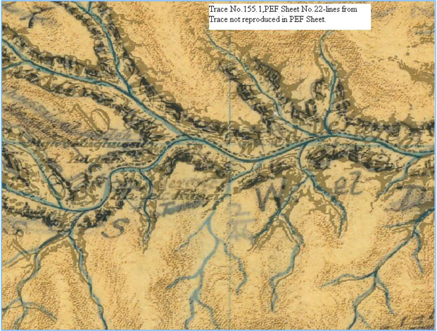
Fig-20. Top:Traces, Bottom:PEF Map Fig-21. Trace and PEF Map Superposed
In general, however, these are not important discrepancies.
- TABLES, Generated Statistics
The spelling of English and Arabic names needed close revision.
Table 4 (Figure 22)
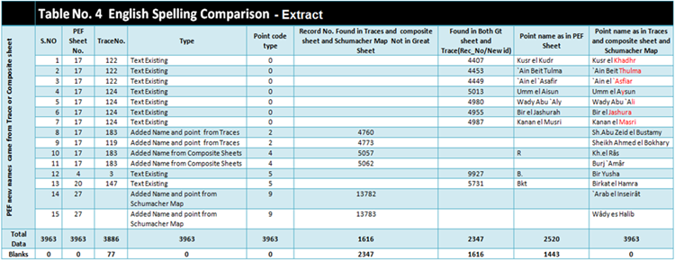
Fig-22. Table No.4 English Spelling Comparison - Extract
Names in English as transliterated in Arabic and entered in the Great Map based on the information gathered in the field.
This table shows the comparison between the names in the traces and in the Great Map. We completed the abbreviated names and corrected some of the others. We kept the English spelling of the Great Map for the most part as is, for historical reasons.
Table 5 (Figure 23)
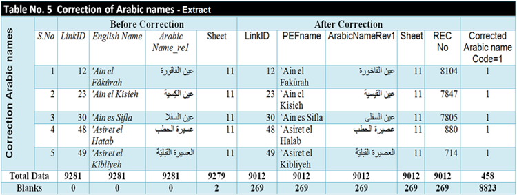
Fig-23. Table No.5 Correction of Arabic Names - Extract
Names in Arabic as recorded by E H Palmer (Prof of Arabic at Cambridge) in “Arabic and English Name Lists”. They were corrected into proper Arabic.
Table 3 (Figure 24)
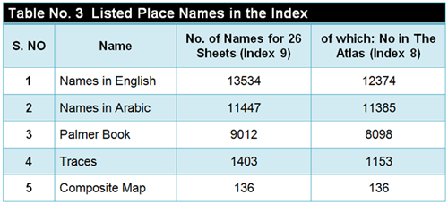
Fig-24. Table No.3 Listed Place Names in the Index
An Index
We created two indices. Index 8 for names appearing in Palestine territory which is our new Atlas and index 9 for the whole 26 sheets. You can also see the source of these names, whether from Palmer’s book (much less) or from traces or composite sheets.
Group Classification
All the names listed in the Great Map of PEF are about 9,000 (Memoir Vol 1 p. 36).
We listed 13,534 names altogether. This is about 3500 more names.
In PEF Legend Sheet, names and symbols are listed for 77 categories but they were not counted. We classified all points into 135 categories and listed them in 5 groups:
These are:
Group 1: Villages classified in 12 categories. Total 2525 villages or human settlements. There is a village every 3.5 km, which is roughly the distance travelled on a horse in one hour. This is a stark rebuttal of the myth that “Palestine is a land without people”.
In most archaeological reports the word khirbet in mentioned. It means an old place, inhabited then probably abandoned then inhabited. It was mentioned 1450 times (out of 2430 times in our Atlas of Palestine). The dominance of this name is a true reflection of the ancient history of Palestine.
Group 2: Place Names classified in 51 categories. Total 2555 names describing the terrain.
Group 3: Holy and Historical Sites classified in 19 categories. Total 1814. A typical village of an average size had one or two holy sites. Palestinians over the ages lived in the same place and when they changed religion, they maintained their reverence to the same holy sites. Thus, Palestine deserves the name Holy Land.
Group 4: Water Resources classified in 27 categories. Total 2600. This means that on average every village had 2 to 3 water resources. People depended totally on these water resources. They became a central part of their life, places of reverence, tradition, and folklore.
Group 5: Feature Points classified in 26 categories. Total 1075. They describe important buildings or landmarks.
Palestine was a society vibrant with life before its destruction in 1948 and after.
(Figure 25)

Fig-25. National Bird of Palestine
- COMPLIANCE WITH THE SURVEY MISSION
Now we can ask the question: Has the actual survey complied with PEF stated mission?
As is well known the mission of the survey was to collect information on
- Jerusalem would be a prime target. Biblical sites.
- Manners and Customs of the People of the Land.
- Topography
-
- Natural sciences: Botany, Zoology, Meteorology.
There is no question that the information collected in the maps and in the Memoirs about these topics is impressive. This applies mostly to the topography. Jerusalem was on the top of the list. The British Mandate could not change a line in Wilson’s map of 1865.
On archaeology, its verification required an excavation of which little was done. [1] Identification of sites in relation to the Bible was haphazard, more of wishful thinking than scholarly judgment. Wilson, the General Editor of the Memoirs noted that “Lt Conder’s exuberance leads him occasionally into remarks which are scarcely worthy of publication by this Society”.[2] Any way they tried their best.
On Palestine’s Fauna and Flora, the record is unequaled. We are indebted to Canon Henry Baker Tristram for his work. Tristram left us a beautiful rendering of this bird, named Sun Bird, or tameer filastine. Palestinians are particularly grateful for this rendering in 1884. The settlers in Palestine claimed the Bird is their national bird, presumably, they brought it with them from Poland or Siberia. After a long battle with Israel, the SunBird was recognized in 2015 as Palestine’s National Bird. The bird escaped the clutches of the Israeli occupation.
I assume we should now be at liberty to judge PEF survey by our state of knowledge today and by our accepted standards of human values. I admit this is a limitation, as we are talking of another century. But it is legitimate to examine the case whether the knowledge gained in the 19th century had shaped our present and our future for good or bad and whether we paid a price for it or we gained an advantage.
- CRUSADES’ SPIRIT
The first observation I can make, as a Palestinian, is the spirit behind the survey.
This spirit as observed was deeply influenced by the Crusaders who departed from Palestine seven centuries earlier. It looks as though their memory lingers on in the minds of the Victorian surveyors.
The opening page of the first Memoir is adorned with the image of a Crusade Soldier (Figure 26). It was not only an image. The PEF Memoirs are full of details about Crusade ruins, dates and descriptions of derelict place names. This minute search was not necessarily related to the Bible, which was the object of PEF survey. It was chasing the trails of the Crusade’s failing adventure to conquer Palestine. It seemed the survey was an attempt to revive the dead objects and dead memories.
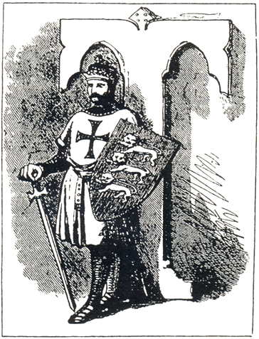
Fig-26. Image of a Crussade Soldier
Or was it an attempt to recreate it in the next few decades, as actually happened?
If there was any doubt about it, it was cleared by PEF President, the Archbishop of York, William Thompson, in his inaugural speech at PEF foundation: He said,
“This country of Palestine belongs to you and to me. It is essentially ours. …it is the land to which we may look upon, with as true patriotism as we do to this dear old England, which we love so much”.[3]
This is hardly different from the speech given by Pope Urban II, (27 Nov 1095)
800 years earlier, exhorting the quarreling Lords of Europe to wage the Crusaders’ war. He said,
“Set out on the road to the Holy Sepulchre [in Jerusalem], take the land from that wicked people, and make it your own”.
- THE PEOPLE OF PALESTINE
Who were those wicked people? Are they the people of the land, the Palestinians? Perhaps that was the reason practically nothing was said about them in the Memoirs. Those living people of Palestine, who filled the landscape in over one thousand localities, were not mentioned in the Memoirs. While the ruins of a single stone were measured, photographed and described in a dozen pages, the population of the district did not deserve one paragraph. Yet it was a requirement of the survey. There was absolutely nothing compared to Edward Lane’s The Manners & Customs of the Modern Egyptians, published 40 years earlier, which could have been an example to follow.
The only living creatures mentioned in the Memoirs were 20 natives carrying the luggage and 20 animals.
But the people were very much alive. In July 1875, Conder and Kitchener pitched their tents near Safad and started surveying. The people of Safad got suspicious of those foreigners measuring their land. Words like ‘Christian Crusaders returning’ were flying around. There was a quarrel, turned into a scuffle which ended with Kitchener bleeding in the head and Conder put out of action. The whole expedition was suspended for close to a year.
- MUSLIM SHRINES
The Crusaders spirit was chasing the surveyors. It silenced the mention of Muslim shrines. The survey recorded 400 un-named sites, listed as only tombs, graves, kubur, caves and the like without any identification. Comparing these same sites with our “Atlas of Palestine” we found that most of these incognito sites have well known and historically identified names of holy men attached to sites.
Now we come to the sad story of the Native Scribe.
- NU’MAN QASATLY
Under Arabic Nomenclature, the Memoirs (Vol 1, p 35 ) mentioned that the collection and writing of Arabic names were carried out by an “Arab scribe”.
I was curious about this un-known description.
I saw and scanned many of these Name Books, here at PEF Archives. I saw the beautiful Arabic handwriting, (Figure 27) which could not have been written by an Arabist like Charles F Tyrwhitt Drake. Somewhere tucked away, I found out the name Qasatly.
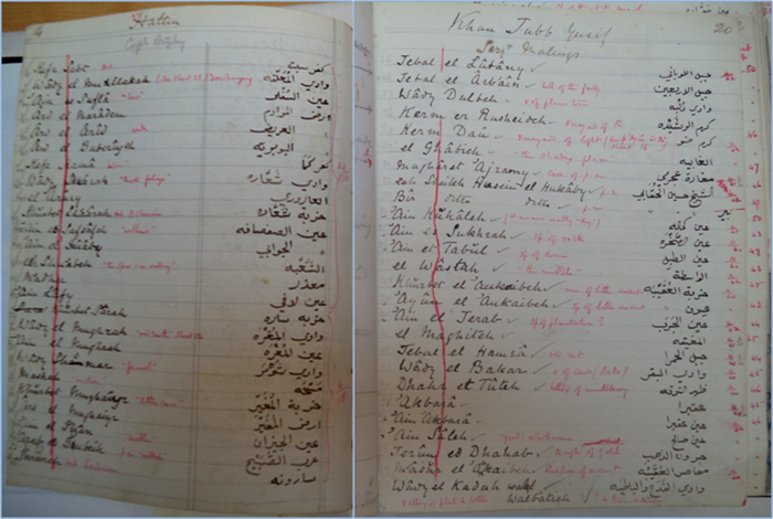
Fig-27. Qasatli Arabic Handwriting
I searched for him elsewhere and found his manuscript in the Manuscripts Library of the University of Jordan. I also found an MSC thesis about him at the University of Damascus in Arabic by Bushra Ali Kheir Beck, dated 1990, entitled “Palestine in the writings of Arab Travellers”.
Here are pages of the manuscript, (Figure 28a)
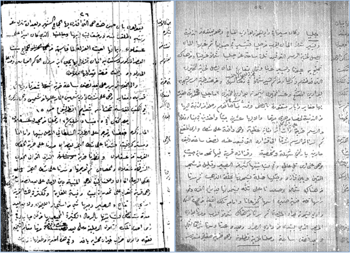
Fig-28a. Pages of the Manuscript
Lo and behold! It was the same handwriting!
This ‘native scribe’ was Nu’man ibn Abdu ibn Yousef Ibn Nicola Al Kibrany Al Qasatly, born in Damascus in 1854- 1920(. He was an accomplished geographer. He described the same survey sites of Conder and drew them. (Figure 28b- right)
He wrote several books. This is one of them (Figure 28b - left), on the archaeology of Damascus, Jerusalem (al Kuds) and Al Khalil (Hebron), when all Syria was one country.
Fig-28b. (left) Qasatli Book, (right) Monument Sketch
He was an accomplished novelist and poet. He was also a successful businessman.
That was so much recognition accorded to the “Native Scribe” in the Memoir.
- ERASING HISTORY
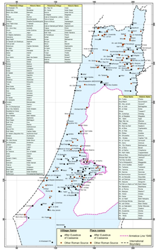
On a brighter note, the Biblical study had a great benefit for the Christian history of Palestine. Thanks to PEF, we know of the Palestinian Byzantine Bishop Eusebius of Caesarea who, in the year 313 AD, listed Palestinian localities and their distances for the benefit of pilgrims to Jerusalem. This valuable work was translated recently from Greek and Latin to English by PEF.
We made a study of the Bishop’s book. By comparison of names in his book with our Atlas of Palestine, we identified at least139 village names and 50 place names (Figure 29a), known to us from Eusebius book 17 centuries earlier. Here are their Byzantine names with the phonetically similar modern names and with the same names and locations that existed for 17 centuries, at least.
Possibly Jesus Chris walked in their streets. Many of these names are immortalized in PEF survey maps. They lasted until Al-Nakba of 1948 when Israel expelled their people and destroyed them. (Figure 29b). This is a huge loss to the heritage of humanity.
 -->
-->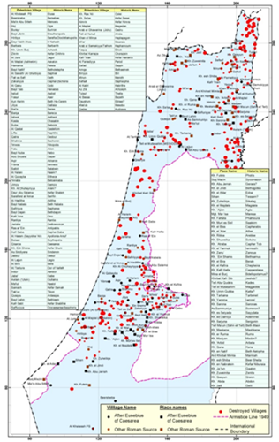
Fig-29a. Village and Place Names Fig-29b. Israeli Destroyed Villages
- Who Benefitted from the PEF Survey? Was it preserving the heritage of Palestine?
It has been stated in a PEF publication that the survey was “a story of national pride, religious devotion, military strategy, financial scheming, and personal ambition”.[4] The players were clergymen who wanted a scientific study of the Bible land, Evangelists in London Jews Society, the proponent of the Restoration Movement, whose mission was to send Jews to Palestine to convert them to Christianity or perish. Those were the public players.
But there was a major missing player. The elephant in the room was the military agenda of the survey. It was a thinly veiled secret. The main beneficiary was the Ministry of War.
PEF was chronically short of money. The Ministry of War came to its help at a price. They provided the survey officers, and enough money to complete the survey and print it provided it was not to be made public without permission. Later, the Ministry took over completely. By the beginning of the 20th century, PEF role was irrelevant in terms of men, logistics, and mission. PEF remained a convenient cover for military purposes.
The military agenda of the survey was prominent from the beginning. Quite early, it was observed (by Wilson -Editor) that ‘the map would be of great importance, as a military map, should… Palestine ever be the scene of military operations. [5]
This understanding preceded carrying out the Survey in Palestine. In 1869, PEF sent a Sinai expedition near Suez Canal, it was headed by Cambridge Professor E H Palmer, the Orientalist. He returned to Sinai in 1882, concurrently with the British invasion of Egypt. Due to his knowledge of Arabic and of Sinai tribal sheikhs, he was tasked with the mission to gain the sheikhs’ support for the British invasion of Egypt and to persuade them by bags of gold. His mission was cut short. He was killed and the gold bags disappeared. The first prototype of Lawrence of Arabia failed.
A young 22-year old officer by the name of Kitchener, second in command to Conder, did a geological survey with Hull in Gharandal, in Wadi Arabah and in Sinai to complete missing parts of the survey. His meteoric rise took him to be the Chief Commander “Sirdar” of the Egyptian Army, then he became the British Minister of War. He drowned in 1916.
The survey of south Palestine, wrongly called Naqab (Naqab is a corruption of the Hebrew term Negev, it has no equivalence in Palestine Geography), was completed in 1914, just before WWI, by Captain Stuart Newcombe. It was a military map, so detailed that it showed which roads were passable by vehicle or animals and the quality of water in the wells. According to Morrison, PEF Chair, “the map Newcombe prepared helped to secure an Allied victory in Sinai”.[6]
Nine years later, Newcombe, together with another colonial officer, the French Poulet, delineated the Palestine Lebanon Border in 1923.
T E Lawrence of Arabia started his military career with an intelligence operation in southern Palestine, to discover Turkish sites. His trip was disguised as PEF search for the Wilderness of Zin. He then went on to carry out his famous adventures in Jordan, as the ‘uncrowned King of Arabia’. His main achievement was the destruction of the Hijaz Railway line, built to carry pilgrims from Damascus to Medina. The project was financed by donations from Muslims around the world.
Schumacher, the German engineer residing in Haifa, reported on the Hijaz Railway plans and charted a detailed map of the Golan Heights.
All PEF map work made it easy for Allenby to conquer Palestine in 1917.
WWI battle maps were entirely based on PEF maps.
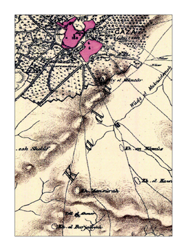
Here is (Figure 30 a) the map of Gaza as shown in the PEF survey.
This is the military map used in 1917 in WWI (Figure 30 b). You will notice the additional information added to identify buildings from early aerial photographs and information provided by spies. Gaza was bombarded relentlessly by artillery causing a great deal of damage to historical buildings.
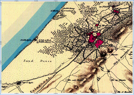
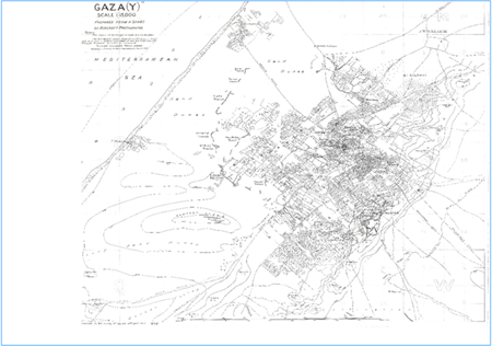
Fig-30a. Gaza - PEF Survey Fig-30b. Gaza - Military Map 1917
The British failed twice to breach Gaza defenses at a great loss in their dead and wounded. They failed although they dropped 1400 canisters of poison gas on Gaza. (Figure 31). Here are British soldiers training for it.
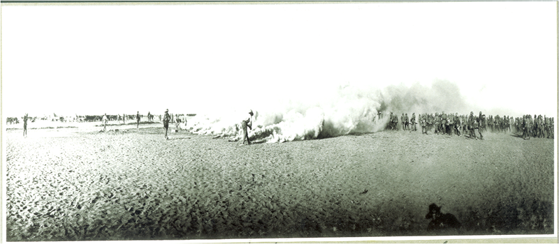
Fig-31. British Soldiers Training for Poison Gas Attack
Gaza suffering is a hundred years long.
The British changed plans. Instead of Gaza, they marched south at night through Wadi Beer Sheba and slept by day hidden in the wadi banks, till they circled Beer Sheba from the south and east.
They started the march from my land, marked Abu Sitta, in Allenby war map. (Figure 32). Possibly my mother saw the advancing troops. My father was away, meeting the Turkish Commander of Beer Sheba Garrison, Ismet Bey, to help in its defense. My father believed that Muslim lands should be defended by Muslims. He was against the British invasion of Palestine.
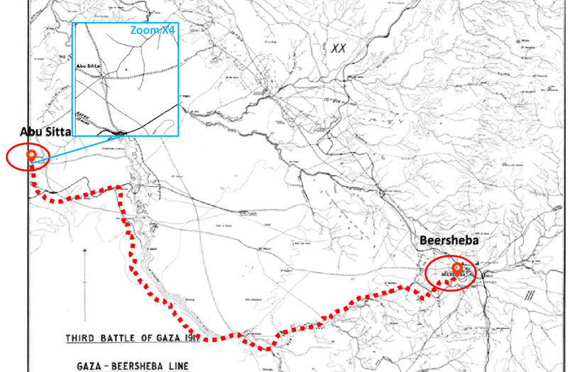
Fig-32. Beer Sheba Attack Route
Beer Sheba fell on 31 October 1917. When Allenby’s telegram reached London the next day, Balfour announced his infamous Declaration, on 2nd November 1917, handing over Palestine to the Russian Zionist leader Haim Weizmann.
A century of death and destruction followed. During this century, I and seven million Palestinians became refugees. They never wavered from demanding their legal Right of Return.
Let me digress a little here to tell you a historical note. After the Turkish defeat in Beer Sheba, the garrison commander, Ismet Bey, contacted his colleague, Mustafa Bey, the commander of the Turkish garrison in Nablus. They both concluded that the defeat was not because they were inept, but because the system of their government was defective. They both went back to Turkey and engineering a coup d’état. The Turkish Republic was born. Mustafa Bey or Mustafa Kamal (Ataturk) became the first president and Ismet Inonu became his successor, the second president.
History has its ways to teach us. Thirty years later and 30 km northwest of Beer Sheba, the same story was repeated. The Egyptian officer, Jamal Abdel Nasser, was besieged by Israeli soldiers in Faluja pocket. He reached the same conclusion about his country. He returned to Cairo and engineered with his fellow officers the plan to topple the 150 old Mohammed Ali dynasty. The Arab Republic of Egypt was born.
- COLONIZATION
What is the effect of PEF Survey on the colonization of Palestine?
PEF Survey maps do not have a single Zionist colony in Palestine. Palestine was purely Arab. There were, of course, Ottoman Jewish citizens in some Palestinian cities.
The age of actual colonization hit Palestine at the beginning of the 20th century under the banner of the British Mandate.
The first assault on PEF work was waged, surprisingly, by a British Official, Herbert Samuel, the first High Commissioner of Palestine under the Mandate. His mission was to bring independence and freedom to Palestine. Instead, as an ardent Zionist, Samuel undertook another mission, to convert Palestine into a Jewish state. Barely three months after his arrival in Palestine in July 1920, he sent a letter to London, requesting to erase Arabic names of 52 villages recorded in PEF survey maps. He wanted them to be replaced by newly contrived Hebrew names.
PEF maps were a boon to the Zionist colonization plan. Palestine was a densely populated land. See black dots. (Figure 33 - left). Where there were widely spaced villages, Zionist colonization found an opportunity to infiltrate the gap. (Figure 34). That was the case mostly under the British Mandate.
The settlers landed on the coast of Palestine, first at or near Jaffa. Some came in smugglers’ ships anywhere on the coast. Initially, they built houses in a suburb of Jaffa. They called it Tel Aviv. These colonies made the backbone of Israel. (Figure 33 - right zoom).
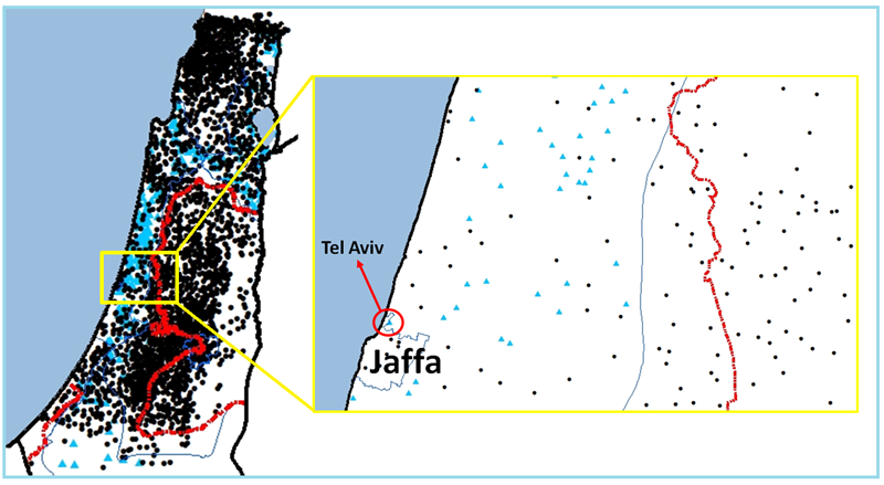
Fig-33. (left) Zionist Colonization (blue) in Central Palestine, (right) Jaffa - Tel Aviv Detail
These settlements were too few for the Zionist goal. In April 1948, the Zionist invasion of Palestine took full force. The UN Partition Plan proposing to give more than half of Palestine to the Zionist settlers was abandoned by the UN as unworkable “without bloodshed”. The US concurred. Instead, the UN proposed a UN trusteeship to replace Britain. The Zionists decided to launch their plan of invasion of Palestine, code-named Plan Dalet. (Figure 37).
Fig-37. The Zionist Invasion of Palestine (1 April - 14 May 1948)
Within 6 weeks, from 1 April to 14 May 1948, the Zionist army (the Haganah),
attacked and depopulated 220 Palestinian cities and villages, thus creating half of the Palestinian refugees. This took place before the British left Palestine and before Israel was declared as a state. The Zionist army was composed of 120,000 soldiers, many were WWII veterans, organized in 9 brigades. They conducted 31 military operations. The expulsion of Palestinians from their homes was propelled by more than 5 dozen massacres.
On 14 May 1948, David Ben Gurion declared Israel, his settlers’ state in Palestine.
On this day, my land was attacked by the Haganah, our homes were burned and destroyed. And I became a refugee.
In the densely populated areas, especially in the hilly areas, now called the West Bank, Zionist colonization was difficult to take root under the British. The only way to plant colonies there was by military conquest, which took place much later, in the Israeli war of 1967.
Now, colonization in the West Bank is carried out publicly, contrary to international law. Under the Statute of Rome, settlement in the occupied territory constitutes a war crime.
Trump’s Deal of the Century (2020) is the latest war waged against the Palestinian people, started by Balfour in 1917, to destroy Palestine and Palestinians.
Will they succeed?
- SO WHAT DOES THE NEW ATLAS OFFER?
With the publishing of this PEF Atlas which we are presenting today, the record of Palestine before the Zionist colonization is preserved.
This preservation is no small feat. In the whole history of colonization, there has never been such massive destruction of a country as in Palestine. People of the country were depopulated. Its urban and rural landscape destroyed. Geographical records of its place names erased. Two thousand years of Palestine history were reduced to a blank page. All of this was replaced by a fake narrative.
On the small scale of archaeology, the loss of Palestinian names is a loss to human heritage. This loss inflicted amnesia on two hundred years of archaeological research, which used Arabic Palestinian names to identify places of excavation.
How could a young researcher today find Wadi El Hesi, where Flinders Petrie carried out his remarkable work? Or how could he find Tel es-Sultan where Dame Kathleen Kenyon did her work? How could he find Tell al Far’ a and Tell Jemma where the Australians recovered mosaics of Byzantine churches of the fourth century? How could he find the many places recorded by P J Baldensperger and Gustaf Dalman about life in Palestine?
All these places were solely identified by their Arabic names. Their erasure obliterated the history of archaeology.
- CONCLUSION
But the loss is much greater than that. A great historical country like Palestine is destroyed in reality and on record. Its people are now 13 million, dispersed in the world, while half remained on the soil of Palestine under an Apartheid and racist regime. Can it last?
We publish this new Atlas of Palestine 1871- 1877, one hundred and fifty years after PEF Survey, to bring this historical and geographical record to life again and reverse the erasure of Palestine’s heritage.
In this work, I have been motivated by the mission to restore Palestine -- to chart the passage of Palestine from its beauty and tranquility in 1870 (Figure 38 a)
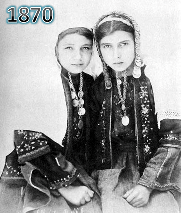
Fig-38a. The Past
through its tragedy in 1948, the on-going Nakba, (Figure 38 b)
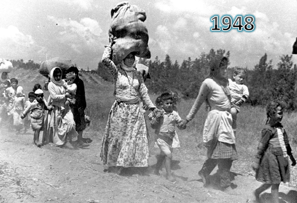
Fig-38b. The Present
And BACK in the near future, to a new Palestine, restored to its normal life (Figure38 c), full of freedom, peace, justice, joy, and happiness. Just as PEF surveyors found it.
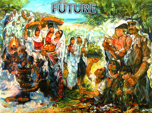
Fig-38a. The Future
Let us work together so that Palestine will recover its geography and history again, sooner rather than later.
Endnotes:
[1] Nadia Abul Haj
[2] Hodson p 53.
[3] PEF/MINS, 22 June 1865, Thompson was President of the PEf from 1865 to 1890.
[4] Hodson p 33.
[5] Hodson p 37
[6] Moscrop p221.
[2] Hodson p 53.
[3] PEF/MINS, 22 June 1865, Thompson was President of the PEf from 1865 to 1890.
[4] Hodson p 33.
[5] Hodson p 37
[6] Moscrop p221.