| Speech Venue and date |
| Exeter University, November 11, 2010 |
London Westminster, November 12, 2010 |
| Southampton University, November 13, 2010 |
Manchester University, UK, January 17, 2011 |
| Cambridge University, UK, January 19, 2011 |
Washington, DC, April 28, 2011 |
| Los Angeles, April 30, 2011 |
San Francisco, May 3, 2011 |
| Houston, May 4, 2011 |
Cleveland, May 5, 2011 |
Introduction
You must have read in history books the story of the king who conquered faraway lands, brought back riches and immortalized his deeds by carving them on a stone monument. Then the next king chipped off his name, put his name instead and claimed to be the victor. This forgery and deception are still going on today, only with more sophisticated spurious scholarship and shady ideology, assisted by modern technology.
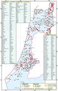
Now we do not have stone monuments. We have charts and maps. The map is long considered to be the birth certificate of a place or the certificate of its identify and its owner. In the last two centuries, maps became an instrument of colonial powers to show the extent of their conquest and domination. It was equivalent to planting a flag on a new territory and claiming its ownership. In the late 19th century the British Empire could boast vast dominions and showing it by painting pink colour over three quarters of the world map.
But nowhere in the world have maps been instrumental in the conquest of a territory than in Palestine. In the 19th century Palestine was blessed, and at times cursed, with so many travellers, priests, surveyors, spies and adventurers who charted the holy land. A particularly remarkable effort in that century was the work of the Palestine Exploration Fund (PEF) in which they conducted a full survey of Palestine for 4 years starting from 1871. The result was charted in 26 sheets and 10 volumes showing 12,000 place names. Although its purpose was to verify the authenticity of the Bible and had little interest in the living people of Palestine, it remains to be the most important record we have today of 19th century Palestine. All this mapping was vital for Gen. Allenby’s campaign to occupy Palestine in 1917. Two years later, the Zionists, promoting the myth that Palestine was a land without people and ignoring the well-documented PEF survey, presented, with great audacity, to the Versailles Peace Conference in 1919 a map of Palestine, hatched over its 1,000 towns and villages, and covered with the words “grazing for nomads”. That was their first brazen forgery. More were to come.
This month ushers 93 years of death, destruction and destitution of the people of Palestine resulting from Balfour Declaration, the promise of those who do not own to those who have no title. Yet while Allenby was fighting in Palestine, Haim Weizmann, on behalf of the fledgling Zionist movement, pressured Britain to survey every acre in Palestine to identify any plot which can be given to Jewish colonization. The British complied and the Survey of Palestine was established which provided us with a wealth of information. Contrary to Zionist aims, it gave us absolute proof of the falsehood of Zionist claims. Palestine Survey is what this Atlas is about.
Colonial powers, influenced by Zionist pressure, carved out the boundaries of Palestine, to isolate it from the Arab East and giving it away. Their surveyors went around Palestine, plotting, marking and dividing lands. All these boundaries were delineated without the knowledge, let alone the consent, of the people of the land. Those people suddenly found themselves cut off from their relatives, their water, their fields and their livelihood by a border created and guarded by foreigners.
The Colonial Powers intended to create spheres of influence, to utilize natural resources and build military bases. However none of them intended to dispossess or expel the population of the land, or to confiscate their land and property. Zionism has totally different objectives. They were:
- To occupy and confiscate the land of Palestine.
- To expel its population and dispossess them.
- To erase their memory, their records and their trace from history.
The third objective, erasing the record of the Palestinians, received relatively little attention. It was primarily carried out through maps and also through re-edited historical books and propaganda films. It was a continuation of the military war to conquer Palestine. It should not therefore be surprising that Ben Gurion, in July 1949, immediately after signing the last Armistice agreement with an Arab country, Syria, formed a committee of geographers, historians, surveyors, theologians, and officers in order to erase all Palestinian names and to replace them by what was then thought to be Hebrew names or Hebraic names. That was an audacious effort in order to show that Palestinians did not exist and hence they have no history in Palestine. The Atlas of Palestine 1917-1966, published this month, is an attempt to restore the history and geography that was meant to be erased. In this presentation we can go through this unusual and unique experience of dispossession and obliteration of people’s existence. The following maps are taken from the new Atlas.
Slide-1
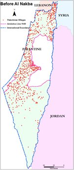
Here is Palestine which Allenby forces found when they occupied it in October 1917. It is a country with variable terrain; fertile coastal plains, cultivated mountains and Al-Ghor deep below sea level. It is the home of Palestinians for several millennia.
Slide-2
It also have enough water to sustain its people for centuries. These are the wells in Palestine. [Slide-2A] Also on the mountain side there are a lot of springs. [Slide-2B] There are also other water resources [Slide-2C] People worked on their fields and lived peacefully for many centuries. That was not a grazing land for nomads.
After 30 years of British Mandate, Jewish population increased from 9% of the population to 30% under the aegis of the British Mandate which allowed Jewish immigration to Palestine.
This is Palestine which Allenby came to occupy. [Slide-3] The Zionist managed to buy lands due to the British changes in land laws which allowed them to acquire land. The extent of the land they acquired by the end of the Mandate is shown in this map. [Slide-3A] It did not exceed 5% to 6% of the area of Palestine. At the end of the Mandate, the Partition Plan was proposed by the United Nations and this proposal was endorsed by the UN under severe US and Zionist pressure. [Slide-3B] The legal meaning of Partition Plan is that it is a recommendation which is only acceptable and enforceable if both parties agree to it. Of course the Arabs were not going to agree to surrender 95% of their country. The Partition Plan gave the Zionists sovereignty over 55% of Palestine, which is 11 times the area they owned. That also meant that 457 Palestinian villages and towns suddenly found themselves under the sovereignty of a new rule of Jewish European immigrants to Palestine who had just landed there. The Partition Plan never envisaged an ethnic or a religious state, nor could it do so under international law. It was merely proposing dividing the land between two governments with no dispossession of people. [Slide-3C] As it happened the Zionists were not satisfied. They actually occupied 78% of Palestine, which meant that 24% of Palestine was occupied over and above the Partition Plan.
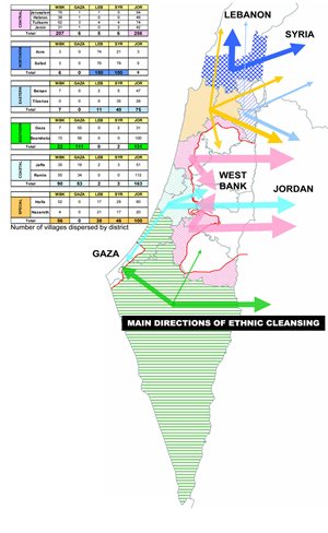
The Zionist started to occupy Palestine in stages [Slide-4] As you can see, this has taken place in several stages through 31 military operations. The anatomy of this Israeli conquest of Palestine can be seen in this chart. [Slide-5] The British were in Palestine supposedly to protect the civilians and ensure the integrity of Palestine as one country. The Hagana forces managed to expel half of the total refugees of Palestine while they were supposedly under the protection of Britain. And that was before any Arab regular soldier set foot in Palestine to defend its people from the Zionist invasion. Let us remember that those dispossessed population, before the Proclamation of the state of Israel, were victims of the first phase of the massive ethnic cleansing operation which lasted for so long. Ben Gurion, in fact, expelled the Palestinian citizens of the state he was to declare on May 14. After May 15, the expulsion of the Palestinians continued. A total of 800,000 people were expelled. They now number over 6 million refugees. If we look at this diagram carefully we notice something peculiar; it is that every depopulation of a village was concurrent with an Israeli military operation. When there was no military operation, during the truce period (shown in yellow), nobody left their homes. In order to encourage them to leave faster, massacres were committed during each military operation. We list about 70 massacres which took place in order to propel people to leave their homes. With this diagram, we can lay to rest the Zionist myths: that they were in self defense, that refugees left on their accord and that there was no ethnic cleansing.
[Slide-6 A, B] You can see that most of these massacres are in Jaffa-Jerusalem Corridor, in the coastal area and in Galilee.That was a stark ethnic cleaning of the people of the land. It is still continuous today.
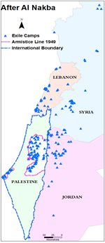
So here it is then. About 1,000 Palestinian population [Slide-7 A, B, C] lived peacefully in their land and then, within few months of 1948, (next) life has been extinguished from 675 ethnically cleansed villages. And where are they? (next) they were expelled to the areas remaining in Palestine, namely Gaza, and West Bank and neighbouring Arab countries.
The method of expulsion was systematic. A village was surrounded from three sides leaving one side open towards the area to which they were expelled. [Slide-8] In the north the open side was towards Lebanon and Syria. In the centre, to the East, towards Jordan and west bank. In the south towards Gaza and to Jordan. This was the largest organized dispossession in modern history.
-
 Slide-7A
-
 Slide-07-B
-
 Slide-7C
 Slide-8
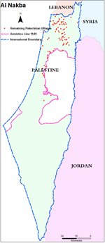
After cessation of hostilities, Armistice agreements were signed and the Armistice Line was delineated according to various Armistice agreements. It must be noted that the Armistice line is not a border. Article-2 of the Armistice agreements clearly says that this line has no legal meaning; it does not confer or deny any rights or claims of any party in any territory divided by the line. It is common to call this line the Green Line, according to the Israeli usage. This application is meant to obscure its legal meaning; that it is an Armistice Line which has does not give the Israelis any legitimacy of the land on either side of the line.
 Slide-9
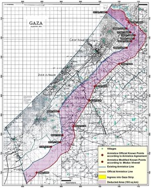
Now Israelis were not content to take 78% of Palestine. They tried everywhere to bite into the remaining Palestinian land and take over some more land. [Slide-9] Perhaps you all know how crowded the Gaza Strip is. It is where the population of 247 villages was pushed out of their homes to exile in refugee camps. But probably very few know that the original Gaza Strip has an area of 555 sq. kilometers, larger than the present one. This is the line that was determined by the Armistice Line of 24 February 1949. However the Israelis harassed the Egyptians and actually cheated them in a number of ways, so they convinced them to sign a secret, supposedly temporary agreement, called Modus Vivendi, one year later, in February 1950, in order to be able to control the Armistice Line better. As a result, this temporary blue line was agreed. But it turned out that this line became permanent and this red area, about 200 sq. kilometers, have been stolen from the area of Gaza Strip. [Slide-10]
 Slide-10
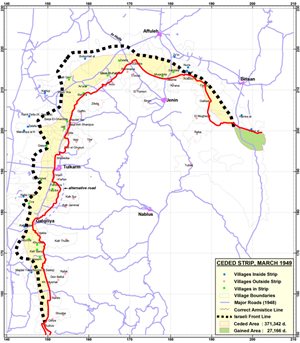
The same thing actually happened in central Palestine in the spring of 1949. [Slide-10] The Israeli military line corresponded to this black dotted line. The Israelis literally blackmailed King Abdallah of Jordan and threatened to occupy the whole West Bank, if he doesn’t concede a big chunk of the West Bank. As a result, the final drawn line became like this, capturing an area equal to Gaza Strip where 100,000 Palestinians lived and who are now Israeli citizens. The bad luck of the Israelis is that one of those citizens is Raed Salah, the defender of Aqsa Mosque.
 Slide-11
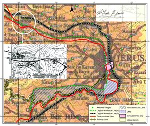
This blackmail and extortion was also practiced in Jerusalem area. [Slide-11] This dotted green line was the first agreed line of Armistice around Jerusalem. The old city and the villages to its south and east were to remain Palestinian, including for example Beit Safafa, Walaja. But the Israelis pressured and threatened the Jordanians to agree to another line which is (the red line) now in current use. But this line confiscates the land of Walaja and Beit Safafa and put the railway line from Jaffa Jerusalem in Israeli territory. By extortion Israel annexed the blue area.
 Slide-12
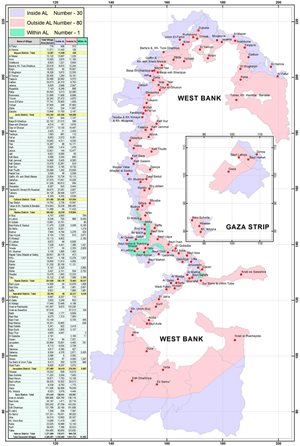
As a result, Palestinian villages in the West Bank and Gaza are dissected by this line, forcing separation of families, their water resources, or the village houses from the school or mosques or the fields. A total of 111 villages have been dissected like this. [Slide-12] Their life has been shattered by this arbitrary line.
Needless to say that, after 1967, the whole of the West Bank is under brutal occupation and bounded by Apartheid Wall and that Gaza Strip is strangulated under siege.
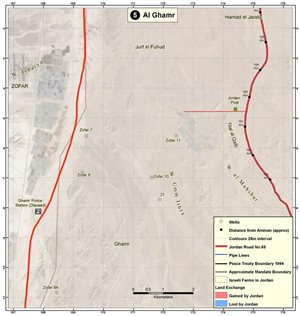
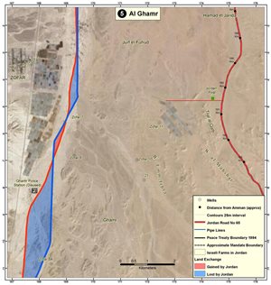
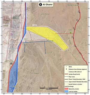
Not surprisingly, the Israeli practice of creeping confiscation of land went on, even after turning the Armistice agreement into a Peace Treaty, such as the case with Egypt and Jordan. We know the case of Taba which Egypt won by arbitration. In the case of Jordan the Israelis trespassed into Jordanian territory up to the length of 10 km and a variable width of half to 5 km. Jordan had to accept annexation of some of its lands to Israel against theoretical compensation of Palestinian land in Israel. [Slide-13] This red line to the left shows the Mandate boundary. According to the Peace Treaty this blue area was lost by Jordan and gained by Israel. This is not the only point. Israeli pressured Jordan to accept drawing of Jordanian water from about 12 wells inside the Jordanian territory up to 10 million cubic meters per year and to keep the farms’ area of 30 km2. (yellow area). This map was never published in Jordan. The Treaty calls for compensation of this water for Jordan from other Israeli sources. But it is not clear whether this compensation took place or not.
Now after 1948 Nakba, Ben Gurion found that he has now a huge area of vacant land, (93% of the State is Palestinian) and hundreds of thousands of empty houses. So what could he do with it? At that moment it was too soon to bring Jewish immigrants quickly enough to occupy the emptied land. The first thing they did was to loot all these properties. There was a “frenzy of looting” according to the Israeli writer Similansky.[Slide-14]
-
 Slide-13A
-
 Slide-13B
-
 Slide-13C
-
 Slide-14A
-
 Slide-14B
The first group of looters was a nearby Kibbutz or Jewish neighbourbood. They descended upon Arab homes in towns and found a hot meal in the kitchen, a child’s toy or unmade bed. They picked everything they could carry. They ripped windows, doors and tiles. The next group of looters was the Army. After finishing the task of expelling Palestinian farmers, they turned their trucks and loaded them with plundered goods. According to Ben Gurion, Battalions loaded 1,800 trucks from Lydda alone. The next group of looters was the high ranking members of the ruling Mapai party. They competed for the choice Jerusalem stone-houses or villas. The next looters were Jewish businessmen. They met in Haifa and decided who would take what of Palestinian factories, workshops and stores. The next looters were the institutions. The Hebrew University looted private libraries in main cities, still held there under the name: National Library.
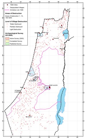
But the biggest looters were the Jewish National Fund and the Jewish Agency. They took over all remaining houses and lands. First they had to demolish all villages in coastal villages, Jaffa-Jerusalem corridor, to prevent the return of the Palestinians and had to remove or hide debris to avoid what they called “embarrassment before foreign visitors” along the main highways. Then they found that the rich Palestinian history may contain artefacts of value to be used to create a Jewish history. So they formed an archaeological society to examine villages before destruction and to retain what was considered useful to the Judaized history. This learned academic society would receive a list of villages to be destroyed. The society would mark the places to keep and the rest was destroyed instantly, particularly the Byzantine, Arab and Islamic monuments.
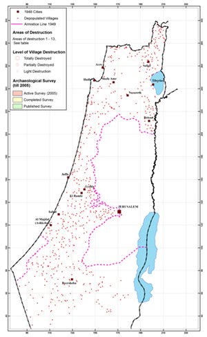
This large scale demolition caused a major and irreversible loss to the heritage of humanity. [Slide-15] In the year 313 AD, the Bishop of Caesarea charted the names and location of Palestinian villages. From his record, we identified 139 villages, bearing the same old name with slight derivation, which existed for 2,000 years until 1948. [Slide-15A] We also identified another 50 historical sites (Khirbets) still in existence till 1948. [Slide-15B] Israel physically destroyed most of those 2,000-year old villages and erased those historical sites from the map. [Slide-15C] All relevant international conventions strongly prohibit the destruction of human heritage.
-
 Slide-15A
-
 Slide-15B
-
 Slide-15C
-
 Slide-15D
Take the case of the old city of Tiberias. [Slide-16] Israel destroyed it and with it, a precious 3,500 year-old stone lion relief was gone forever.
 Slide-16
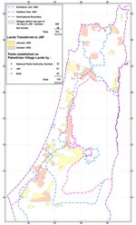
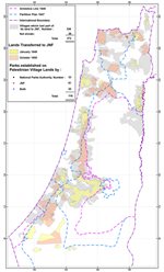
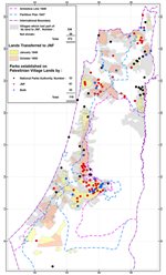
Now let us focus on the big looters and destroyers. They maintain 55 offices around the world, especially in Europe and USA, and are registered as tax-exempt charity. Their board members include leading Western politicians. Here in Britain they include Tony Blair. I mean of course the Jewish National Fund, [Slide-17] Immediately after Nakba, JNF confiscated 2,500,000 donums, belonging to 372 Palestinian villages. [Slide-17A] These were destroyed and forests and parks were planted [Slide-17B] on their ruins. These forests served 2 purposes: the first, they were named after those western politicians who aided Zionist occupation of and the second the forests were used to hide the remains of the buried villages.
-
 Slide-17A
-
 Slide-17B
-
 Slide-17C
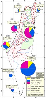
All this expulsion, looting and destruction took place in the land of Palestine occupied by Israel in 1948. So what happened to the expelled people of Palestine themselves? They are scattered (11 million in total) in Palestine in region around it. 88% of them are still within a narrow ring around it. [Slide-18] It is clear that, after all these years, Palestinians are not going to disappear and will never give up their right to return home.
Their determination to return home is not a dream or wishful thinking. It is not an illusion, as an errant UN official said two weeks ago. But they need a plan. International law is behind them. So are most of the world countries, with the exception of USA and some subservient western leaders. If international law is implemented, as it was in most similar cases, could Palestinians feasibly return and live in their homes as free men and women? Let us try to answer this question.
 Slide-18
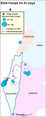
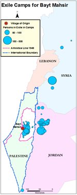
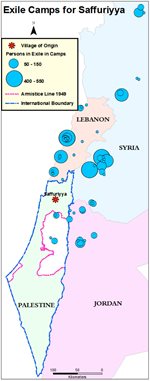
Palestine land and Palestinian refugees are one of the most documented in the Middle East. For example, we know where the people of al Jiyya village in southern Palestine [Slide-19] are residing now in exile. They are in refugee camps in Gaza and Jordan. We know where the people of the village of Beit Mahsir, west of Jerusalem, [Slide-19A] are exiled. Naturally they are mostly in the West Bank and Jordan. We also know where the people of Saffuriyya [Slide-19B], in Galilee, are residing. Most are in Syria and Lebanon. And so it is possible to draw a plan for the return of the refugees.
-
 Slide-19A
-
 Slide-19B
-
 Slide-19C
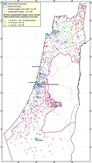
Can we rebuild the destroyed villages? Does that mean that we have to destroy Israeli construction as they did ours? We may find the answer in this slide. [Slide-20]
From that you will find that 90% of the village sites are still vacant today. Out of 560 depopulated villages–red dots, only 15 have their sites in the middle of new Israeli urban expansion after 1948, shown in blue. A further 22 village sites are near such expansion. All the rest of sites are entirely clear and ready for reconstruction.
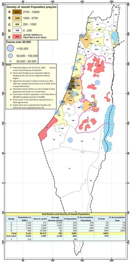
A further proof of that is shown in this map showing Jewish distribution in Israel. [Slide-21] It shows that 84% of Israeli Jews live in 17% of Israel’s area. They still live in these same areas which they acquired during the British Mandate. They are mostly urban. They shunned agriculture and rural life. Kibbutz members are only 2% of Israel population. Other than this small congested urban area, the rest of the country is used entirely for military purposes.
-
 Slide-20
-
 Slide-21
What would the returning refugees find in their home district? We classified the present occupants into 5 categories:
- Palestinians who managed to remain at home.
- Ashkenazis who conquered the country in 1948.
- Jews from Arab countries who were brought in the 1950’s to fill the void after the expulsion of Palestinians.
- Russians who immigrated en masse for about 5 years, starting from 1989, after the demise of the Soviet Union.
- Assorted European and American Jews who came intermittently, particularly after the 1967 occupation of the West Bank, Gaza and the Golan.
At the same time, we examined the Palestinian population of 675 ethnically cleansed towns and villages. We traced their home villages and their exile camps using the records of UNRWA. Accordingly, it was possible to estimate the existing and returning population.
-
 Slide-22A
-
 Slide-22B
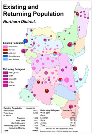
Take the Northern District, where a sizeable percentage of population is still Palestinian. [Slide-22] This shows both the present population as divided in these 5 categories. So what would happen when the refugees return home? [Slide-22A] There does not seem to be a problem of over lapping or crowding. About 800,000 refugees can return to live in their homes with their kith and kin, who already comprise half of the existing population. The trip is only a bus ride away.
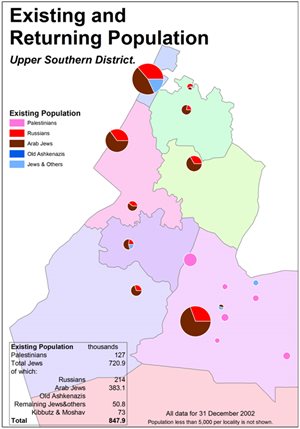
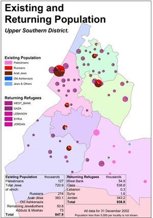
We can repeat the same exercise in the Southern District, which is actually much less of a problem. [Slide-23] shows the existing population classified as in the Northern District. With the exception of 3 originally Palestinian towns, now inhabited and expanded by Jews, and some other small “development” towns, all the rural Jews in this area (73,000) hardly fill one refugee camp in Gaza. The returning refugees [Slide-23A] are almost the same number as the present settlers, 800,000 each. The refugees can literally walk home.
So what do we need to carry out the long-denied justice and end the tragic suffering which continues, so far for 6 decades? We need to demolish racism and Apartheid and restore Justice.
Now I have final two observations, both created by the advent of modern technology used in this Atlas.
The first is this: We do not need to refute the Zionist myth that Palestine is a land without people. We do not even need to scour world libraries for our land deeds, which are all stolen by Israel.
-
 Slide-23A
-
 Slide-23B
We just need to turn to the people themselves, the Palestinians, who carved for themselves over the ages, and without pretention or plan, the vocabulary of their social history. This vocabulary, this massive record created by the life of the people for thousands of years, is now immortalized in 40,000 place names, genuinely crafted by the people themselves, and recorded in the Atlas. Here are some of them. [Slide-24]
We classified them as follows:
Most of the studies which have taken place about Palestine history have been concerned with the names of towns and villages. That is in order to examine the veracity and authenticity of the Bible. Village names in Palestine often refer to the families which inhabit them. There are 120 names with the prefix name: Bayt, that is the house of such and such. There are 51 names which start with Kafr meaning the village of a clan. There are 2,500 localities with the name khirbet, that is a hamlet or a ruin of an older place, which was or still is inhabited, but recognized all along.
However the life of the Palestinians is recorded not only in the names of these localities and their religious sites but also in a new category of names which hardly had been studied ever, or even recorded in one volume, except this one, although they constitute by far the largest number.
-
 Slide-24A
-
 Slide-24B
-
 Slide-24C
These names honour family; they refer to Abu, Umm, Ibn, Bint, almost 3,000 times, in relation to a place with particular features, such Umm esh Shuqaf, the place with pottery ware. They indicate ownership; Ali garden, Hussein field. They indicate planted fields; olives, grapes, figs. They indicate places where animals are common, horses, camels, gazelles, wolves, foxes. Or birds; hamam, pigeon, falcons. They indicate colours of the land; red, yellow, or terrain; tell, cliff, meadows. They indicate wells, springs and ponds. They indicate trades, such as pottery factory, grapes press, wind or water mill. They indicate the background of the farmer, Akkawi, Ghazzawi, Durzi, Nasrani. They indicate the relative location of the village; upper, lower, inbetween, (tahta, fauqa, bein). They indicate special events; the horses’ birthplace, the killing site of the chief, the hanging site, the battle scene. They indicate strange names such as; going up and down طالع نازل, the good name طيبة الاسم, good morning صباح الخير, the morning star نجمة الصبح, shield protector حامي قرصه, wolf’s face وجة الذيب, dog’s tale.ذنب الكلب
All these 40,000 places have names of people, created by people, for people’s recognition and use. It was their life etched in their use and speech. That is what Ben Gurion wanted to destroy. He must have turned in his grave if he knew that all such heritage that he erased was now restored. What did he want to replace it with?
The official Israeli Gazette produced, after arduous work, only 6,800 names. These were names of Israeli settlements in Hebraic fashion, names of some remaining Arab villages and names of prominent mountains and rivers. The Israeli names are short of Palestinian names by 33,000 names. Why? Because Israelis have no such history of the land as that of the Palestinians. They are the newcomers and the Palestinians are the true owners of the land.
The second observation I would like to make is also about Ben Gurion. It is claimed that he said, “the old will die and the young will forget”. Well, the old did die but not before they passed the message to their children. They told them about their village, their fields and their life. The children did carry it all over the world with more articulation and skill than their fathers ever did.
Now I have a gift for father and son. The father can show the son and the grandson his village and land with no fear of forgetting. Both will take a helicopter ride and fly over the village and the father will retell the same story with one difference. It will not fade away with time. The son’s children can see it again and again. Now fasten your seatbelt.
Video: 247 Gaza district villages totally ethnically cleansed and totally destroyed make up Gaza Strip
As I started with the story about the defaced monuments we realize that truth may be hidden or distorted. But it always has a way of coming back. It does not die easily. So is justice. Justice has a long life. If destroyed or burnt into ashes, it rises again from the ashes, like the Phoenix, to haunt the murderer, the robber and the unjust.
I am sure that truth will shine again and justice will prevail. As a believer in the human spirit which refuses to surrender to evil deeds, I am sure that the Palestinians will surely win and achieve the most basic human right: to return home.
- 1,500 names of human settlements, i.e. towns, villages, hamlets and tribal lands.
- 16,000 names of religious or historical sites, such as mosques, churches, maqams, shrines, cemeteries, burial places, wells, springs and other land features.
- 30,000 place names covering almost every acre in Palestine.