Source: BDS Movement
In the past few months, we have heard the news about the destruction of Al-Araqib village in the district of Beer Sheba in the Naqab by hundreds of Israeli patrolmen and their weapons of destruction (see Chapter-6). The monstrosity of the destruction and the arrogance of the Zionist invader are likely what propelled this piece of news to the front pages, although the process of destruction and expulsion of the indigenous Palestinians of Beer Sheba has been ongoing during the past few decades.
This news coincided with the case that was published in Israeli newspapers, which is the lawsuit filed by Nouri Al-Uqbi (68 years of age), the head of the Association for the Protection of Bedouins’ Rights in Beer Sheba, before the Beer Sheba court, to recover his land that was plundered by the Zionist invader.
This case however has not adequately grabbed the attention of Palestinian and Arab officials, even though the lands seized by Israel in the district of Beer Sheba exceed the area of the entire West Bank, and despite the fact that the expulsion of people from their homes and the destruction thereof, along with killing their livestock and spraying their farms with deadly pesticides, all mean that the Nakba of 1948 is still present and implemented in Beer Sheba for all to witness until this day.
The pretext put forth by Israel to the courts is extremely racist. It states that these lands have no owner, and are therefore lands of desolate barren wilderness (“mewat land”), and that there possibly could have been some shepherds who came from Saudi Arabia to graze their sheep and then returned.
The concept of the land being a wasteland void of an owner (also known as “Terra nullius”) is a longstanding colonial principle which was implemented by the English in North America, Australia and several parts of Africa. This principle is now discredited and has been withdrawn from circulation after two to three centuries of colonialism, in a shy acknowledgement of the crimes of the West in those regions.
The insolence of the Zionist organization reached such a point that in the Paris Peace Conference of 1919, it presented a map of Palestine–to justify approval of the Balfour Declaration–and had added hatched lines onto the map covering areas with the text “Grazing Land for Nomads”, thereby expunging approximately 1000 Palestinian towns and villages, most of which are two thousand years old or more. Yet this forgery paid off, as the League of Nations agreed to grant a mandate over Palestine to Britain, inclusive of the Balfour Declaration.
So is the land of Palestine a deserted wilderness with no owner? Can Israel consider any piece of land within Palestine a barren wasteland (mewat) if there is no title deed or registration for this piece of land in the Lands Department? In other words, does the Israeli rule apply, which states that all of the land is barren unless definitely proven owned and registered otherwise? Israel has implemented this rule, not only on the lands of Beer Sheba, which Britain did not register because of its hurried departure without implementing its responsibilities on Palestine, but also on many lands in the Galilee region and the area known as The Triangle in lands lying between the villages such as rugged terrain and the lands of Al-Hima. It still applies this rule extensively throughout the Occupied West Bank which it considers as lands of the state and implants settlements therein.
If we were in Palestine prior to the Balfour Declaration, or if we were in Jordan, Syria or Lebanon, we would not need proof that the land is Arab land owned by its inhabitants because of their long term usage of it and their customary convention, whether or not the land was registered and whether it was individually owned or owned collectively by the entire village.
Yet, in Palestine, we are required to resort to law and history to prove this obvious right of ownership of our land, denied by those who greedily desire to grab it.
So what are the aspects involved in the Palestinians’ right to their land, and particularly those lands which Britain did not fully register in the Lands Department?
1.1 Ottoman Era
In Islamic law, the land is owned by the nation to benefit from it. Yet it remains the possession of the nation collectively, and the guardian thereof is the caliph or sultan. Therefore, the symbolic ownership is for the caliph or sultan, but the disposition and benefit is for the individuals. So if these individuals cultivate the land and benefit from it, they pay its rent or tax. In actuality, there was no need to register the land, unless there was a case of sale and purchase or inheritance. In such instance the real estate would need to be identified, with this typically being done in a descriptive manner, through the determination of a neighbour’s boundaries or a landmark.
After a few years of Ottoman sovereignty over the Levant and Egypt, the state imposed taxes on lands. We have a rare document called “Dafteri-Mufassel”, which is a ledger for Ottoman taxes that was issued in 1569. In this journal, we find that the lands which Israel claims in the Beer Sheba court to be wilderness, without an owner, are actually cultivated by their inhabitants who are paying taxes on them. We mention for example Khirbet Al-Je’ethni, which was the land of Bani Uqba during the mandate, and was inhabited in the sixteenth century by 43 families who paid a wheat tax worth 6,250 ocgas (an ‘ocga’ was an Ottoman silver coin), a barley tax worth 2,940 ocgas and a summer crops tax worth 2,184 ocgas.
In 1858, the Ottoman Land Law was issued which categorized lands and determined rights therein, as part of a modernization movement introduced by the Ottoman government in the nineteenth century. What is important to us in this domain is the material used by Israel to rob Palestinian lands, which is Article-103 that describes “mewat” land as follows:
Vacant land such as hilly areas, fossilized land and pastures, which are not at the disposal of anyone per a title deed and not assigned ab antiquo to the use of the inhabitants of the towns or villages and remote from the towns and villages such that a clear loud cry of someone would not be heard from the edge of habitation. This is defined as mewat land.
Land experts have estimated that the wasteland (mewat) not populated by anyone is at a distance of no less than 2.5 kilometers from any inhabited area, or a distance traversed by a horse for a period of 45 minutes.
The Ottoman Lands Law stipulated that whoever cultivates this wilderness after obtaining a license, which means plowing it and planting in it, then such person shall be entitled to register that land under his name in the title deed without having to pay anything. However, if the person cultivates the land without obtaining a license, then the person is entitled to register the land under his name by paying an “equivalent price” (badal mithl). If someone obtained a license to cultivate land, and did nothing with that land to improve it for a period of 3 years without an acceptable excuse, then that land is withdrawn from said person.
The rationale behind this is clear; the state encourages cultivation of wilderness in order to benefit peoples’ livelihoods and increase the income to the treasury.
It is clear from the Ottoman tax ledgers that the lands of Beer Sheba were not considered “mewat”. All of these lands were cultivated, particularly these lands which enjoyed rainfalls of 100 mm per year, which was sufficient for the cultivation of barley, or rainfalls of 200 mm per year, and which sufficed for the cultivation of wheat. This wide area was populated by 95% of the Beer Sheba inhabitants. Its northern and eastern borders were the Gaza coastal villages, while its southern borders were a latitudinal line connecting Al Awja Al-Hafir and the Dead Sea.
Since the Ottoman authorities desired to affirm the right of the inhabitants to their lands, in addition to the ownership thereof based on convention and tradition (Customary Law), the authorities sent a military mission on 4/5/1891 to identify the lands of “Al-Urban” (i.e. the Arabs). The mission was military because Jerusalem and the south of Palestine were directly subordinate to the Ministry of Interior in Istanbul.
The following was stated in the report of the military mission: “The mission has surveyed the Beer Sheba lands with the assistance of five notables to delimit the lands of each tribe with the knowledge of the officials in the Jerusalem Mutasarifiyyat (i.e province). 5 million dunums were demarcated–out of lands exceeding 10 million dunums in the district–among the names of its ancient holders after obtaining the approval of the Special Military Committee and the sheikhs in this regard”.
The recognition of land ownership in Beer Sheba continued according to tradition and custom, in an organized manner until Allenby’s occupation of Palestine. We find evidence to this in the archive of the Religious (Sharia) Court of Jerusalem during the years 1906-1908. Examples include several powers of attorney issued by the court for the lawyer Salim Bin Issa Al-Batarseh as an agent on behalf of Sheikh Ismail Abu Mahfouz to request ownership of land in Khirbet Abu Sedr against the lawsuit filed by Sheikh Hamad Al-Soufi, and similarly, Sheikh Ismail requested ownership for land in Khirbet Mleih. These lands are in the district of Beer Sheba, and the litigants are inhabitants of the district as well.
1.2 Era of the Mandate
Herbert Samuel who was appointed as the first British High Commissioner, played the role of British tutelage for the mandate over Palestine, yet in reality was a Zionist official to hand over Palestine to the Jews. During his tenure (from 1920-1925), the legal basis was established for the erection of the state of Israel, by considering Hebrew an official language and through the recognition of independent parliamentary representation for Jews (the Jewish Agency), along with an independent educational system, a banking system especially for them, the nucleus of the ministries for works, energy and water, and the nucleus of the Haganah army. Among the most dangerous actions undertaken by Samuel was the issuance of more than one hundred laws, most of which were to facilitate the transfer of lands to Jews.
The gravest of these laws violated Article-103 of the Ottoman Lands Law. This law would encourage the cultivation of lands and provide incentives for doing so, while Samuel issued a law criminalizing anyone who would revive mewat land.
At the same time, Samuel played the role of Sultan and took on the part of leader of the Islamic nation and controlling its land, not for the benefit of this nation, but rather for the interest of the Zionist immigrants. Accordingly, he issued the Mewat Land Ordinance of 1921, which stipulates that anyone who revives mewat land will not have its ownership registered under his name, but rather will be punished for doing so as a trespasser on this land. As for those who had already cultivated the land from long ago, then those persons were required to register the land–within two months after the issuance of the Ordinance–at the Land Department and request a title deed to prove ownership. This means that registration needed to take place prior to 18/4/1921.
Since nobody knew that their lands which they lived on for hundreds of years had to be registered with the Mandate government in a very short period of time and at the risk of losing such land otherwise, and since those who did know did not care about the instructions of this foreign government, nobody registered their lands according to this law.
Yet what aggravated Samuel and his Zionist legal secretary Norman Bentwich was that Winston Churchill, Secretary of State for the Colonies, visited Palestine and met with the sheikhs of Beer Sheba, and told them that Britain recognizes their rights and customs and encouraged them to register their lands without fees.
In reality, during the entire period of the Mandate, Britain did not implement Samuel’s ordinance in which he amended Article-103 of the Ottoman law, and no land was withdrawn from its owner per this code.
1.3 Israeli Era
Israeli practices of seizing Palestinian lands, and particularly in the district of Beer Sheba, can be summarized in the case of Al-Araqib, whose homes Israel had demolished for the sixth time in mid-September 2010. Its inhabitants had rebuilt their homes five times prior to that. The case of Al-Araqib itself is represented in the lawsuit of Nouri Al-Uqbi against the state of Israel demanding the recovery of his land.
Before getting into the details of this case, it is worth noting that Zionism interpreted the Balfour Declaration as the hand-over of Palestine to the Jews. Therefore, Weizmann approached the British government in 1918 while Allenby was still fighting the Turks to occupy what remained of the Levant, requesting that Britain conduct a complete survey for lands in Palestine and verify the existence of irrefutable legal documents for ownership “of every dunum in Palestine”. Since the vast majority of the lands were owned and cultivated due to custom, tradition and inheritance from one generation to the next, this meant that the Mandate Government could classify most lands as mewat, and therefore the government could acquire these and hand them over to the Jews, for purposes of “close settlement” stipulated in Article-6 of the Mandate’s document.
Indeed, after one month from arriving in Palestine, Herbert Samuel formed the “Land Commission” for the examination of lands. Its chairman was English and his name was Abramson. One of its members was Faidi Al-Alami. He was an Arab land owner and also a member of Al-Mab’uthan Council (Al-Mab’uthan was basically the Ottaman Parliament–Al-Alami was the appointed representative for his region). The Jewish member of the commission was Haim Kalvarisky, who was the head of a Zionist colonisation company, the mastermind of the commission and the real author of its report (as Faidi Al-Alami did not understand English).
The Land Commission’s report was issued in May 1921. The report stated that 60% of Palestine was mewat land, meaning it had no owner, despite the fact that Samuel had informed London that the Commission could not accurately estimate the area of mewat land. The Commission made numerous simple mistakes, including estimating the land of Palestine to be 22,000 square kilometres, and that only 20% of Palestine was cultivated.
In its report, the commission also recommended that owners sell their lands and allocate a certain area for cultivation and selling the remainder, because “the peasant is active and a good farmer” and can live off of the planting of a small piece of land.
Based on Weizmann’s insistence on a comprehensive survey for the lands of Palestine, Britain summoned the (English) head of the Egyptian Survey Department, who formed the “Palestine Survey Department”. This survey allowed for the creation of topographical maps and at the same time divided lands into blocks and consequently divided these blocks into parcels, while determining the owners thereof. The survey team was accompanied by Lands Department officials to resolve ownership disputes on location. This system started in 1928 in accordance with the law issued that year.
The primary concern of the Survey Department was the affirmation of existing (though little) Jewish ownership of lands and their surroundings, in order to allow Jews to expand their domain when necessary. When the British left Palestine, the Survey Department had not completed more than 20% of the area of Palestine (5,243,042 dunums) in regards to establishing ownership, or what was called “Land Settlement”.
It is noteworthy that the one-fifth of Palestine that was surveyed lies in its entirety in the regions where there was Jewish concentration, along the coastal plain and the area known as Marj Ibn Amer, along with the area west of the Jordan River near Tiberias and Al-Houla. These are the regions that were designated in the Partition Plan of 1947 to the Jewish state, in addition to all of southern Palestine, which was completely Arab.
Land settlement, meaning the recognition of its ownership, did not reach the upper middle Galilee area or eastern Palestine (the West Bank) or the southern part of it (the district of Beer Sheba and the entire southern Jerusalem region). In this regard, Israel manipulates various laws to seize these lands.
Shortly after the Nakba (i.e. the “Palestinian Catastrophe”), on 14/3/1950, Israel issued the “Absentees Property Law”. What is meant by ‘absentees’ here is the inhabitants of 675 towns, villages and hamlets expelled by Israel from their homes and prevented from returning. Israel placed their properties under Custodianship. Through deliberate legal manoeuvring and ploys, most of these properties were transferred through another law to the Development Authority, whose openly stated goal was merely benefiting from these confiscated properties until a peace agreement was reached. Yet in reality what took place was different. A sham deal was reached between Ben Gurion and the Jewish National Fund (JNF) for the purchase of 2,500,000 dunums of refugee lands in Beer Sheba and along the borders of the Armistice Lines and the Lebanon borders so that Ben Gurion could claim–when confronted with UN resolution 194 for the return of refugees to their homes–that these properties were beyond his control and were the property of an international charitable institution.
A dispute took place between the JNF and the State of Israel as to who the beneficiary of these lands is and who is responsible for them. An agreement was reached in 1960 to create the Israel Land Administration, to manage all of these lands in Israel including seized Palestinian lands and the lands of the JNF that were acquired during the Mandate (936,000 dunums) such that these are not rented out or exploited or sold to any person or entity that is not Jewish, even if that person has Israeli citizenship.
Thus Israel eventually had a free hand in all of the lands, whether these were registered under the names of their refugee owners or were not registered during the Mandate. In regards to the latter, Israel arbitrarily classified these lands as mewat, and considered them the property of the state. As for the owners of these lands who stayed and became Israeli citizens, they were expelled by the state to a different location. When they demanded to return to their properties, it considered them “invaders” who are transgressing on the properties of the state.
In November 1948, two weeks after the fall of Beer Sheba into the hands of Zionists, the Beer Sheba military governor gathered the sheikhs who remained on their land in Israel–representing the remaining 15% of a total of 110,000 Palestinians who used to live in the Beer Sheba district in 1948–and affirmed to them that the government of Israel will preserve their rights and customs as long as they declare their loyalty to the government, and so they did.
However, within a few months, Israel began to drive out the inhabitants to a region north of Beer Sheba called Al-Siyaj, which had an area of 900,000 dunums. They were told that this was a temporary security procedure and that they would return to their homes within a period of two weeks to six months. This never happened of course.
In 1953, Israel issued the “Land Acquisition” Law, which gave it the right to register the land that was previously expropriated if certain conditions exist, in the name of the state. Among these conditions is that the lands were not in the possession of (held by) the owner (meaning still residing on the lands) as of April 1, 1952. Since the owner was driven out of his land to Al-Siyaj prior to this date, then the owner was no longer considered to have the right to demand his land and Israel registered these as properties of the state.
After the end of the military governance over Arabs in Israel in 1966, two laws were issued to complete the takeover of the Beer Sheba lands. The first was the “Settlement Rights” Law of 1969 which gives Israel the right to register any land it considers mewat in the name of the state. The second is the 1980 Naqab Land Acquisition (and Peace Treaty with Egypt) Law which authorizes the government to seize the lands of a certain region for military reasons and registering these in the name of the state without the right to appeal this procedure.
At the end of the military governance, a large number of inhabitants filed cases to recover their lands which Israel promised them they could return to “after a few weeks”. Israel never finally resolved these claims and tried with limited success to reach an agreement with the owners outside the court and without recognizing their ownership, by compensating them with a small amount or granting them an alternative via a smaller area of land and a distance further from their homes.
Yet many insisted on the reacquisition of their lands. Among these people was Nouri Al-Uqbi in Al-Araqib, who remained on his land [Fig-5.1]. When they destroyed his home, he rebuilt it and the police came to arrest him. When he emerged from prison, he went back and rebuilt his home, and they destroyed it. In mid-September, Al-Araqib village had been destroyed six times. Therefore, the case of Nouri Al-Uqbi remains a symbol for the inhabitants of Al-Araqib, and Al-Araqib remains a symbol for the rest of Palestine.
1.4 The Case of Nouri Al-Uqbi
The Government of Israel mobilized 6 lawyers and an expert from Hebrew University, Professor Ruth Kark, and she had accessible the government’s records and the documents of the Hebrew University that Israel had stolen from Palestinian libraries and institutions. On the other hand, Nouri Al-Uqbi stood with two lawyers from the Adalah Legal Center and an expert from Beer Sheba University, Professor Oren Yiftachel. Yiftachel had brought his private research to bear and utilized the assistance of specialists in this field: Professor Ghazi Falah and Professor Michael Fischbach, both in the USA, and this author.
Nouri’s lawsuit was based on the fact that this was his land and the land of his forefathers from long ago, and it contained his clan’s cemetery, their water well and ruins, and that he has paid taxes to the government of Palestine and has receipts dating back to 22/9/1937, adding that he continued to pay taxes to the government of Israel in October 1950.
The claim of Israel as stated by the expert Kark, is that all of this real estate, as with most of Palestine, was barren land owned by nobody. “There are no Palestinians or anyone else here. There were shepherds who brought their sheep from Saudi Arabia, and then returned”. The expert presented books of travellers such as Musil, Thompson, Guerin, Hull and Seetzen, and quoted lines from these books indicating that they did not see people or cultivation among those lands. Yiftachel responded that those travellers came not to study the inhabitants and the way they live, but rather to search for ruins that validate the Holy Book. He added that they had no interest in the inhabitants, and if there was any interest then it was primarily negative because they were hostile towards the Muslim populace.
Further, Yiftachel argued that Kark, in quoting these travellers, was biased and deceptive which is not befitting of a university professor. She quotes extensively from Thompson in his book “The Land and the Book”, yet ignores three final lines that completely change the meaning, as Thompson says: “This land has been cultivated for thousands of years, as it is today”.
In 1883, a geological mission headed by Edward Hull arrived in southern Palestine and passed through these areas. The mission’s report stated that these regions were similar to southern Italy and France, and they produce crops that exceeded the needs of the inhabitants which were exported from the ports of Gaza and Jaffa. Kark did not mention these details and omitted them from her quotes. Yiftachel was closely monitoring this Zionist expert who was well-practiced in falsification. He reminded her that she herself wrote in the seventies that large regions in Beer Sheba were being cultivated constantly. She responded that she was mistaken, and when she studied the matter more extensively she arrived at a different conclusion.
Kark relied on the Czech scholar of Eastern studies, Professor Alois Musil, who used to work for the Austrian Habsburg Empire in order to study the situation in Arab provinces within the Ottoman state in anticipation of their division among the European states. She stated that he visited Zuheilqa (another region among the Bani Uqba lands) and he found nothing. Actually, the page that she quoted from stated that he met Bani Uqba there.
Further, Kark did not mention the German traveler Seetzen, who arrived at the start of the nineteenth century at the lodging grounds of Bani Uqba in Al-Araqib and found 70 families living there. This is how the case was transformed into a scholarly quarrel of evidences and arguments. This author would photocopy the pages of these references, and comparative historical maps, and send them on a daily basis to Yiftachel in order to benefit from them.
What is strange is that Kark demanded proof that Palestinians lived on those lands two centuries ago, meaning before the Ottoman Lands Law of 1858, in order to refute her argument that their land is mewat.
We went further back in history. We presented to Nouri’s expert passages from the Ottoman tax ledger of 1596 for all of Palestine–which was previously mentioned–and showed within it the names of the localities of Bani Uqba. The government’s expert did not object to the ledger, because it was part of a PhD thesis granted by the German Erlangen University, yet she objected to the names of those regions and claimed that they do not exist. Luckily we had maps of the Mandate area of Palestine which had the same names of these localities. We presented these to the court showing the aforementioned names.
On her part, the state expert provided maps of the Palestine Exploration Fund (PEF) mission, which conducted a comprehensive survey of Palestine starting from 1871 with 26 maps and 10 volumes. She showed that in these maps there was nothing about Al-Araqib and Zuheilqa.
That was another fabrication, because the mission did not complete the exploration of the Beer Sheba district, but stopped at the northern part of it. We provided the Mandatory maps on the area of Palestine, that were used in the “Atlas of Palestine” and which we drew using the Geographical Information System (GIS) and compared these with the PEF maps. From this it became clear that the PEF maps only recorded a few landmarks, while the Palestine area maps registered more than twice the number of landmarks. The expert Yiftachel conducted a survey on location as well and found the cemetery, the well and other landmarks that match the Palestine Survey map.
The government’s expert paid no attention to the aforementioned documents we presented, which included the identification of lands conducted by the Turkish military mission in 1891 and the purchase and sale transactions that had powers of attorney registered for them in the Jerusalem Religious (Sharia) court in the first decade of the twentieth century. She said–in a racist manner–that the Turks were negligent in their duties and their documents cannot be relied on, whereas the Zionists are more accurate and organized.
Upon discussion of the Mandate era and the era of Balfour and his ilk, the expert thought that Samuel’s law–which was set to expand the meaning of mewat land–can be completely relied upon, thereby not recognizing the cultivation of the land from long ago unless the land was registered with the Mandate Government within two months from the issuance of the law; a process which nobody cared for.
Yet we presented a document proving that Churchill emphasized to a delegation of Beer Sheba sheikhs that the British Mandate Government recognized their rights and customs at the same time this law was issued. [Fig-1.1]
The document was a surprise to the court which was largely sympathetic to the Zionist narrative, and was also a shock to the government’s expert, the Hebrew University professor. This surprise led to the publication of the news of the lawsuit in several Israeli newspapers under the title “Churchill in the Court of Beer Sheba”.
After the expert was able to collect herself, she stated that the Mandate Government did not implement this British pledge and relied on Samuel’s law which criminalized anyone who revived wasteland or did not register a land that he had revived from long ago.
However on our part, we presented papers to Nouri’s expert which showed that the Supreme Court of Jerusalem–in the case of lands (appeal) no. 89 for the year 1929–ruled on a case presented before it, stating that the decision issued by Churchill in 1921 must be invoked and is therefore an active law that was applied.
We presented a British document that showed Ben Gurion had requested exploiting vast lands in the Beer Sheba district because they were “not owned by anyone”, and that the Mandate Government had responded that “these lands are owned and cultivated from long ago”.
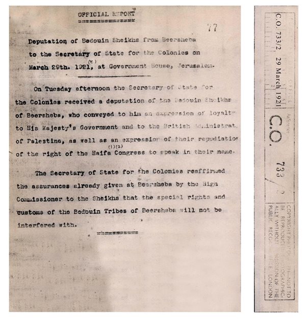 Fig-1.1: The decision of Winston Churchill, Secretary of State for the Colonies, to recognize the rights and customs of the Beer Sheba inhabitants, 1921 (Source: Palestine Land Society, London).
We provided passages from the reports of the Southern District Commissioner (district of Gaza-Beer Sheba) which were sent on a fortnightly basis to the High Commissioner from 1920 till 1948. Every report explains the essential items: rainfall (drought and abundance), the start of the farmers plowing their lands, quality of crops or lack thereof, the amount of taxes collected, assistance provided by the government in the form of wheat and feed (in the years of drought), tractors to plow the land, agricultural consultations for improving crops and combating pests such as worms. There were also reports on cases where courts would rule regarding disputes over land ownership. There was a report that mentions in particular Jewish fraud in regards to plowing land they do not own in Asluj in the district of Beer Sheba, according to the Land Transfer Law of 1940. When these Jews were summoned to attend, they presented a pledge not to transgress on this land, possibly due to fear of punishment, or maybe because they knew they would take this land for free in a war they were preparing for against an unarmed population.
Of course, no rational person can view the reports of the Southern District Commissioner referred to above–who was subordinate to the British government that was colluding with Zionism–as pointing out to “wilderness with no owner and not frequented from time to time with the exception of shepherds who came from Saudi Arabia and then returned”, as the Zionist expert Ruth Kark claims.
The matter is so clear that it is very strange–had it not been for the claims of Zionism–that we have to resort to proving it, just like proving that the sun rises from the east. Therefore, we sent to Nouri’s expert the map of the Land Transfer Law for the year 1940 [see Fig-1.2], which identifies 3 Zones: purely Arab lands where Jews are prohibited from ownership, the Jewish lands where Jews are permitted to own, and the transfer of lands in between the two provided a permission is obtained directly from the High Commissioner. So Zone A has an area of 16,680 square kilometres, and is purely Arab land where Jews are prohibited from ownership. It covers the area of Beer Sheba and other areas.
Although Israel seized all these lands after the Zionist invasion of 1948 and registered them as “State Land”, Britain however did not register Beer Sheba as state lands. If Beer Sheba was a barren wasteland, as Israel has claimed, Britain would have registered it as such. Accordingly, we presented a Mandate map to Nouri’s expert [Fig-1.3] which shows lands of the state (State Domain), and in the entire south there are no lands of the state except for sand dunes at the Khan Yunis coast and Rafah and a phosphate concession in the northeast corner of the Dead Sea.
Between the Zionist Orientalist concept and Palestinian reality ongoing since ancient time, there are paradoxes that are almost comical had their consequences not been so serious.
The Zionist expert presented a copy of the record from the Supreme Court of Jerusalem, which was record no. 59 of 1944 dated 20/5/1944. In this record, a sheikh from Al-Sane’ clan (which is from Al-Tiyaha tribe, namely the same tribe as Nouri Al-Uqbi) testifies that they are Arab nomads, and does so in a case filed by Fayez Darwish Al-Wahidi who is from the Al-Wahidat (Tarabin) Arabs and denies they are Arab nomads because they wear suits and fezzes and live in the city. The Zionist expert eagerly attempted to exploit this statement to prove that someone on the side of the plaintiff is testifying before the Mandate court that they were Arab nomads and therefore have no existence in those lands.
When we re-examined these papers which were sent to us by Nouri’s expert in order to clarify the matter, the truth became apparent, and it is one of many facts that Israel tries to obscure through deceit, forgery and lies.
The real story goes like this: near the end of the era of the Turkish government, the government resorted to calming the conditions between the tribes in relation to local wars, fights and disputes regarding land and livestock. It did so through reconciliations with them and presentation of gifts and certain articles of clothing, due to fears of British threats to its lands, which came to fruition by Allenby’s invasion of Palestine, along with the help of “Lawrence of Arabia” in East Jordan. When things settled down for Britain in both countries, the Turkish government continued with this process and set rules for “controlling the activity of tribes” which would take effect from Ma’an in Jordan to Beer Sheba in Palestine to Al-Arish in the Sinai. All of these locations were under British protection. These rules were implemented in the thirties of the last century. Accordingly, courts for the clans were held for reconciliation amongst them in East Jordan, the Sinai and Palestine. A law was issued for this purpose in 1942. Unfortunately for the Zionist expert, this law was called “Bedouin Control Law, 1942 (Nomad)”, in English, and so she thought that she could utilize this to prove her mythical claim by relying on the word “Nomad”.
-
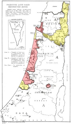 Fig-1.2: Map of the Land Transfer Law of 1940 prohibiting Jews from ownership of land in Zone A, which includes the Beer Sheba district (Source: Atlas of Palestine, 1917-1966, Palestine Land Society).
-
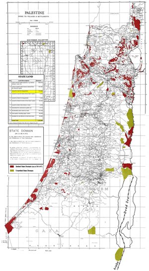 Fig-1.3: Map of the British Mandate “State Domain” of 1947 (Source: Atlas of Palestine, 1917-1966, Palestine Land Society).
What happened was that someone from Wahidat Al-Trabin killed somebody from another clan, and the killer resorted for refuge to the house of Abu Mu’ailiq where the women had gathered. So the sheikh judges issued a ruling that Al-Wahidat family leave the area to avoid the occurrence of another crime during what is known as a “temper flare-up” between people. Their departure was to continue until conciliation or some type of agreement could be reached between the two parties. The District Commissioner ratified this decision for the family’s departure. Here the killer’s family refused the decision and challenged the ruling before the Jerusalem Court. The issue presented was: Shall Al-Wahidat be subject to the Bedouin law that orders them to leave, or are they not Bedouins (i.e they wear fezzes)? The Jerusalem Court ruled that they are not Bedouins based on the testimony of the Al-Sane’ sheikh, who innocently testified that they indeed wear fezzes.
The whole affair, which is comical at times, is not related to land ownership nor cultivation nor the living of the inhabitants on the lands of Beer Sheba, but rather is related to a popular custom in what is known as the “cases of blood” which drive the killer to leave the region until conciliation takes place. The Zionist expert fell prey to her Orientalist ignorance regarding the meaning of ‘Nomad’ and what is really meant by it.
We sent Nouri’s expert this information, along with copies of the letters from the District Commissioner in which he explains this subject as mentioned above. We called the grandson of the plaintiff at the time at the Jerusalem Court in the Gaza Strip, and he affirmed the entire story. However Nouri’s expert unfortunately did not find the occasion to present this information. This was sufficient to expose the ignorance of this Zionist expert or rather her fabrication of facts. This is of course not surprising since the state expert immigrated, she or her parents, from Poland to claim the land of Palestine.
Yet Nouri’s expert–with his accurate research and constant perseverance in order to prove that Nouri Al-Uqbi has a right to his land as an Israeli citizen equal to the rights of Jewish Israelis–found a map of the lodging grounds of Palestinian tribes in the district of Beer Sheba [Fig-1.4]. They were so intensive that it cannot be rationally acceptable to state that this land is barren without any owner(s).
What is noticeable on this map is that the population density of the Beer Sheba district corresponds to the percentage of rainfalls, as these reach their peak in the north and west part of the district and then diminish elsewhere. This is logical and matches the reality on the ground.
At the end of the Mandate period, the Mandate Government presented a final report on Palestine to the Anglo-American Committee in 1947. The report stated that it had not been proven that the Beer Sheba district was necessarily mewat land as follows:
“It is frequently difficult to assume that there was in the past no grant, and consequently it is not safe to assume that all the empty lands south of Beersheba or east of Hebron, for instance, are mewat [page 77]... It is possible that there may be private claims to over 2000 square kilometers which are not cultivated from time to time. The remainder may be considered to be either mewat or empty miri [page 82]”.
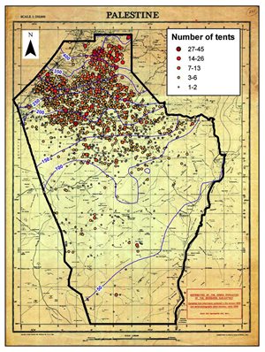 Fig-1.4: The lodging grounds of Arab tribes in the Beer Sheba district in 1947 (Source: N. Levin et al., Journal of Historical Geography, 2009).
The JNF Director had a field day in Beer Sheba court. Being the primary beneficiary of land confiscation, the JNF Director confirmed the land had no owner. He omitted to mention that, during the Mandate, the JNF failed to purchase land in Beer Sheba except for a tiny portion, less than 1% of the district. Obviously this purchase was made and the seller was a Palestinian who owned the land and now the remainder of his land is confiscated for free. The JNF has plans to give Jews large plots to build ranches of several thousand dunums, while its Palestinian owners are required to move to dormitory villages and work as cheap labour for European and North American settlers.
1.5 The Puzzle of Mewat Land
In its usurpation of the Beer Sheba lands, the government of Israel totally relied on these being “mewat” land and therefore becoming “State Land”. Israel did not mention that this land was usurped with armed force in 1948 and did not mention that it forcefully expelled its inhabitants and they became refugees, or that it expelled the remaining inhabitants three years later to a different region–even though they were now citizens–with the promise to return after a few weeks. It also did not mention that most of Al-Araqib lands and all of the land east of it including the town of Beer Sheba itself, are outside the borders of the presumed Jewish state and therefore lie within an Arab state according to the Partition Plan of 1947, and therefore are a part of the quarter of Palestine occupied by Israel over and above what the Partition Plan called for.
Israeli researchers, including Shamir and Kedar, have refuted the statement that Beer Sheba was mewat land and rebutted the definition of “mewat”, as per Article-103 of the Ottoman Lands Law, which was expanded by the courts of Israel to apply to the largest area possible in order to dismiss most lawsuits that the land was cultivated and with an owner. In the definition of Israeli courts, the following impossible criteria were listed:
- It is not permissible to use the condition of the extent of hearing a “loud cry” to determine the distance related to mewat land. This must be replaced with a modern scientific measure.
- The distance from habitation to mewat land must be more than 2.5 km.
- Distance shall be measured from a village or city (only).
- Distance shall not be measured from cultivated miri land.
- Measurement shall not take place from unfixed dwellings such as tents, even if they are inhabited and those persons cultivated their land.
- Measurement shall not take place from buildings or landmarks that are far apart, such as rural homes, buildings around a railway station, a police station or an isolated stone house, even if these places are inhabited.
- To prove that land is the property of a clan, the clan must prove that it was cultivating the land prior to 1858, the date of the issuance of the Ottoman Lands Law.
- To prove that the land is not mewat, it must be proven that the cultivated area represents more than 50% of the total land’s area.
- Certificates for payment of taxes on the land do not prove land ownership.
- A contract for the purchase by Jews of several lands from Arabs prior to 1948 and their acknowledgement at the time that the Arab owner had owned the land, does not mean he is the owner of the land that he sold a portion of. (This applies in a different manner to Al-Azazmeh tribe which sold land to the Turkish government to build the city of Beer Sheba upon, and also applies to the Beer Sheba municipality which granted 8.5 dunums of land to Britain to establish a cemetery for its soldiers in World War 1).
- Aerial photographic evidence taken by the British air force in 1945 may be accepted, with the following conditions:
- Cultivated land covers more than 50% of the land being requested.
- That the person claiming ownership of the land has cultivated it for 20 consecutive years. Since the photographs were taken by the air force in 1945, then this means that it must be proven that the land was cultivated till 1965 at least. However, the inhabitants were expelled from their homes in 1952, and therefore none of them can prove that they cultivated their land based on aerial photographs.
- The main requirement is that the burden of proof lies on the landowner him/herself, and not on the state. Since the state possesses all of the current documents which it stole from the Mandate Government and Palestinian institutions and inhabitants in 1948, and since the land owner has merely a few papers and extensive memory only, then the burden of proof on the land owner means his/her inability to convince the courts of Israel.
What is truly amazing is that, had it not been for the crime of ethnic cleansing of 1948–namely the expulsion of the indigenous population–then even if those lands had come under the rule of Israel, Israel’s entire argument that the Beer Sheba lands are mewat is without merit, based on the following simple facts.
The number of Beer Sheba’s population prior to the Nakba was 100,000 inhabitants distributed among 77 clans in 88 land locations. So the average number of people for every clan/village was 1,250. All serious estimates indicate that they cultivated an area of about 3,750,000 dunums, but no less than 2,500,000 dunums in the years of drought. In the first case, the area of the clan’s land is approximately 43 square kilometers with a radius of 3.6 km. In the second case, the area of the clan’s land is 28 square kilometers with a radius of less than 3 km, which is close to the maximum limit determined by Article-103 for specifying the distance of mewat land from habitation. Since the clans’ villages were in the north-western part of the district, which had heavy rainfalls, then by subtracting the valleys and hills from this area, the distances of habitation between one clan and the next are closer than the aforementioned criteria.
More significantly, if the inhabitants were not kicked out of their homes, the district’s population (in mid-2008) would have been 750,000, and so the distance between one clan/village and the next would have become 3 km (with a radius of only 1.5 km). This means that the villages and clans of Beer Sheba would be adjacent to one another starting from the habitation recognized in the Gaza villages to the south, east and west of Beer Sheba city. Therefore, their lands could never be “mewat”.
This of course is the goal behind displacing the Palestinians from their homes and claiming that their lands were wilderness with no owner.
It is worth noting that considering land as mewat is a major issue not only in the Beer Sheba district. Israel considers many regions in the Galilee area such as forestry, rugged terrain and mountainous areas to be mewat lands that it classifies as State Land. This matter also applies to the West Bank, where settlements are implanted and Israel declares that it has not expropriated anyone’s property. (Even according to the Israeli definition, the B’Tselem organization has finally proven that 40% of the lands that have settlements erected on them are owned by individuals.)
1.6 Role of the Law
There are two relevant fields of law, Israeli law and international law. As for Israeli law, there is a slim chance for the reacquisition of rights according to customary law (Murphy’s Law No. 3) which states: “According to the law of thieves, stolen goods cannot be recovered”.
Despite the great efforts by Nouri’s expert, he feels there is little hope that the Zionist court will rule for the return of the land to its owner. Despite this, the Adalah Center inside Palestine 1948 is doing a wonderful job in presenting claims and lawsuits to the Supreme Court of Israel, by providing a different interpretation of Israeli law. This means recognition of these laws, but interpreting them for the interest of the land owner.
With regard to international laws, they undoubtedly prohibit the seizure of lands in this fashion. David Kretzmer pointed out that UN resolutions, and in particular resolution A/RES/52/62 issued on 10/12/1997, mean that “Zionism has succeeded in extending its sovereignty over 78% of the area of Palestine but has not obtained the title deed of these lands”. This UN resolution stipulates:
It is requested that the Secretary-General take all appropriate steps, in consultation with the United Nations Conciliation Commission for Palestine, for the protection of Arab property, assets and property rights in Israel and to preserve and modernize the existing records... This resolution calls upon all the parties concerned to provide the Secretary-General with any pertinent information in their possession concerning Arab property, assets and property rights in Israel that would assist him in the implementation of the present resolution.
This resolution was not properly put into action. Similarly, the Advisory Opinion of the International Court of Justice issued in July 2004 on the apartheid wall, which includes some of the most significant material since the Balfour Declaration in support of the Palestinian cause.
Grassroots work is ongoing and plays a major role today, enabled by expedient means of communication such as the internet and satellite channels, which transfer information in real time in sight and sound. This is what happened in the process of destroying Al-Araqib village and the theft of its land.
In conclusion:
- Material support (firstly) and moral support must be provided to people in the region of Beer Sheba, so that they can hold steadfastly to their land, rebuild their homes, access means of livelihood, strengthen their capacity to defend themselves and mobilize the Palestinians’ forces within Palestine to stand with them.
- Human rights associations and associations for defending justice must be activated, and participation in their efforts must take place worldwide. This of course includes Palestinian, Arab and Islamic associations.
- Participation in the boycott, divestment and sanctions (BDS) campaign, which is growing in the West, must take place.
- There must be participation in all UN forums, whether the General Assembly or its various committees, to demand Arab rights in Palestine, in a realistic and direct manner.
- It would be very beneficial to send delegations of Beer Sheba inhabitants abroad, including men, women and children, to explain their case personally. This will have a profound impact on the West.
- Likewise, high-profile delegations can be received in Beer Sheba so they can see firsthand what people there suffer from. This can easily be arranged, since this visit can be added to the agenda of the Ramallah visitors, who are many, and those standing in solidarity with the Palestinians on the issue of the apartheid wall.
So the truth is clear and the work required is modest. Justice will ultimately prevail.
* Salman Abu Sitta is Founder and President of the Palestine Land Society, London. This article is taken from the current edition of Majallat ad Dirasat al Filistiniya (No. 85, Winter 2011). Translated to English by Rifat Audeh.