In wars, the victor frequently conquers a foreign territory, claims it as his own and produces maps to serve as the legitimate birth certificate of this territory. When these wars are motivated by ideology, especially that based on racism, the victor, not only claims the land, but empties it from its inhabitants. This is the war crime known as “Ethnic Cleansing”. The victor also obliterates the history of the vanquished by physically destroying his physical landscape and erasing its recognition by deleting its place names from maps, and replacing them with his own. It is as if the victim never existed. A new history and geography is then fabricated and marketed as the only truth. This happened frequently in ancient history but it never attained such planned efficient and advanced effort as it did in the 20th century. This is what happened in Palestine.
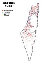
Luckily, now GIS comes to the rescue. The paper describes a careful and painstaking effort to collect the deleted history and geography by piecing together hundreds of documents from many parts of the world, primarily Great Britain. From these sources, the Palestinian land was reconstructed in “the Atlas of Palestine 1948” showing the description and location of 675 ethnically-cleansed villages and 99 remaining villages in the part of Palestine that was occupied in 1948 and called “Israel” today.
The Atlas also shows 11,000 land features (holy sites, water sources and administrative centres) and 25,000 place names which spells the alphabet of Palestinians’ long history in their land.
The Atlas also shows the successive Israeli occupation of Palestine in 1948, cases of war crimes and, the dispersion and the location of the refugees before and after their exile.
GIS techniques are not only used for a study of the past. They record the present as well and show the variances between the two, thus documenting the erasure and destruction of the vanquished Most importantly, it is an effective tool to study scenarios of the future and how rights can be restored. Thus the study not only records the violation of human rights but it also becomes the means to remove these violations and brings back justice and peace to this troubled region.
In the colonial age, mapping took a different turn from the old work of isolated geographical scholars. Mapping became a powerful tool of colonial domination. Maps were prepared, coloured by national colours and distributed among rival nations as a statement of claimed ownership and domination. The map was treated as the identity card of a territory and its birth certificate announcing that the father is a particular colonial power.
This domination certified by maps led sometimes to friction with rival colonial powers but more frequently with the indigenous population whose land was subject to foreign domination.
No where is history has this been the cause of so many wars, so much death and destruction, lasting for 90 years so far and still counting, than in Palestine.
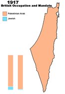
In 1917, James Balfour wrote a letter to the Jewish French billionaire, Lord Rothchild, promising to facilitate the establishment of a National Jewish Home in Palestine; a home not a state, in, not of, Palestine. That was the promise of those who do not own to those who have no title, in the absence of the rightful owners of the country. Neither Balfour, Rothchild or Weizmann, the head of the Zionist Commission to colonize Palestine, have ever set foot on the country, let alone lived in it.
Weizmann selected a fellow Zionist to help him. His choice was Herbert Samuel, the future British High Commissioner, entrusted by the League of Nations to restore the rights of Palestinians to achieve self-determination and self-government.
The opposite was planned. The Survey of Palestine department was hastily formed to map Palestine, not for topography, but to prepare Cadastral map and to verify the ownership of every single donum (1000 m2), the aim being to confiscate or transfer to Jewish immigrants, yet to come to Palestine, every possible piece of land, under the new laws created by Samuel, under the authority of the British Mandate government which came to build Palestine institutions for Palestinian self-government.
However this effort to transfer Palestinian land to Jews has not fully succeeded. During 30 years of British Mandate, the British settled land title for only 25% of Palestine, even though maps were produced at 1.20k scale for half the country and at 1:100k for three-quarters of the country.
During the Mandate the Jews succeeded in acquiring only 5.7% of the land but managed to bring in Jewish immigrants which increased their percentage of total population from 9% when the British came to 30% when the British left.
Although the British left us a fairly well documented country, they also left a bitter taste of betrayal in breaching the obligations entrusted to them by the League of Nations.
-
 Slide-1
-
 Slide-2A
-
 Slide-2B
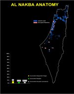
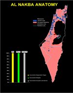
The Zionists, however, ready with their well-trained army, were preparing to bounce on Palestine. They did occupy by military force 78% of Palestine in 1948 and the remainder of 22%. That was al Nakba.
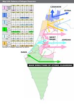
To illustrate this, [Slide-1] shows Palestine when Balfour issued his letter and Samuel assumed his duties. [Slide-2] shows animation of al Nakba. With animation, the Israeli conquest of Palestine becomes clear and graphic. It shows area of land occupied at each interval of 2 weeks; the number of depopulated villages and the number of refugees who have been expelled from their homes. Concurrently it shows the number and site of massacres which had been committed to put into effect the ethnic cleansing plan, the largest, longest and still continuous plan in modern history.
What is al Nakba?
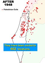
[Slide-3, 4, 5, 6, 7]: Before and after; direction of ethnic cleansing; exile locations; the aftermath; the dissection.
-
 Slide-3
-
 Slide-4
-
 Slide-5
-
 Slide-6
-
 Slide-07
Here is a total land occupied, two-thirds of its people became homeless, the other lived under Israel third under occupation.
To make matters worse, Ben Gurion, in the same week he signed the last Armistice Agreement, on 20 July 1949, assembled two dozen geographers, surveyors, Torah scholars and army officers and gave them the task of erasing all Palestinian names and replacing them with Hebrew sounding names.
In such planned, meticulous and persistent way, the land was taken, was expelled and their memory is erased. That is at least what they hoped. Here GIS could come to the rescue. But there were obstacles to overcome: first, to locate Palestine maps and documents. They were all confiscated by Israel. Second, to collect data and piece them together, to verify the names, to check boundaries, to compare against available maps, all this without the authority of a state to officially acquire documents or to get the technical and financial support of a big institution.
It was a big task, both in size and nature. Palestine history is very rich; there is no chance of taking it lightly.
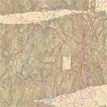
Here you have 1,300 towns and villages, the absolute majority were built by Palestinians over a period of several millennia. Their names are preserved in British Mandate maps (1920-1948) and in Palestine Exploration Fund Survey of 1871. The coastal plains was recorded by Jacotin in 1799. Many European travelers, priests, pilgrims, surveyors and spies charted the country by old methods.
The first Ottoman tax book, dafteri-mufassel, gave the names of villages, their population, their occupation and tax dues in 1596. The Bishop of Caesarea produced a gazette of Palestinian towns and villages, their location and distance of each other in the 4th century. So in principle, we have no problem there. Only work.
Then you have 11,000 religious, water and civic sites. Of high significance is the 5,000 religious or holy sites, which stood the test of time, conquest and changing of faith. They are in the same location for centuries, revered by the same people, even if they had different tongues or faiths. The majority is Muslim, less so, Christian, a minority are Jewish.
But to me the most important feature is place names. They are by far the largest, about 35,000.
These place names are the alphabet of Palestinian history. Through them, they recorded birth, marriages, deaths, happy events, such as victory over an enemy, sad events, such as death of a great man. They recorded social events, such as the marriage of a particularly beautiful girl or the peace prevailing between two warring families.
They recorded topographical terrain, the meadows, the hills, the mountains, the rivers and the wadis. They also recorded ownership, a field of this, a garden of that, a house of this or a manor of that. A whole history is crammed and spelled out in thousands of names. It is this what Ben Gurion and Zionists planned to erase. They failed. We now have the Atlas of Palestine.
Needless to say it took several years to collect the data: from Paris, Berlin, Munich and Istanbul. Of course the bulk is in about a dozen places in Britain. The UN library was useful, especially for wars and treaties. But the store house of all confiscated Palestine maps and documents in Israel was not accessible.
Digitization of maps was straight forward, but due to gaps in available data, and due to changes resulting from updating of maps, approximation and improvisation was needed. At all times, this approximation was confined to a small area. For example, village land area and location, as digitized, was very close to the official British Mandate records.
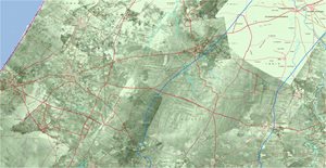
This work has been enhanced a great deal by the superimposition of several thousand aerial photos taken by RAF in 1945-1946 just before the British unceremonious departure.
These photos gave life to the landscape. This landscape showed that people cultivated their fields. It belied the slogan: Palestine is a land without people. It showed rich land: vegetation, gardens, fruits, particularly olives, almost every where that could be planted. It belied the slogan: we made the barren land bloom.
-
 Slide-8
-
 Slide-9
It showed towns and villages throbbing with life created by their people, these same people who became homeless after 1948. It also showed Zionist settlements, small and scattered but each built as a garrisons with soldiers ready to attack.
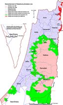
That was al Nakba of 1948. If we now turn to the occupation of the West bank and Gaza Strip in 1967, we have a case of the longest occupation in modern history.
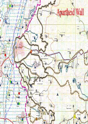
The paper map in your hand will show the details of these two catastrophic events in the Middle. But that is not enough. Let us see the case of the Apartheid Wall built on the West Bank land.
As you know, this Apartheid Wall was deemed illegal by international law according to the judgment of the highest court in the world, namely, the International Court of Justice in its verdict of 9th July 2004.
This demonstration is based on GIS mapping of the UN office of Humanitarian Affairs. Only GIS can demonstrate the devasting effect of the Apartheid Wall [3 slides]
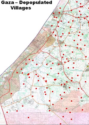
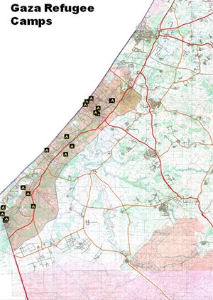
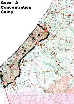
Then we have the case of Gaza the largest concentration camp of the world today. On and a half million people crammed in a tiny strip of 360 sq. km, deprived of food, power and medicine. Students are not allowed to go to universities, patients to hospitals, and workers to their jobs abroad.
But what is Gaza? Who is Gaza people? [3 Slides]
-
 Slide-10A
-
 Slide-10B
-
 Slide-10C
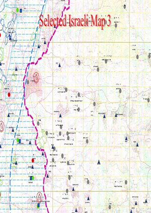
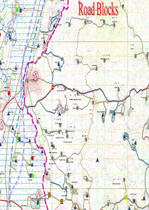
GIS also reveals hidden facts. Look at this map showing one part of Israel in Beer Sheba. You would think this is a true representation on the ground. No it is not. [3 slides]
-
 Slide-11A
-
 Slide-11B
-
 Slide-11C
GIS not only records facts, revealed or hidden, how tragic may be, but can also offer solutions. That is where we all should strive to do.
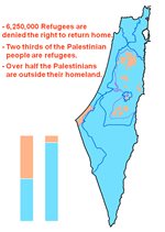
Take the example of 6 million Palestinians expelled from their homes in the part of Palestine now called Israel. Here is where they lived. Here is where they are now in exile.
The international law clearly affirms their right to return home. This supported by UN Resolution-194 repeated 130 times. Israel says they cannot allow them to return because their homes are already filled with immigrants. If that is so, is it justified? If not, what is the nature of the problem? Here again GIS comes to the rescue.
Take the case of the Northern District. [Slide-12]… and of the Southern District. [Slide-13]
-
 Slide-12
-
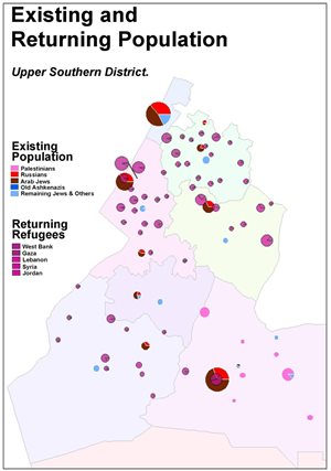 Slide-13
GIS can also determine the name of each refugee, where his original home is, where his location in exile is at present, what property he owns, what occupation, what family size.. and so on.
We can expand this analysis to include all other parameters, such as economics, education, health, water, transportation…etc. We can actually create a comprehensive plan for repatriation, similar to or better than that carried out in Bosnia, Kosovo, South Africa, Uganda, Guatemala, Abkhazia, Iraq and Afghanistan, for the repatriation of people expelled from their homes.
You would agree with me that GIS work for the solutin of problems is much more preferable than work done by tanks, rockets and fighter planes. The result of their work is death and destruction. GIS work aims at development, construction and growth.
That is how it should be. Because that leads to peace. And peace can only come through justice. Now you have the tools to serve justice.