In July 1949, Israel signed the last of Armistice Agreements with Syria. By then, Israel occupied 78% of Palestine, 50% over the partition plan, depopulating over 600 cities, villages and hamlets. Palestine became empty, making true the myth that “Palestine is a land without people”.
Ben Gurion was not satisfied. He wanted to erase every name or trace reminding the world of Palestine. In that same week, in July 1949, he gathered a committee of experts to erase all Palestine name and create Hebrew names.
The irony is that Israel continued to use the Survey of Palestine maps till 1962, marking Palestinian villages as “abandoned” or “heaps” or “debris”. Thereafter it produced Hebrew maps. There was a deliberate plan to create a bubble of denied in which Israel children were indoctrinated to deny that Palestine or Palestinians existed. In 1969, Moshe Dayan famously told Israeli student that kibbutzim were built on Palestinian village land. “You do not know this (he said) because geography books do not exist”.
If the geography books did not exist in Israel, they existed the world over.
 Link to iOS & Android app pages
I started a 20 year-long search in dozens of European, American and UN libraries to gather maps and documents from which the Atlas of Palestine was created.
A remarkable result was obtained. After recording 50,000 names, it occurred to me that this is the vocabulary of the Palestinians’ social history. They carved it over hundreds of years without a committee of experts. They do not need Kushan or Tabu to prove their presence because they gave every dunam 3 or 4 names.
In all we recorded:
- 1,500 names of human settlements, i.e. towns, villages, hamlets and tribal lands.
- 16,000 names of religious or historical sites, such mosque, churches, synagogues, maqams, shrines, cemeteries, wells, springs and other land features
- 30,000 place names covering almost every dunam in Palestine.
Village names in Palestine often refer to the families which inhabit them. there are 120 names with prefix name: Bayt, that is the house of such and such, Bayt Lehem, Bayt Itab. There are 51 names which start with Kafr meaning the village of a particular clan. There are 2,500 localities with name Khirbet, that is hamlet or a ruin of an older place, which was or still in inhabited, but recognized all along. This alone shows the deep rooted history of Palestine.
However the life of the Palestinians is recorded not only in the names of these localities and their religious sites but also in a new category of names which had been rarely studied ever, or even recorded in one volume, except the Atlas of Palestine.
These names honour family; they refer to Abu, Umm, Ibn, Bint, as prefix almost 3,000 times. These names indicate features such as Umm esh Shuqaf. They indicate ownership; Ali garden, Hussein field. They indicate planted fields; olives, grapes, figs. They indicate places where animals are common, horses, camels, gazelles, wolves, foxes. Or birds; hamam (pigeons), falcons. They indicate colours of the land; red, yellow, or terrain; tell, cliff, meadow. They indicate wells, springs and ponds. They indicate trades, such as pottery factory, grapes press, wind or water mill. They indicate the relative location of nearby village; upper, lower, in-between, (tahta, fauqa, bein). They indicate special events; the horses’ birthplace, the killing site of the chief, the hanging site, the battle scene. They indicate strange names such as; going up and down, the good name, good morning, the morning star, shield protector, wolf’s face, dog’s tale.
All these 30,000 places have names of people, created by people, for people’s recognition and use. It was their life etched in their use and speech. That is what Ben Gurion wanted to destroy. He would have turned in his grave if he knew that all such heritage that he erased was restored. What did he want to replace it with?
The official Israeli Gazette produced, after arduous work, only 6,800 names, almost one tenth of Palestinian names. These were names of Israeli settlements in Hebraic fashion and names of prominent Zionist leaders given to mountains and streets. The Israeli names are short of Palestinian names by 33,000 names.
Then in 2006 we produced the Return Journey which shows Palestinian maps with new Israeli’s road map superimposed on them.
So you could reach your village of origin on today’s road nature.
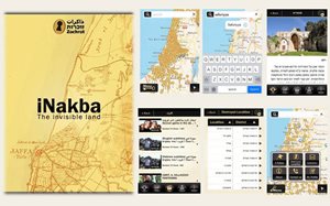
Hence the iNakba application is a tremendous achievement. You do not need to be a scholar to read maps. You do not need to acquire atlases which are not easy to find.You have it all on iPhone, just look, identity and drive.
Congratulations to Zochrot team in their continuous effort to pierce the bubble of denial. They are doing the Israelis’ good service. The whole world, and increasingly in the west, as I have seen just returning from a tour in USA and Europe, know more and more facts about Palestine. The Israelis are the only people who are left in the dark.
But we should not stop there. We must start implementing the Return. We did an advanced study about the demography of Return.
We found that 250 Palestinian village lands have no Jews today and another 250 village lands have very few Jews, from 100 to 1,000 or 2,000 in each locality.
The Jews still live in cities in 3 metropolis: Tel-Aviva-Yaffa, Jerusalem and Haifa-Acre.
We took another forward step. We have a project in progress to documents every destroyed Palestinian village completely.
The result will be put to an international competition among Palestinian architects to re-design and build their villages on the same location but for a 21st century quality of life.
Fifty percent of refugees can actually walk back to their homes and another 45% need a bus ride. They do not need ships or planes. They are looking at their homes across the barbed wire. They are waiting and ready to return.
And they will return, because that is the only condition for permanent peace.