Source: Badil
The Beer Sheba (Bir Saba') district is the least understood and most mispresented part of Palestine in terms of the number of refugees and related land and property claims. In 1948, the entire district was occupied by Zionist/Israeli forces. Today the district comprises 62 percent of the area of Israel. In the southern half where rainfall is less than 100 mm/year sustained agriculture is minimal. Apart from grazing, this southern half is rich in minerals and archeological sites dating back to the 4th century AD Ninety-five percent of the indigenous Arab population used to live in the fertile north where land cultivation was extensive. Today, the total population of Beer Sheba district is about 700,000.
Documentation, which dates back to the time of Napoleon dispells the myth that the land was barren and had no owners. In 1799 Napoleon ventured into the Arab East with dreams of establishing an Eastern Empire. Napoleon's campaign marked the first European invasion of Arab lands since the Crusades of the 12th century. While the military campaign ended in failure, Napoleon's expedition left behind a rich scientific legacy. The encyclopedic La Description de l'Egypte, compiled by Napoleon's seventy-nine savants, for example, includes a detailed description of Arab clans all the way from Cairo to Damascus.
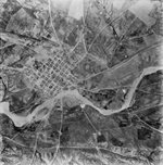 1945 aerial photo of Beer Sheba (courtesy of Salman Abu Sitta).
When Napoleon crossed the Sinai and advanced into Palestine in February 1801, he and his troops were amazed to encounter the wintery climate and the green landscape of Palestine. To his haggard soldiers, the landscape of Palestine was a welcome respite–in appearance much "like France". As they marched north through Palestine, Napoleon's savants and 'Syrian' dragomen documented the size of the Arab clans in the south, a description of their homelands, and the number of their cavalry (fursan [faris, singular]). This is probably the first modern European record of the inhabitants of Bilad Ghazzeh (Beer Sheba and Gaza), Gaza city being the capital of the southern half of Palestine.
European travellers, priests, spies, soldiers and 'Syrian' and Egyptian historians also wrote extensively about life in Palestine during the 18th century. At the time, the area was under the control of the Ottoman Empire. The authority of the Ottoman-appointed governors (mutassarref), aided by a small armed garrison, however, was limited to the main cities of Palestine. Palestine was thus effectively ruled by its people. This was no more true than in the southern half of Palestine known as Beer Sheba. Arab clans largely governed their own territory, administered their own affairs, and even had their own 'armies'.
While the clans of Beer Sheba were never conscripted by the Ottoman regime, they would often acquiese to the Sultan's wishes, if so pursuaded, to put forward an independent 'regiment' during times of war. In 1914-1915, for example, Beer Sheba clans sent 1,500 cavalry to fight the British at the Suez Canal. The clans also fought against each other. Almost always the source of conflict revolved around territorial disputes. Within the tribal homeland, everyone knew the limits of his own property. As was customary in Palestine, boundaries were well marked by a wadi, road, distinctive trees or a cairn. Trespassing on another clan's property was regarded as a valid reason for a 'war' which could last for 20 years.
All suitable lands in Bilad Ghazzeh were cultivated, dependent on the rainfall in any given year. North and north west of the town of Beer Sheba, rainfall exceeded 300 mm/year and was suitable for growing winter wheat and maize and water melon in summer. Wheat crops extended from the city of Majdal in the north all the way to Wadi Ghazzeh in the south. Rev. W. M. Thompson, who visited the area in April 1856, described the horizon in his famous book, The Land and the Book, as "wheat, wheat, an ocean of wheat". According to the head of the British Geological Mission to Palestine in 1883, Edward Hull, "The extent of the ground here [near Beer Sheba] cultivated, as well as on the way to Gaza, is immense and the crops of wheat, barley and maize vastly exceed the requirements of the population". To Hull, the area looked like southern Italy. Just before the First World War, the Gaza port was crowded with vessels carrying wheat for export. Beer Sheba was truly the bread basket of Palestine.
In 1863, Victor Guerin, the French scholar who wrote volumes and drew maps of all Palestine, recorded the land ownership of each clan. It was not until the late 19th and early 20th centuries, however, when serious scholars began mapping and recording the territory in great detail. Some of these scholars were also professional spies, working on behalf of European states each vying for a piece of the Ottoman cake. Anxiously waiting for the demise of the 'sick man' of Europe they began staking out territorial claims to parts of the vast Ottoman Empire. Records of these scholars/spies include the voluminous work of the Austrian-Czech scholar Alois Musil. Musil, who was working unofficially on behalf of the Hapsburg Empire, documented the names, numbers and the lands for all clans, including those in Sinai, Syria and Hejaz. Not to be outdone, the Germans sent their spy, a.k.a. scholar, Baron Max von Oppenheim. Father Jaussen of l'Ecole Biblique in Jerusalem worked on behalf of the French.
Ironically, it was the latecomers who eventually took control of Palestine. The British, who were stationed in Egypt since 1882, began surveying the 'Negev' (a word foreign to the Arabs, meaning south) rather late. Stewart Francis Newcombe, a British officer and surveyor who rose to prominence as the person responsible for the delineation of the boundary between Palestine, Syria and Lebanon, produced an excellent map of the 'Negev' in 1914. This map was the main source of information for General Allenby, Commander-in-Chief of the British Expeditionary Forces, during his campaign in Palestine in 1917.
The famous Lawrence of Arabia, made a fleeting visit to Beer Sheba in 1914 disguised as–what else–an archeologist, and wrote a report on it, under the title of Wilderness of Zin. In addition, the Palestine Exploration Fund began work in Palestine in 1871. The survey took 8 years to complete, 4 years in the field and 4 years of writing in London and included 26 maps and 10 volumes covering the area. However, it only covered one third of Beer Sheba district, ending at Wadi Ghazzeh in the south.
The Mandate Period
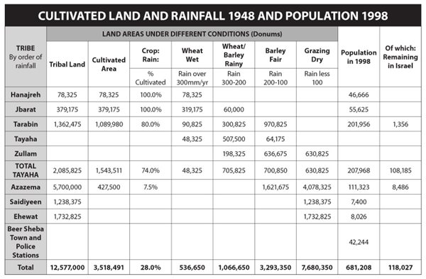
Beer Sheba District was the largest district of Palestine during the period of the British Mandate, comprising 12,577,000 dunums (4 dunums=1 acre) out of a total area of some 26.3 million dunums. According to British Mandate government records there were 77 official Arab clans (ashiras) grouped into 7 major tribes in the district, in addition to Beer Sheba town and about a dozen police stations. (See Table below)
Land ownership in the Beer Sheba district was always held on the basis of tribal custom–i.e., customary law. On the basis of established tribal customs individual plots were sold, inherited, mortgaged, rented, divided or taxes paid. Official records identifying general land ownership of each clan were first prepared in relation to the establishment of a border between Egypt and Palestine known as 'the administrative line of separation.' Official correspondence between Captain R.R. Owen and W.E. Jennings Bramly, Sinai Inspector, between 1895-1906, which culminated in the Palestine-Egypt Agreement (1 October 1906), refer to the Arab clans and their tribal homelands. W.C. Churchill, British Colonial Secretary, and Herbert Samuel, the first High Commissioner of Palestine, also recognized the customary property rights of Arab clans in the Beer Sheba district.
Article-45 of the Palestine Order in Council confirmed that legal jurisdiction in the Beer Sheba district would be governed by tribal custom. The British Mandate government waived the Land Registry fees in Beer Sheba to facilitate acquisition of title deeds. Arab clans, however did not take up the offer as they saw no need for confirming land ownership on paper. They responded with what became a classic answer, "With this (pointing to their swords), we register".
In 1920, the pro-Jewish British Mandate government created a Land Settlement Commission in order to examine the status and ownership of land and facilitate the settlement of Jewish immigrants in Palestine. Members of the Commission included an Arab (Faidi Alami), a Jew (Haim Kalvarisky) and the Chairman was British (Albert Abramson). Kalvarisky was also the manager of the Palestine Jewish Colonization Association (PICA) established to acquire land for Jewish settlement. Kalvarisky therefore had a vested interest in minimizing the estimate of cultivated land in Palestine.
The Commission's Report for 1921, essentially written by Kalvarisky, estimated the amount of cultivated land in the Beer Sheba district at 2,829,880 dunums. It also listed 1,059,000 dunums as grazing land. The estimate was based on agricultural production and tax receipts. Commission estimates, however, used double the commonly accepted yield/dunum value, hence the real area should have been double that calculated. Further, estimates of the total area under cultivation were based on the assumption that the land was cultivated one year and left fallow the following year. While this may have been acceptable for moderate rainfall, it is not so for light rainfall as in Beer Sheba where land may lie fallow for between 1 and 3 years. The maximum cultivated area in the Beer Sheba district at the time should therefore have been estimated at least double that listed in the Commission's report or about 5,500,000 dunums.
Other estimates for cultivated areas, based on rainfall figures, gave a minimum of 3,750,000 dunums and a maximum of 5,500,000 dunums plus about 750,000 dunums for grazing. Still, this is considerably less than the total area which receives rainfall from above 300 to 100 mm/year. Areas by maximum rainfall are by measurement: above 300 mm/year (1,042,250 dunums); 300-200 mm/year (2,080,000 dunums); and 100-200 mm/ year (5,784,000 dunums). The total area of rainfall in the Beer Sheba district thus amounted to 8,900,000 dunums. Aerial surveys of the heavily populated northern half of the district taken by the British Royal Air Force between 1945 and 1946 show intensive and close cultivation. It is thus evident that the regularly cultivated land in the Beer Sheba district owned by Arab clans was not less than 5,500,000 dunums of which 3,750,000 dunums was cultivated annually. Total land utilized for cultivation at one time or another for grazing was around 8,900,000 dunums. So much for the Zionist myth that the land in southern Palestine was not cultivated.
Under the 1940 Land Transfer Regulations, the British mandate government divided Palestine into three zones in order to regulate the transfer of land between Arabs and Jews. The measure was put in place as an attempt to stem the growing number of landless Palestinian Arabs and their decline in living standards. The Beer Sheba district was included in 'Zone A' (comprising 16,860,000 dunums in total) where transfer of land save to a Palestinian was prohibited except in certain circumstances. Much of the land claimed by Jews in Beer Sheba was not legally registered. Total land registered in Jewish possession on the eve of the UN recommendation to partition Palestine in 1947 did not exceed 60,000 dunums or 0.5 percent of the Beer Sheba district.
The fortnightly reports of the District Commissioners to the High Commissioner in Jerusalem, forwarded to London, are replete with examples of Jewish fraud and illegal land dealings, particularly in the 1940s. The following excerpt from the Gaza Fortnightly Report No. 161, of 1-15 October 1945 from District Commissioner (Gaza) to Chief Secretary, Jerusalem, is one example:
Protests have been raised at attempted ploughing by Jews of land in Asluj to which they have an extremely doubtful title. I am hearing a case under the Land Dispute (Possession) Ordinance, pending a decision by the Land Court. There are large areas in Beer Sheba sub-district which the Jews claim to have bought before the date of the Land Transfer Regulations but which are not registered in the Land Registry.
In order not to be exposed, the Jewish defendants submitted an undertaking to the District Commissioner not to plough the land in question otherwise the Court would have clearly ruled against them. The land was never registered in the British Mandate Land Registry, yet it appears as 'Jewish' in maps prepared by Yosef Weitz, Director of the Jewish National Fund Land Department/Development Division.
Al-Nakba
Jewish presence in the Beer Sheba district expanded exponentially as a result of Zionist/Israeli military occupation during the conflict and war of 1948. The district was nearly completely cleansed of its indigenous Arab population. From October to December 1948, Zionist/Israeli forces expelled almost all the population to the Gaza Strip, al-Khalil (Hebron), and Jordan. A smaller number ended up in the Sinai.
Many of the Jubarat tribe were expelled in early July 1948. The complete expulsion of the tribe, however, took place after Operation Yoav which started in mid-October 1948. A small group went westwards to Gaza and eastwards to Hebron in the West Bank, but the absolute majority ended up in Jordan especially after 1967. The Terabin remained in their homes until November/ December 1948. They were expelled towards Gaza in the Israeli attack against Egypt that came close to al-Arish in the Sinai. Today the majority are refugees in Gaza with a considerable number in Jordan. About 1,000 remain in Israel.
The Tayaha tribe, including Dhullam, were split during the war. Almost half were expelled to Gaza and Jordan and half remained in Israel. They represent about 90 percent of those Palestinians who remained in Beer Sheba. Remnants of other tribes make up the remaining 10 percent. The al-Hanajera, whose land straddles the railway line, leaving half of their land in Gaza and the other half in Beer Sheba, were displaced to Gaza Strip after the main Israeli attack on Gaza at the end of December 1948. The al-Azazema had a mixed fortune. Their land extends from Palestine south into the Sinai (Egypt). They were expelled to the Sinai during the war. Some, however, returned, but were expelled again between 1950 and 1954. Ariel Sharon, then commander of the infamous unit 101, massacred many members of al-Azazema during land and air attacks. Some fled to Egypt but eventually returned.
Smaller tribes in the southern part of the district were expelled to Jordan through Wadi Arabeh. The files of the Arab Legion, then commanded by Glubb Pasha, are filled with reports of their expulsion and mistreatment by Israeli forces.
After 1948
Approximately 12 percent of the population of the Beer Sheba district remained within the territory that became the state of Israel in 1948. As elsewhere the remaining Palestinian Arab population was placed under military administration. Moreover, Israel transferred the remaining inhabitants of the district into a reserve (siyag) north and north-east of the town of Beer Sheba. The area of the siyag comprised a mere 900,000 dunums or about 7 percent of the total area of the district. The cultivated area of the reserve was about 360,000 dunums. Out of the total area of the district (12,577,000 dunums), Israel 'leases' 250,000 dunums annually to Palestinians for cultivation in addition to recognizing ownership rights to only 150,000 dunums. The 'lease' can be revoked any year, rendering cultivation a risky business. Granting the 'lease' is subject to coercion and frequently conditional on providing 'services' to the state.
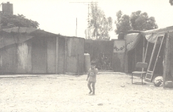 Unrecognized Bedouin village in the Naqab. Photo: Regional Council for Palestinian Bedouin Unrecognized Villages (RCUV).
As in other areas that became part of the new Jewish state, the Israeli government adopted pseudo-legal measures to confiscate and acquire control of land in the Beer Sheba district. Israel maintains that Beer Sheba District is 'state land' on the basis it is "Mewat" land, according to the Ottoman Land Law of 1858. Article-103 of the 1858 Ottoman Land Law specifies Mewat land as (1) vacant; (2) grazing land not possessed by any body; (3) not assigned ab antiquo to the use of inhabitants; and, (4) land where no human voice can be heard from the edge of habitation, a distance estimated to be 1.5 miles (2.85 km). The latter is a distance travelled on a horse in about 40 minutes, such as in wilderness where no human being lives ordinarily.
Israeli authorities thus claimed that tribal lands in the district had no owners while the remaining inhabitants of the district were simply 'nomads.' This claim is entirely false. It is clearly evident that such description does not fit in any way the populated and cultivated areas mentioned above. Indeed any casual observation of the district at the time would confirm this. There is a great deal of historical evidence, including British Mandate documents, maps and aerial surveys. Israel's claim that land held in customary ownership by Arab clans in the Beer Sheba district is Mewat, hence state land, cannot constitute a serious legal claim. If the term Mewat applies at all, it may apply to the southern tip of the district, but certainly not to where 95 percent of the population live.
Israel also reactivated the 1921 Mawat Land Ordinance which prohibits cultivation of Mewat land, unless the cultivator obtained legal acquisition by registering the land within two months of the promulgation of the law. Israeli officials claimed that since the Palestinian Arab cultivators/owners did not register their land in 1921, they are not entitled to ownership rights. Israel refused to consider Ottoman and British tax records (tithe) and other evidence, when available, as proof of ownership. The state, however, recognized Palestinian ownership rights if the same land was sold to Jews before 1948. Israel also initiated a settlement of title plan by which the state agreed to recognize Palestinian ownership if the owner agreed to forfeit 50 percent of his property to the state, 30 percent be compensated for a pittance and with the owner allowed to keep the remaining 20 percent. There were few takers.
Israel considers itself a successor state to the former Mandatory Palestine. If this assumption refers to its military conquest outside the limits of the partition plan, the inadmissibility of the acquisition of territory by force and the Fourth Geneva Convention safeguard the property of the subjugated people. International law stipulates that, upon extending a new sovereignty on a territory, people and land go together. Expelling people and confiscating their land is not permissible. On the other hand, if this assumption refers to the UN Partition Plan (Resolution-181), which was the basis of Israel's declaration of independence in 1948, this resolution clearly stipulates that Arabs in the Jewish state (and vice versa) shall enjoy full civil and political rights, including ownership, without discrimination on any grounds.
When military rule was lifted in 1966 and it was possible for the remaining Arab clans to leave the siyag, many owners submitted applications to repossess their land. In 1969, however, the state adopted a new law declaring "all Mewat land as state land". Moreover, the law stipulated that long-time possession does not confer ownership rights. Until 1979, 3,220 applications were filed–none was recognized. Still, confiscation continued. Land was expropriated under the 1953 Land Acquisition (Validation and Compensation) Law and the 1980 Negev Land Acquisition (Peace Treaty with Egypt) Law. It is curious that the Peace Treaty with Egypt should be the excuse for land confiscation. Restoration of land to owners would be more in the spirit of peace.
Update on Bedouin in the Naqab
Over the past three months the Israeli government has continued its assault on the indigenous Bedouin population of the Naqab. On 2 April the Israel Lands Administration once again sprayed toxic chemicals on crops planted by local Bedouin. Villages affected included Umm Batin, east of Omer; al-Mekiman, south of Laqiyya; A'ojan, west of Laqiyya; A'araqeeb, south of Rahat; and Sa'wa and Umm Heran, both east of Hura. A total of 2,000 dunums of crop land was destroyed.
At the same time, the government set aside new money in the "Emergency Economic Plan" to fund a plan to remove the remaining Bedouin living in unrecognized villages from their land and extinguish all outstanding land claims. Some 56 million NIS are budgeted for the implementation of a transfer program under a new amendment entitled "The Eviction of Trespassers". The amendment will give Israeli officials the power to classify anyone living on state lands as a trespasser without going through lengthy court procedures. Under the amendment it is not possible to argue that the villages have existed since before the creation of the state of israel, or in other cases that villagers are living on land that were transfared to by the state following the confiscation of their original lands.
The program will create a military and judicial system to expedite the transfer of 70,000 Bedouins from 'unrecognized villages' into the 7 'legal' settlements. According to the Mossawa Center, some 12.5 million NIS will go to the Green Patrol (an environmental paramilitary group), 15.5 million NIS for the creation of a new police unit, and part of the remaining 27 million to the Israel Lands Administration to be used for the purchase of airplanes most likely to monitor Bedouin development and agriculture.
Mossawa Center, 4 April 2003; and, Jonathon Cook, Bedouin in the Negev Face New 'Transfer', MERIP, 10 May 2003.
Israel also established 7 planned townships (Rahat, Tel Sheva, Kessifa, Ar'ara, Shegib, Hura, Laqiya) in order to resettle or rather 'sedentarize' the Bedouin population and uproot them from their traditional life. The combined area of the townships is a mere 57,778 dunums. Approximately 50 percent (about 130,000) of the Palestinian population of the district lives in these socalled "recognized villages". The remaining 50 percent have refused to be uprooted and remain in 46 "unrecognized villages". These villages are not shown on Israel's maps. They are not connected to roads or provided electricity, water, health and education services. Because of distances, residents must travel miles for these services. They receive no subsidies or economic support.
In 1976, the the government established a so-called "Green Patrol" to prevent, in the government's words, "Arab encroachment on state land". Dubbed as the "Black Patrol", the government funded patrol regularly demolishes Palestinian Bedouin homes and tents, ploughs over crops, uproots fruit and olive trees, sprays crops with toxic chemicals, demolishes dams, shoots dogs and flocks, and evicts people from their traditional lands. Despite overwhelming evidence of brutality, charges against Green Patrol are not upheld in court.
The purpose of all these measures is to confiscate land and gather the Palestinian population of the former Beer Sheba district in residential centres (reserves) to provide cheap labour for Jewish industries. Uprooting them from their land and depriving them from their livelihood (mostly agriculture) is meant to achieve this purpose.
Early in 2003 the Sharon government initiated a five-year plan, with a budget of US$100 million to Judaize the Beer Sheba district. This includes a plan to establish 14 new Jewish colonies, increase the power of the Green Patrol, and erase the 46 unrecognized villages. The first colony to be built is slated to be built on the land of Araqeeb village, the site of a massacre of Palestinians by Zionist/ Israeli forces in 1948.
Attacks on Camps
Attacks on refugee camps and refugee-populated areas violate international humanitarian, human rights, and refugee law. In order to continue to bring attention to the ongoing Israeli attacks on Palestinian refugee camps in the 1967 occupied territories and the urgent need for international protection, BADIL has prepared this short summary of attacks on refugee camps and refugee populated areas. The table covers the period 1 April-1 June 2003. The information is based on reported cases.
- 2 April, Tulkarem RC.
- 4 April, Nuseirat RC and Jenin RC.
- 6 April, Rafah RC (Block J), 1 wounded.
- 10 April, Rafah RC (Block L), 1 injured.
- 15 April, Balata RC.
- 16 April, Rafah RC (Block O), 1 injured.
- 17 April, Jenin RC, 1 child injured.
- 17 April, Rafah RC (Block O), 3 children injured.
- 19 April, Rafah RC, 5 houses destroyed, 20 damaged. 5 killed, including 2 children and 30 wounded.
- 28 April, Jenin RC, 1 child killed, 2 injured.
- 1 May, Rafah RC (Block J), 1 injured.
- 2 May, Qalandiya RC, 5 injured.
- 4 May, Khan Younis RC, 3 injured.
- 4 May, Balata RC, 1 child killed, 7 injured.
- 5 May, Khan Younis RC, 1 child injured, some houses damaged 5 May, Khan Younis RC. 3 houses damaged.
- 6 May, Tulkarem RC, 2 injured.
- 11 May, Khan Younis RC, 3 homes destroyed. 1 injured.
- 12 May, Khan Younis RC, 26 homes destroyed, 30 damaged. 20 injured including 6 children.
- 14 May, Jenin RC, 6 children and 1 woman injured, 1 child later died.
- 17 May, Rafah RC (Block J), 6 houses demolished, 3 injured.
- 18 May, Khan Younis RC, 1 killed.
- 18 May, Rafah RC (Block J), 10 houses demolished, others damaged.
- 21 May, Rafah RC (Block J), 10 houses demolished.
- 29 May, Jenin RC, 1 killed.
- 29 May, Rafah RC (Block J), 8 houses demolished.
Sources: Palestine Human Rights Information Center (Gaza). For more information see, 'Physical Protection for Refugee Populated Areas', BADIL Occasional Bulletin No. 6 (May 2001) available on the BADIL website, click here
Salman Abu Sitta is founder and president of the Palestine Land Society.