-
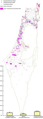 Fig-1: From Partition Plan to Plan Dalet (April 1948) The Zionists expanded their land holdings under the Mandatory Government of Palestine from 6% of Palestine by expelling the population of 30 Palestinian villages.
-
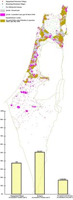 Fig-2: From Zionist invasion (Plan Dalet) till end of Mandate: Two hundred towns and villages were occupied and over half of the refugees were expelled without intervention by the British Mandate Government. Israel was proclaimed on 11% of Palestine.
The Palestinians' dispossession and wholesale ethnic cleansing of the population is unparalleled in modern history. It is called al Nakba, a Palestinian holocaust.
The gravity of this catastrophe is amplified by the fact that it was not a single act of war (as the case for Nazi atrocities). It is in fact a premeditated, carefully executed and continuous process still being carried out to this day, 53 years after the first onslaught in 1948. Reading the newspapers today or watching the TV news is a grim reminder of the same dispossession and expulsion of 1948, albeit on a different scale, style and location.
It is therefore important to understand how the original Nakba took place. This is best illustrated in a series of maps.
The period from the passing of the Partition Plan (UN Resolution-181) on 29 November 1947 to the onset of the Zionist invasion (Plan Dalet) around the end of March 1948 [Fig-1]:
The land under Jewish possession did not exceed 6% of Palestine. The Zionist forces started occupying nearby Arab villages to provide continuity and expand Jewish-held territory. The population of 30 villages were expelled. Naturally, all such territorial expansion, initiated by the Jews only, took place at the expense of Arab land.
From the Zionist invasion according to Plan Dalet, in early April, to the end of the British Mandate and creation of the State of Israel on 14 May 1948 [Fig-2]:
Under the watchful eye of the British Mandate government, the Zionist forces initiated an organized operation for the conquest of Palestine, starting with linking up scattered Jewish colonies along the coastal strip, along Marj Ibn Amer Plain, up along the river Jordan north of Tiberias, in the form of a large N. Two hundred towns and villages were occupied and their population expelled in this period. This included key Palestinian towns: Jaffa, Haifa, Tiberias, Safad, West Jerusalem (partly). Acre was occupied a little later.
Already over 50% of the refugees were expelled before a single Arab regular soldier came to their rescue. The British Government, whose Mandate was to protect the civilians, failed to do so. The British High Commissioner, whose office was a mere 5 km away from Deir Yassin, refused to interfere in the ongoing massacre there.
The State of Israel was declared on 14 May 1948, without any specific borders, on a captured territory of Palestine, not exceeding 11%. All subsequent expansion (now 100%) is considered illegal for those countries who gave de facto recognition of Israel at the time.
-
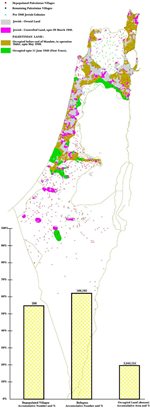 Fig-3: Palestine War up to the first truce:Arab regular forces entered Palestine on 15 May 1948 to rescue what is left of it. They were outnumbered by the Zionists/Israelis.They did not have joint command or coordination. The refugees' number swelled to 500,000.
-
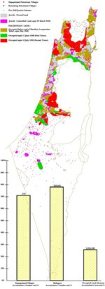 Fig-4: Palestine War up to the second truce: The Israelis broke into central Palestine,to Galilee and towards Jerusalem, depopulating 378 towns and villages. The inhabitants of Lydda and Ramle (70,000) were forced to march in July heat to exile, on the orders of Yitzak Rabin. Many died on the "death trek".
Palestine War: From 15 May to First Truce on 11 June 1948 [Fig-3]
Contrary to Israeli myths, Zionist soldiers greatly outnumbered the Arab regular forces at this period. Various Arab regular forces entered Palestine without proper coordination or joint command. This greatly accentuated the Israeli superior numbers. The Arab forces failed to recapture occupied villages and lost a further 90 villages. The refugees’ number swelled to about 500,000. The first truce was declared.
Palestine War: From 12 June-18 July 1948 [Fig-4]
The Zionist forces (now called Israeli) felt emboldened as they received more WWII veterans and war materiel in the first truce. They outnumbered the Arabs in number and weaponry. They broke the truce on 8 July and occupied two main central towns: Lydda and Ramle and expelled their population (70,000) on the express orders of Yitzak Rabin. They also occupied a corridor to Jerusalem, parts of Galilee, including the historical Nazareth city, and a pocket south of Haifa which remained Palestinian till then.
Now Israelis were assured that their position was secure. The next task was to solidify gains and expand to conquer as much land as possible.
The number of refugees jumped to 630,000 (80% of the total). They were expelled from 378 towns and villages. By this time Israel occupied 3 times more Arab land than it had under its possession in the Mandate period. This land was the most fertile and the most heavily populated part of Palestine.
This explodes the Israeli myth that little David is fighting for his existence against the onslaught of the giant Arab Goliath. The falsehood of this claim was already known to the British and American diplomats as early as January 1948.
-
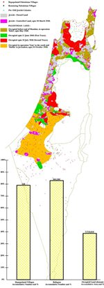 Fig-5: Palestine War up to 24th October 1948: The Israelis turned south and attacked the Egyptian positions. In one swoop they occupied 7,700 sq. km.
-
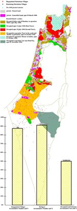 Fig-6: Palestine War up to 5th November 1948: In the following two weeks, Israelis turned north to Galilee where they committed 25 massacres and expelled the inhabitants of 443 towns and villages to this date.
Palestine War: From 19 July-24 October 1948 [Fig-5]
After a long truce, Ben Gurion planned for the occupation of the dominantly Arab Galilee, not allocated to Jews in the Partition Plan, and the absolutely Arab South. The Israelis attacked the Egyptians in the south, around Iraq Sweidan, on 15 October and occupied 7,700 sq. km. in one swoop without interference from other Arab forces elsewhere. General Abdel Nasser, later the celebrated national leader of Egypt, was trapped in Faluja.
Palestine War: From 24 October to 5 November 1948 [Fig-6]
Now Ben Gurion turned his attention to Galilee in the north. Israeli forces occupied what was left of Galilee and advanced into Lebanon, occupying 13 Lebanese villages. In Galilee, Israelis committed 25 massacres, out of reported thirty five, in order to dislodge the population from their villages. Many refused to leave and they form today the bulk of Palestinians in Israel. By now, 700,000 refugees were expelled from 443 towns and villages.
Palestine war: From 5 November 1948 to 18 January 1949 [Fig-7]
-
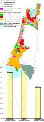 Fig-7: Palestine War up to 18th Jan 1949: Israel turned south again and occupied 10,000 sq. km. Its attack on Gaza Strip failed. Egypt signed the Armistice Agreement on 24 Feb 1949.
-
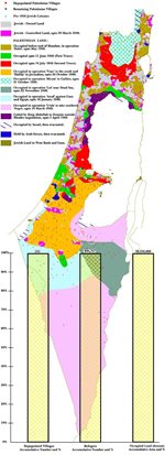 Fig-8: The last stage of Palestine War: In violation of Armistice Agreement, Israelis advanced to Um Rashrash (Eilat) and occupied all southern Palestine. Lebanon, then Syria signed Armistice Agreements. Thus 935,000Palestinians from 531 towns and villages became refugees. Their landis 92% of Israel today.
Israel turned south again, to the undefended Negev. It occupied areas east of Beer Sheba down to Dead Sea. The area occupied was 10,000 sq. km, or half the area of Israel today, or 7 times the Jewish pre 1948 land. Yet, Israel’s appetite was not satisfied. It turned west to attack Gaza Strip which became the place of refuge for about a quarter million refugees. But they were repulsed. Had they succeeded, there would have been a horrible massacre and Gaza Strip would not have existed. Egypt signed the Armistice Agreement on 24 February 1949.
Palestine War: From 19 January to 20 July 1949 [Fig-8]
Immediately after signing the Armistice Agreement with Egypt, Rabin proceeded south and occupied the remainder of Negev till Aqaba Gulf. He planted the Israeli flag at Um Rashrash (now Eilat). The Israeli-occupied area thus expanded to 19,600 sq. km, 13 times the Jewish land. Under the threat of Israeli attack on West Bank and Transjordan and with the Arab (Jordanian) Legion under British officers and with no ammunition, King Abdallah surrendered 436 sq. km of very fertile and populated land in Wadi Ara in central Palestine to Israel. Today, this is another Palestinian enclave in Israel, with Um el Fahm, its principal city. Soon thereafter, Lebanon, then Syria last, signed Armistice Agreements with Israel. These Agreements are “temporary” pending a final peace settlement. As their clauses state, they do not confer any rights on any party or deprive it from its rights. Israel turned the Armistice Line into “borders” with Egypt and Jordan in accordance with the peace agreements. In Palestine, the Armistice Line of 1949 separates Israel from the West Bank and Gaza. This Line has been deceptively dubbed the Green Line by Israel in order to strip it of its legal and factual meaning.
Thus ended the first chapter of al Nakba. Over 800,000 Palestinians were expelled from 531 towns and villages, in addition to 130,000 from 662 secondary small villages and hamlets, making a total of 935,000 refugees.
The Jews, who had dubious ownership of not more than 1,682 sq. km, have now occupied a total of 20,323 sq. km and called it Israel. This means that 92% of Israel is Palestinian.
By any standards this is the largest organized and still maintained ethnic cleansing operation in modern history. No understanding of the refugee problem is possible, let alone any attempt to solve it, without understanding the graphic and detailed sequence of dispossession and expulsion of refugees. This is the ugly reality of Al Nakba anatomy.